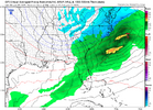
Holy crap, GFS is absolutely dumping on North Georgia.


Thats the ticket gets just a hair tick of juice , which is all it needs and no massive waaWe completely left the ULL off into Baja and let the northern stream energy take over.
Seriously how is this even possible for central GA and SC? I’ll never understand the back and forth in models.Holy crap, GFS is absolutely dumping on North Georgia.
View attachment 159688


That’s not accurateWith temps of 33-35 snow may fall but will not accumulate much.
Best option at this point to avoid temp profile issues, lighter amounts sure but for many it means all snowWe completely left the ULL off into Baja and let the northern stream energy take over.
Ive noticed that past 2 cycles. Its been like 30% plus. Im talking hits, not just frozen passing byThere were several ensemble panels that have been showing this as an option so not a huge surprise. But I'm all for it!
Yep unless it trends considerably faster or weaker it has to come out of the equation to a large degree. It can hand off some energy or do a partial phase but absorbing/ getting phased into by the trailer is immediately going to pump the SER and warm the pattern regardless of the north Atlantic

under discussed feature is that the orientation of the baja low points an atmospheric river at us. that's what allows this thing to be a qpf nuke even with so/so forcing. the funny thing is, and i think 1300m others would agree with me here, is that we are absolutely not at the ceiling of this event.


The weather model is trying to predict where an air parcel in Japan is going to end up a week from now. Multiply that by a million. Not. Easy.Seriously how is this even possible for central GA and SC? I’ll never understand the back and forth in models.
Its really the temps, showing Charlotte 32 while Columbia 33, I tick down 1-2 could make this a massive system, a shift in the opposite, ruins thisThe GFS surprised me I have to say. It was a good run. I just hope it continues to come a little further deeper south with the snow...but looking better.


its the CMC, it always does this then 1-2 days out it with trend north like CRAZY!!!canadian is a whiff just fyi
Goodcanadian is a whiff just fyi

.jpeg")