bud006
Member
A few random pics from this morning in my part of the world. Happy to see so many cash in, and enjoyed tracking the storm with y’all.
—30—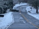
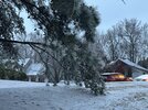 View attachment IMG_1769.jpeg
—30—


 View attachment IMG_1769.jpeg

 View attachment IMG_1769.jpeg
And that is exactly where I live in the 5.9 spot..Thanks for all the negativity.
Sent from my iPhone using Tapatalk
My area is still covered,,,Roads are a mess...Ice still in trees,,Gray dark overcast all day,,,30.9Well every bit of the frozen is gone. You wouldn't have thought a winter storm came through here yesterday.
For now….It’s nice to have my normal days back and not having to schedule my life around when the next set of models comes out
Still a winter wonderland here with 2 inches or so in most spots. Slush still on roads, and ice and snow are still on the trees. Temps have held steady at barely above freezing for a few hours. I expect some of the stuff in the sheltered spots might last until Monday or Tuesday. The snowmen will last a while anyway!
Till TomorrowIt’s nice to have my normal days back and not having to schedule my life around when the next set of models comes out
with sunshine and temps in the 40s tomorrow most of it will be gone
Definitely in the sunny areas, I face North with 0 solar radiation, my yard will take days to melt.with sunshine and temps in the 40s tomorrow most of it will be gone
OK, when’s the next one? Lol… I’m greedy like that.with sunshine and temps in the 40s tomorrow most of it will be gone
Beautiful picture...3.5” in North Buckhead near Chastain Park
View attachment 162852
heads up tonight
The ICON was the only model which for several of its last runs showed the light snowfall in SE Ga.
