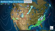
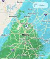
1. From my vantage point because the low level flow is coming directly from there on a steady NNE flow, I had said that the afternoon was a crucial period to see whether or not E SC temperatures would resume their slow drop this afternoon after a several hour long pause this morning. They ended up doing that:
Noon-4 PM change:
Myrtle Beach -1
Moncks Corner -2
Georgetown -2
CHS -3
Walterboro -2
Beaufort -1
SAV -3
Hunter -2
Ft Pulaski -2
2. My analysis of mesoscale models for 4 PM vs actuals for these locations showed the 18z NAM and 12Z RGEM to both be on average 3-4 F too warm and for the 20Z HRRR to be only about 1 F too warm.
Therefore, the NAM and RGEM are more than likely going to end up being several degrees too warm for at least the early part of tonight for much of the CHS-SAV corridor. But the HRRR likely will be closer, perhaps only 1-2 F too warm in at least a good portion of the area.
3. Based I assume on this and other info, CHS at 3:30 PM extended the winter wx advisory down to here for near 1/10" of ice accumulation. That would be the first wintry precip. here in 4 years. For now at 5 PM, Hunter/KSAV are safely above 32 at 38/37. However, upstream from here Walterboro has just dropped 2 the last hour to 32 and KCHS has been at 33 for the last 2 hourlies.
@Stormsfury and @Sctvman and others in the CHS-SAV corridor might find this info interesting.


