Webberweather53
Meteorologist
When is the earliest we can expect the atmosphere to respond in North America to a dead La Niña
I think it could start to impact things as early as later in February or March
When is the earliest we can expect the atmosphere to respond in North America to a dead La Niña
Just down the road in Seymour. Looks like a decent shower is heading my wayView attachment 177523
9:30 PM: Currently trying to time the incoming wave of sleet with Smoky Mountain Christmas fireworks. Wish me luck
Man, I've had to replace bushes that froze in North Alabama for the last two winters. I've never had to do that before. It's getting cold here.Another warmer than average winter , the norm these days
It began to sleet right as we got to the carJust down the road in Seymour. Looks like a decent shower is heading my way
lol cold last what maybe day half to two days … climate is warming upMan, I've had to replace bushes that froze in North Alabama for the last two winters. I've never had to do that before. It's getting cold here.
Not good be honest
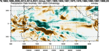

Contrary to popular belief, you don't need El Niño to get cold in the E US in Feb & we won't see an ENSO transition that quickly here this year.
Oth, even just a subtle eastward shift of the Indo-Pacific Warm Pool (IPWP) to push the ENSO state to something in between Modoki/Central Pacific Nino & classic La Niña by February (with warming focused west of the Int'l Dateline) is more than enough.
Unlike a majority of-ENSO winters, this year could have a few tricks up its sleeve to make the seasonal forecast more uncertain later in the winter

I remember reading somewhere that an east QBO also promotes more blocking which would be nice.The fact that we're in an easterly QBO atm also makes me think this is a real possibility
We tend to see significantly more MJO days in the Tropical West Pacific during East QBO winters (which is likely what we'd need this year to see a colder finish to winter (unlike the Nina stereotype).
https://agupubs.onlinelibrary.wiley.com/doi/10.1002/2017JD028171
View attachment 177566
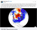
Takes a few weeks to effect us if we get cold over hereGlenn Burns mentioned these guys today:
Long range / seasonal forecast Archives
Long-range (seasonal) weather forecasts for Winter, Spring, Summer, and Autumn/Fall in the United States, Europe, and also the rest of the worldwww.severe-weather.eu
View attachment 177585
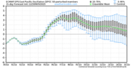
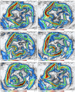


Do you still like the 15th dec through mid Jan for best opportunities for winter weather?Looking out into mid-December, the models of course aren't looking ideal with the forecasted +EPO, Alaska trough/low
View attachment 177587
Long range GFS and all, but it shows the proper jet extension we need to see (out towards Hawaii) to get more cold air involved with a big western ridge developing.
View attachment 177588
The Paul Roundy product also shows this type of AK ridge. This product is a combination of the 100-day averaged convective signal (OLR) (i.e. the base tropical forcing pattern signal) overlayed with the MJO progression and the "equatorial Rossby band signals"
View attachment 177594
View attachment 177595
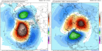
Also, there continues to be indications of SPV reflection / stretching in the modeling. Here is the 12z Euro run showing the Canadian Warming on Nov 30 evolving into a stretched SPV on Dec 15
View attachment 177592
So, some mixed signals going forward, but let's see if the pattern on the modeling can improve in time.
I see no reason to change that at this point. I didn't think the SPV weakening would be reflective in nature. That lessons the high latitude blocking potential, but if we get the SPV stretching, it could lead to more arctic outbreak potential - so, pick your 'poison' there. In the end, it's just a forecast. Plenty can go right / plenty can go wrongDo you still like the 15th dec through mid Jan for best opportunities for winter weather?
I know the SSW just started and that andrej that does a blog from overseas thinks it could be pretty interesting in a few weeks due to that SSW. Im hoping it can bring some cold and winter weatherI see no reason to change that at this point. I didn't think the SPV weakening would be reflective in nature. That lessons the high latitude blocking potential, but if we get the SPV stretching, it could lead to more arctic outbreak potential - so, pick your 'poison' there. In the end, it's just a forecast. Plenty can go right / plenty can go wrong
Was gonna say. Seems like model trends last 36-48 hours have been on the blander side. Wondered if it was a lack of model recognition with the MJO because phase 8 really does not favor a +EPOLooking out into mid-December, the models of course aren't looking ideal with the forecasted +EPO, Alaska trough/low
View attachment 177587
Long range GFS and all, but it shows the proper jet extension we need to see (out towards Hawaii) to get more cold air involved with a big western ridge developing.
View attachment 177588
The Paul Roundy product also shows this type of AK ridge. This product is a combination of the 100-day averaged convective signal (OLR) (i.e. the base tropical forcing pattern signal) overlayed with the MJO progression and the "equatorial Rossby band signals"
View attachment 177594
View attachment 177595
Also, there continues to be indications of SPV reflection / stretching in the modeling. Here is the 12z Euro run showing the Canadian Warming on Nov 30 evolving into a stretched SPV on Dec 15
View attachment 177592
So, some mixed signals going forward, but let's see if the pattern on the modeling can improve in time.
I’m gonna need a new pair of flip flops
Same old Nina song and dance each year. Copy and paste....
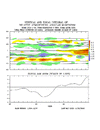
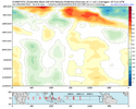
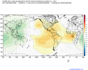
If we continue to follow the Nina script this winter as closely as we have been this fall, odds are the MJO probably will be slowly lumbering through the Indian Ocean & into the Maritime Continent (phase 3-4-5 ish) for the bulk of January. Maybe we return to the West Pac again late in January or February to deliver the knock out blow to La Niña that shows up in the springtime.
Phase 3-4 MJO composites are very close to what the last 30 years of La Niña Januarys look like
View attachment 176193
View attachment 176194
View attachment 176195
Eric, I'm not a meteorologist like yourself, but it sounds like january may be real warm if indeed the mjo is in phases 3-5 then. Hoping that isn't the case. I guess we hope for SSW action where we get cold air here from it?The lead-up to the next West-Central Pacific MJO orbit will probably be the most favorable subseasonal window for western troughing this entire winter.
Imho, the million dollar question ultimately is going to be: how large is this favorable -PNA window? Does this window last for most of the rest of the winter after the New Year, or do we triumphantly flip back to a big & cold +TNH pattern in February? Honestly, I'm still not sure.
Normally, in a majority of La Niña winters it often lasts for the bulk of both January and especially February and I typically feel pretty confident in that outcome. However, this year is not like a majority of La Niña winters in that an El Niño is likely lurking on the horizon. Even a subtle shift to the mean ENSO state during this transition period in late winter can (& often does) dramatically change the downstream pattern and the sensible impacts from what you'd normally expect. In our case, a subtle eastward shift in the Indo-Pacific Warm Pool & the underlying ENSO base state towards a hybrid modoki El Niño - classic La Niña pattern that couples with the MJO in Feb would give us an opportunity to see something like Feb 2014 instead of the canonical Nina look this time around. However, I still need to see how much the Warm Pool responds to this latest MJO event (which is still ongoing).
Also, to further muddy the canonical Nina potential in late winter this year, the tropical troposphere is already in a very heavy El Niño-like state, w/ a giant build-up of +AAM anomalies. When a portion of this reservoir of westerly momentum gets fluxed poleward into the subtropics & mid-latitudes during the next Eastern Hemisphere MJO orbit, extratropical teleconnections could deviate somewhat from the typical/expected MJO + La Niña configuration because the stronger westerly background flow would be capable of advecting the planetary waves eastward a bit more.
It's honestly pretty incredible to see 3 sigma global mean AAM anomalies like this during a Nina winter, we're going to need a bigger chart here soon...
View attachment 177666
The latest European Weeklies are fwiw loading up the next significant MJO event over the Warm Pool in January, which is generally in line with my general thoughts from a month ago (at least for now).
View attachment 177663
View attachment 177665

This December nina coastal going to hit like Crack
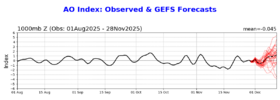
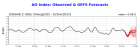
Yeah hopefully the warm solution s verify. Know not a popular opinion on here. But cold with no snow sucksToday’s Euro Weeklies for week 3+ are still lacking cold domination to return to most of the E US south of the N tier with a solid -PNA dominating through mid Jan along with no -NAO or -AO. If this verifies, it would likely be pretty mild in much of the E US and especially SE US and nothing like we’ve been experiencing the last 2 weeks. However, models the last 3 weeks have been too warm in the E US with too much SER and missing much of the -NAO and -AO. Also, Midwest snowcover is well above avg, there’s the potential lag effects from the 11/28/25 SSWE, and the MJO remains favorable for E US cold.
Are the weeklies/models finally getting their act together or are they going to continue with the same errors? Opinions?
You have to get cold without snow first.... then you might have a chance at snow. Without the cold, you will never have a chance. You people want 1 day of cold and snow followed by weeks of torch? Makes no sense.Yeah hopefully the warm solution s verify. Know not a popular opinion on here. But cold with no snow sucks
Literally. It's swamp ass hot 6-7 months out of the year and these people want warm winters lololYou have to get cold without snow first.... then you might have a chance at snow. Without the cold, you will never have a chance. You people want 1 day of cold and snow followed by weeks of torch? Makes no sense.
I feel you on this one. I’m the biggest snow lover ever but it does. We’ve gotten 30s and rain multiple times this year. I’m rooting for a wintry pattern hard, but man it ain’t this oneYeah hopefully the warm solution s verify. Know not a popular opinion on here. But cold with no snow sucks
