
• Hello, please take a minute to check out our awesome content, contributed by the wonderful members of our community. We hope you'll add your own thoughts and opinions by making a free account!

Wintry Winter 26-27

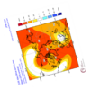
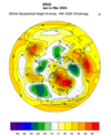
This is a hardcore -AO/-NAO on the Nov release of the UK Met Office GloSea6 (Global Seasonal Forecast System). I would consider the Euro and UK GloSea as the 2 best at predicting the NAO. Of course, who knows if it is correct this year.

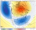
Loop of the Oct & Nov runs at 500mb for Jan-Mar - the blues got blue-er! Suppressed storm track with -AO/-NAO.

Nov 10 Glosea Loop.gif

Nov 10 UK T.png

Nov 10 UK P.png

Nov 10 UK SPV.png
 
This is a hardcore -AO/-NAO on the Nov release of the UK Met Office GloSea6 (Global Seasonal Forecast System). I would consider the Euro and UK GloSea as the 2 best at predicting the NAO. Of course, who knows if it is correct this year.

Loop of the Oct & Nov runs at 500mb for Jan-Mar - the blues got blue-er! Suppressed storm track with -AO/-NAO.

View attachment 199526

View attachment 199527

View attachment 199528

View attachment 199529
Crying Inside GIF
 
Generally still following the typical Nino script, though I think this year isn't going to be quite as mild as either of these years in the SE US and mid-Atlantic perhaps.

Wonder why so many Ninos do this in late Nov. Maybe it has something to do with the South Pacific Convergence Zone overspreading the Subtropical South Pacific at this time of the year (as it often does). Gets into a bit of a chicken-egg argument w/ the MJO forcing this to occur or these climatological changes in the SPCZ attracting the MJO at this specific time of year.

 
Generally still following the typical Nino script, though I think this year isn't going to be quite as mild as either of these years in the SE US and mid-Atlantic perhaps.

Wonder why so many Ninos do this in late Nov. Maybe it has something to do with the South Pacific Convergence Zone overspreading the Subtropical South Pacific at this time of the year (as it often does). Gets into a bit of a chicken-egg argument w/ the MJO forcing this to occur or these climatological changes in the SPCZ attracting the MJO at this specific time of year.


I agree that any -EPO late this month would likely not be a sign of things to come for DJF per history of strong+ Ninos:

1957-8: +EPO

1965-6: slight +EPO

1972-3: slight -EPO with wild swings

1982-3: +EPO

1986-7: neutral

1991-2: slight +EPO

1997-8: +EPO

2009-10: -EPO

2015-6: +EPO

2023-4: slight +EPO


Tally:

4 moderate+ +EPO

3 slight +EPO

1 neutral

1 slight -EPO

1 moderate+ -EPO

—————


-So, +EPO is clearly favored in the means although not prohibitively. Thus predicting mean +EPO for DJF for a strong+ Nino makes sense based on the percentages.

-But a mean +EPO/-EPO during El Niño doesn’t necessarily mean a mild/cold winter, especially in the SE.

These two +EPO winters had net BN temps in the E US overall:

1957-8

1965-6

——————

Also, although a slight -EPO, 1972-3 averaged mild in the NE and Mid-Atlantic.

—————

Although a mean +EPO is normally favored in a Nino this strong, having 1-2 periods of strong -EPO would be expected:

-1957-8 had one strong -EPO week in Feb
-1965-6 had two weeklong -EPO periods
-1982-3 had one 6 day long -EPO period
-1991-2 had one 9 day -EPO period
-1997-8 had one 6 day -EPO period.
-2015-6 had one 14 day -EPO period
-2023-4 had one 7 day -EPO period

(I count sub 50+/ -50- as +EPO/-EPO)

 
Last edited:
There were solid -EPO periods in Nov, especially late, prior to all 7 of the strong+ Nino DJFs since 1957-8 that averaged +EPO:

2023 11 22 -78.82
2023 11 23 -148.98
2023 11 24 -211.45
2023 11 25 -236.28
2023 11 26 -193.93
2023 11 27 -113.90
2023 11 28 -66.01

2023 11 29 -15.82
2023 11 30 65.45
2023 12 01 141.37
2023 12 02 176.29
2023 12 03 219.42


2015 11 21 -60.21
2015 11 22 -77.56
2015 11 23 -115.41
2015 11 24 -163.95
2015 11 25 -184.63
2015 11 26 -180.21
2015 11 27 -125.28
2015 11 28 -111.09
2015 11 29 -99.72

2015 11 30 -11.12
2015 12 01 61.54
2015 12 02 79.63
2015 12 03 122.36
2015 12 04 168.33
2015 12 05 143.40
2015 12 06 161.07
2015 12 07 224.09
2015 12 08 239.83
2015 12 09 234.97


1997 11 07 -81.76
1997 11 08 -130.77
1997 11 09 -90.43
1997 11 10 -53.79
1997 11 11 -34.48
1997 11 12 -74.06
1997 11 13 -150.91
1997 11 14 -219.72
1997 11 15 -203.60
1997 11 16 -140.59
1997 11 17 -91.51
1997 11 18 -48.91
1997 11 19 -73.61
1997 11 20 -112.12
1997 11 21 -64.65

1997 11 22 -18.69
1997 11 23 66.86
1997 11 24 93.01
1997 11 25 65.52
1997 11 26 116.60
1997 11 27 205.65
1997 11 28 120.58
1997 11 29 92.18
1997 11 30 106.80


1991 11 28 -105.08
1991 11 29 -178.40
1991 11 30 -203.96
1991 12 01 -133.69
1991 12 02 -90.16

1991 12 03 3.92
1991 12 04 83.24
1991 12 05 127.86
1991 12 06 165.92
1991 12 07 135.94


1982 11 20 -54.98
1982 11 21 -129.65
1982 11 22 -162.63
1982 11 23 -160.29
1982 11 24 -151.70
1982 11 25 -85.13

1982 11 26 1.95
1982 11 27 85.63
1982 11 28 163.35
1982 11 29 221.58
1982 11 30 224.00
1982 12 01 158.87
1982 12 02 132.74
1982 12 03 162.95


1965 11 05 -137.28
1965 11 06 -216.20
1965 11 07 -271.63
1965 11 08 -275.26
1965 11 09 -234.16
1965 11 10 -196.56
1965 11 11 -201.16
1965 11 12 -245.79
1965 11 13 -266.58
1965 11 14 -240.39
1965 11 15 -146.24
1965 11 16 -146.09
1965 11 17 -168.70
1965 11 18 -187.29
1965 11 19 -142.17
1965 11 20 -23.14
1965 11 21 55.32
1965 11 22 -28.39
1965 11 23 -145.06
1965 11 24 -133.01

1965 11 25 -25.64
1965 11 26 89.01
1965 11 27 109.27
1965 11 28 55.32
1965 11 29 73.60
1965 11 30 103.10
1965 12 01 83.35
1965 12 02 52.42
1965 12 03 112.76
1965 12 04 202.08


1957 11 20 -103.78
1957 11 21 -124.54
1957 11 22 -50.16
1957 11 23 -72.30

1957 11 24 -23.15
1957 11 25 48.08
1957 11 26 68.65
1957 11 27 98.83
1957 11 28 69.36
1957 11 29 29.64
1957 11 30 49.03
1957 12 01 44.90
1957 12 02 91.92
1957 12 03 111.08
1957 12 04 136.50
1957 12 05 204.61
1957 12 06 233.56


@Webberweather53
 
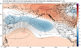
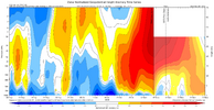
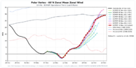
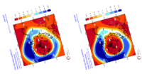
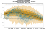
The high-latitude North Pacific blocking ridge (-EPO) forced in large part by the fast MJO event in the West Pacific, should allow the stratospheric warming event to "anchor" itself into the troposphere for a bit.

Hence, the "dripping paint" look on the stratosphere vertical cross sections.

This same wave pattern reduces upward propagating planetary wave activity and will allow the polar vortex to restrengthen some as we head towards early December. On the other hand, I do anticipate more potential disruptions to the polar vortex later in December &/or January.

aifs-ens_z500aMean_npac_11.png


zonal_norm_era_gph_last60_20261111_06Z.png
 
Jealous that I won’t be able to experience this upcoming pattern with y’all! I really like the VA/NC/ TN folks chances in December for a nice system or two. I’m not a climatologist by any means but things look favorable in my opinion.
 
Jealous that I won’t be able to experience this upcoming pattern with y’all! I really like the VA/NC/ TN folks chances in December for a nice system or two. I’m not a climatologist by any means but things look favorable in my opinion.
We’ll make sure to spam the chat with photos man 😂

Forreal tho happy for you and the opportunity you have out west. Hoping El Niño throws you some bones as well.
 
Jealous that I won’t be able to experience this upcoming pattern with y’all! I really like the VA/NC/ TN folks chances in December for a nice system or two. I’m not a climatologist by any means but things look favorable in my opinion.
Correct me if I'm wrong but I thought you were moving to the Flagstaff area for work? Beautiful country and more snow than we see here. I passed through there back in 04 going to Twentynine Palms CA and if not for uprooting my family I would love to me there.
 
I personally would rather not see a -epo in end of November if it follows same script of it turning positive later. Unless your in the favored higher elevations or mountains, be tough to see much winter weather, albeit it had happened before, but not often. I on the bandwagon of the niño "surprising" alot of people and it being colder than one believes
 
I personally would rather not see a -epo in end of November if it follows same script of it turning positive later. Unless your in the favored higher elevations or mountains, be tough to see much winter weather, albeit it had happened before, but not often. I on the bandwagon of the niño "surprising" alot of people and it being colder than one believes
Iv said it before and I’ll say it again. Give me cold WHENEVER I can get it. We never know what’s in store. Give me the cold and then I’ll worry about what comes next after. Plus, it’s nice for the holidays to feel like the holidays.
 
26b7dad614626c8ad33e0587bf1e6e46.png

According to David Gold’s data, the +EAMT that just occurred yesterday was the strongest +EAMT since 1968. To date, there have been 7 of those just this year @Webberweather53


Sent from my iPhone using Tapatalk
 
Back
Top