• Hello, please take a minute to check out our awesome content, contributed by the wonderful members of our community. We hope you'll add your own thoughts and opinions by making a free account!

Wintry Winter 26-27

The "warmest summer" will be coming to a close. But gradually, with no drama.

We still are looking at perhaps another 7 to 8 days of warm/hot temperature averages around the lower 48 states, with an obvious concentration in the southern third of the nation and in the Great Plains. This has been the general idea for the national pattern in JJA, which will probably translate to the most heated JJAS quarter before autumn awakes and starts to return summer lovers to reality. Namely, that El Nino will assert itself in altering the 500MB longwave pattern. As in eliminating the persistent hybrid of the Sonoran Heat Ridge and the Bermuda High.

There are two possible features that will conspire to alter the upper air configuration. One will be tropical, either from the Mexican pacific shoreline or (more likely) from the Caribbean Sea/Gulf of Mexico. The strength of this feature is likely to be undecided for the next few days, but I am confident it will be involving western Cuba and Florida in the later medium range. The circulation and convective field should open up a weakness aloft, enabling the shortwave in the polar westerlies to descend/dig into the Mississippi Valley as we start the longer term period. That will crack the ridge, while another low emerges in the southern branch from California on southward. The tendency for blocking may enable a deeper storm in the Southwest, which is showing up as a cool deviation near the "Four Corners". The warmest values likely would shift into the Pacific Northwest, northern Intermountain Region and Great Plains.

Now about the El Nino. You can easily see that the episode has plateaued, and the CFS series has backed off from the absurdly high warmth projected in Sector 3.4 (from +4.0 deg C to closer to +3.0 deg C). More and more this hydrothermal array looks very close to what happened in 1997-98, but with the caveat that the signature will undergo rapid collapse starting in December. I would not get excited about some La Nina projections in Spring 2027 (way too early....), but a negative/neutral placement is certainly possible. October and November may have many neutral/cool outcomes in the USA, but the reality of all that warmth to start likely means a very mild December and much of January. But I need to repeat the idea that the numerical models are seeing something that would cause an end to the "warm rush" in a hurry. I am toying with the scenario of a deep Kona Low and frequent -EPO/-AO/-NAO ridging, which would mean a very mild northern 2/3 of the country with a neutral, stormy south running into a speed bump around and after Dr. King's Birthday in the New Year.

I will try to conceal my excitement for the weather in the coming months. And at the same time remind people that it is a "strong" and not necessarily a "Super" El Nino. You know how much I hate hype, right?


Prepared by Meteorologist LARRY COSGROVE on
Saturday, September 12, 2026 at 11:20 P.M. CT

So many words to say nothing
 
The "warmest summer" will be coming to a close. But gradually, with no drama.

We still are looking at perhaps another 7 to 8 days of warm/hot temperature averages around the lower 48 states, with an obvious concentration in the southern third of the nation and in the Great Plains. This has been the general idea for the national pattern in JJA, which will probably translate to the most heated JJAS quarter before autumn awakes and starts to return summer lovers to reality. Namely, that El Nino will assert itself in altering the 500MB longwave pattern. As in eliminating the persistent hybrid of the Sonoran Heat Ridge and the Bermuda High.

There are two possible features that will conspire to alter the upper air configuration. One will be tropical, either from the Mexican pacific shoreline or (more likely) from the Caribbean Sea/Gulf of Mexico. The strength of this feature is likely to be undecided for the next few days, but I am confident it will be involving western Cuba and Florida in the later medium range. The circulation and convective field should open up a weakness aloft, enabling the shortwave in the polar westerlies to descend/dig into the Mississippi Valley as we start the longer term period. That will crack the ridge, while another low emerges in the southern branch from California on southward. The tendency for blocking may enable a deeper storm in the Southwest, which is showing up as a cool deviation near the "Four Corners". The warmest values likely would shift into the Pacific Northwest, northern Intermountain Region and Great Plains.

Now about the El Nino. You can easily see that the episode has plateaued, and the CFS series has backed off from the absurdly high warmth projected in Sector 3.4 (from +4.0 deg C to closer to +3.0 deg C). More and more this hydrothermal array looks very close to what happened in 1997-98, but with the caveat that the signature will undergo rapid collapse starting in December. I would not get excited about some La Nina projections in Spring 2027 (way too early....), but a negative/neutral placement is certainly possible. October and November may have many neutral/cool outcomes in the USA, but the reality of all that warmth to start likely means a very mild December and much of January. But I need to repeat the idea that the numerical models are seeing something that would cause an end to the "warm rush" in a hurry. I am toying with the scenario of a deep Kona Low and frequent -EPO/-AO/-NAO ridging, which would mean a very mild northern 2/3 of the country with a neutral, stormy south running into a speed bump around and after Dr. King's Birthday in the New Year.

I will try to conceal my excitement for the weather in the coming months. And at the same time remind people that it is a "strong" and not necessarily a "Super" El Nino. You know how much I hate hype, right?


Prepared by Meteorologist LARRY COSGROVE on
Saturday, September 12, 2026 at 11:20 P.M. CT
Well put , couldn’t say this better myself
 
Is this the Larry Cosgrove that predicted a Christmas to remember? I'm still not over that

And no I didn't mean all time winter record highs memorable
I hate to crap on the guy, deep within these text walls there's usually a nugget or 2 of decent info. There's just so many characters to basically say nino climo
 
-Sep Jamstec winter forecasts going back to 2017-8 are available at their site to compare to

-Sep ‘26 is vs all Sep forecasts back to ‘17 by a good margin the coldest DJF in the CONUS overall, by a very wide margin the coldest DJF in the E 1/2 overall, and is easily the coldest for the SE, midsouth, S Plains, Ohio Valley, and Mid-Atlantic. I couldn’t even find a colder one than this for the corridor from Chic to NYC.

-Sep ‘26 is the wettest overall for the E US vs the other Sep DJF forecasts

-June-Sep ‘26 are all very similar in the CONUS for DJF ‘26-7 and are the most consistent of any DJF forecasts back to 2017-8!

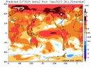
Here’s the ‘23 Sep forecast for DJF for comparison (the 2nd coldest since ‘17): coldest is -0.5 to -1C:

IMG_1635.png


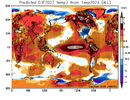
Compare that to ‘26: like night and day with coldest -2 to -3C! This would easily be the coldest winter for the SE, Mid-South, and S Plains since 2014-5:

IMG_2511.png


How did Sep JAMSTEC verify in the E US overall?

’17: too warm NE/close SE

’18: close NE/too cold SE

’19: too cold

’20: close NE/too warm SE

’21: N/A

’22: too cold

’23: too cold

’24: too warm

’25: too warm


So, for these 8 winters, Jamstec:

-in NE was too warm 3 times, too cold 3 times, and close twice…so neutral bias averaged out

-in SE was too warm 3 times, too cold 4 times, and close once…so, very slight cold bias but pretty neutral overall averaged out

-Keep in mind that this cold E US forecast is with Jamstec progging an E based super Nino.
 
-Sep Jamstec winter forecasts going back to 2017-8 are available at their site to compare to

-Sep ‘26 is vs all Sep forecasts back to ‘17 by a good margin the coldest DJF in the CONUS overall, by a very wide margin the coldest DJF in the E 1/2 overall, and is easily the coldest for the SE, midsouth, S Plains, Ohio Valley, and Mid-Atlantic. I couldn’t even find a colder one than this for the corridor from Chic to NYC.

-Sep ‘26 is the wettest overall for the E US vs the other Sep DJF forecasts

-June-Sep ‘26 are all very similar in the CONUS for DJF ‘26-7 and are the most consistent of any DJF forecasts back to 2017-8!

Here’s the ‘23 Sep forecast for DJF for comparison (the 2nd coldest since ‘17): coldest is -0.5 to -1C:

View attachment 198078


Compare that to ‘26: like night and day with coldest -2 to -3C! This would easily be the coldest winter for the SE, Mid-South, and S Plains since 2014-5:

View attachment 198079


How did Sep JAMSTEC verify in the E US overall?

’17: too warm NE/close SE

’18: close NE/too cold SE

’19: too cold

’20: close NE/too warm SE

’21: N/A

’22: too cold

’23: too cold

’24: too warm

’25: too warm


So, for these 8 winters, Jamstec:

-in NE was too warm 3 times, too cold 3 times, and close twice…so neutral bias averaged out

-in SE was too warm 3 times, too cold 4 times, and close once…so, very slight cold bias but pretty neutral overall averaged out

-Keep in mind that this cold E US forecast is with Jamstec progging an E based super Nino.
Thank you for posting this. We are either in for an amazing winter board wide, or an epic bust of pretty much all the long range seasonal models. Are any of them showing warm at all?
 
I wish I was feeling better out here but the analogs are pretty scary still. About the worst ones you can draw up I dunno

Maybe it'll be better once it stops being 100 degrees 🙄 but even that....the last time we were this hot this late it was an ugly winter

And I'm always gonna have concerns about their being too much El Nino and Pacific air until proven otherwise
 
I wish I was feeling better out here but the analogs are pretty scary still. About the worst ones you can draw up I dunno

Maybe it'll be better once it stops being 100 degrees 🙄 but even that....the last time we were this hot this late it was an ugly winter

And I'm always gonna have concerns about their being too much El Nino and Pacific air until proven otherwise
After this hot summer, winter in the 70s and 80s would feel great.
 
I wish I was feeling better out here but the analogs are pretty scary still. About the worst ones you can draw up I dunno

Maybe it'll be better once it stops being 100 degrees 🙄 but even that....the last time we were this hot this late it was an ugly winter
And I'm always gonna have concerns about their being too much El Nino and Pacific air until proven otherwise
Plus 1
 
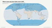
Not sure this is 100% accurate and it’s a little too course to see some mountain peaks such as Mauna Kea / Mauna Loa / Haleakala in Hawaii, but still interesting!

View attachment 198084

I can’t tell if this is showing it, but don’t forget that Homestead and Miami as well as Freeport on Grand Bahama Island had snow flurries on 1/19 during the great winter of 1976-7!
 
Not sure this is 100% accurate and it’s a little too course to see some mountain peaks such as Mauna Kea / Mauna Loa / Haleakala in Hawaii, but still interesting!

View attachment 198084
For some reason, I thought Australia would have more coverage than that. But maybe its moderated by surrounding ocean and proximity to equator. I dunno. Never paid much attention to southern hemisphere.
 
Thanks for posting.

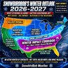
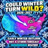
Is it my imagination or is the forecaster Snowbird like everywhere? And who is this bird, anyway? Any relation to our bird? I get the impression Snowbird is a hypester wanting millions of clicks.
Other opinions?
I think he's an ex-con just in it for clicks/HYPE. Charlatan. Short term attention over quality. He gets posted here a lot I think for the laughs. Can't say what his reach outside of this forum though. (I don't do the Twitter/Youtube weather channels much outside of winter)

Also, I doubt he's any relation to "our bird", who displays some interesting quirks himself but probably not an ex-con. (not yet)
 
I think he's an ex-con just in it for clicks/HYPE. Charlatan. Short term attention over quality. He gets posted here a lot I think for the laughs. Can't say what his reach outside of this forum though. (I don't do the Twitter/Youtube weather channels much outside of winter)

Also, I doubt he's any relation to "our bird", who displays some interesting quirks himself but probably not an ex-con. (not yet)

You are correct he is not a meteorologist he is an ex con who did 5 years for covid fraud. His name is James Read .


Sent from my iPhone using Tapatalk
 
For some reason, I thought Australia would have more coverage than that. But maybe its moderated by surrounding ocean and proximity to equator. I dunno. Never paid much attention to southern hemisphere.
Also, it almost appears the Northern Hemisphere snow line is further south than the Southern Hemisphere is north. And outside of Antarctica of course, vast majority of landmass in Southern Hemisphere hasn't seen snow. Interesting
 
Also, it almost appears the Northern Hemisphere snow line is further south than the Southern Hemisphere is north. And outside of Antarctica of course, vast majority of landmass in Southern Hemisphere hasn't seen snow. Interesting
That’s a good point. Yea it doesn’t get up north hardly at all except for the high elev Andes.

I’m thinking the southern having less land mass overall is a big factor—less overall temp extremes due to more ocean. Gets moderated. Tougher for those bitter cold blasts to get through. (I almost typed Arctic blasts but caught myself :p)
 
That’s a good point. Yea it doesn’t get up north hardly at all except for the high elev Andes.

I’m thinking the southern having less land mass overall is a big factor—less overall temp extremes due to more ocean. Gets moderated. Tougher for those bitter cold blasts to get through. (I almost typed Arctic blasts but caught myself :p)
Yeah that makes sense for sure and arctic blast? What's that
 
Also, it almost appears the Northern Hemisphere snow line is further south than the Southern Hemisphere is north. And outside of Antarctica of course, vast majority of landmass in Southern Hemisphere hasn't seen snow. Interesting
From what I understand, the climate tends to be milder / less extreme (and thus less likely to produce temperatures cold enough for snow) in the Southern Hemisphere because there is far less landmass compared to the Northern Hemisphere. The Northern Hemisphere contains around 7/10ths of the world’s landmass. And then, on top of that, there is far less landmass far enough south for snow (Antarctica excepted). For example, the southern tip of the Australian “mainland” is at about the same latitude as Washington, D.C. and the southern tip of Africa is at about the same latitude as Greenville, SC. South America is the exception to this as the Cape Horn is at 56S.
 
From what I understand, the climate tends to be milder / less extreme (and thus less likely to produce temperatures cold enough for snow) in the Southern Hemisphere because there is far less landmass compared to the Northern Hemisphere. The Northern Hemisphere contains around 7/10ths of the world’s landmass. And then, on top of that, there is far less landmass far enough south for snow (Antarctica excepted). For example, the southern tip of the Australian “mainland” is at about the same latitude as Washington, D.C. and the southern tip of Africa is at about the same latitude as Greenville, SC. South America is the exception to this as the Cape Horn is at 56S.

Southern ocean modifies the Antarctic air a good bit but it still gets pretty cold in eastern Australia. Spent time there years ago and they routinely get decent snows not just in the mountains but their version of the Cumberland Plateau west of the mountains. Neat city called Armidale sitting at about 30S latitude gets plenty cold and snowy. Same latitude as Jacksonville FL and about the same elevation as Asheville. Main difference being the continental air is very dry and the snow evaporates quickly in the southern hemisphere sun.
 
I’ll just say that if we get any winter weather it will be backloaded, Jan-Feb. it’s not a fail if it doesn’t snow by Thanksgiving here in the NC. I can recall two Christmas snows in my life. The most snowfalls I can recall are in late Jan to Feb. I spent most of my life in eastern NC. So I guess I’m saying that no one has a clue out in September and we’ll have to wait and see!
 
Southern ocean modifies the Antarctic air a good bit but it still gets pretty cold in eastern Australia. Spent time there years ago and they routinely get decent snows not just in the mountains but their version of the Cumberland Plateau west of the mountains. Neat city called Armidale sitting at about 30S latitude gets plenty cold and snowy. Same latitude as Jacksonville FL and about the same elevation as Asheville. Main difference being the continental air is very dry and the snow evaporates quickly in the southern hemisphere sun.
Yea, the Xmas song dreaming of a white Xmas will live up to its name . It will be a dream. Our best chance will be later January into early February . Then spring we start to change gears go towards a la
Nina enso crazy
 
Yea, the Xmas song dreaming of a white Xmas will live up to its name . It will be a dream. Our best chance will be later January into early February . Then spring we start to change gears go towards a la
Nina enso crazy
I agree that we should definitely expect a mild December. However looking back at some of our stronger El Nino’s I was kinda surprised to see that a number of them did have at least a solid cold spell in the mid to late December time frame.
 
Back
Top