• Hello, please take a minute to check out our awesome content, contributed by the wonderful members of our community. We hope you'll add your own thoughts and opinions by making a free account!

Tropical Tropical Storm Dolly

0Z UKMET: doesn’t quite get it to Dolly strength but still has it as a TD although this run then weakens it while moving rapidly WNW in the MDR followed by a reformation 2 days later moving W much more slowly toward the SE Bahamas:

NEW TROPICAL CYCLONE FORECAST TO DEVELOP AFTER 48 HOURS
FORECAST POSITION AT T+ 48 : 12.4N 33.9W

LEAD CENTRAL MAXIMUM WIND
VERIFYING TIME TIME POSITION PRESSURE (MB) SPEED (KNOTS)
-------------- ---- -------- ------------- -------------
0000UTC 27.08.2026 48 12.4N 33.9W 1010 28
1200UTC 27.08.2026 60 13.0N 37.8W 1009 30
0000UTC 28.08.2026 72 13.2N 42.0W 1009 31
1200UTC 28.08.2026 84 14.1N 46.7W 1010 32
0000UTC 29.08.2026 96 CEASED TRACKING


NEW TROPICAL CYCLONE FORECAST TO DEVELOP AFTER 150 HOURS
FORECAST POSITION AT T+150 : 20.3N 67.0W

LEAD CENTRAL MAXIMUM WIND
VERIFYING TIME TIME POSITION PRESSURE (MB) SPEED (KNOTS)
-------------- ---- -------- ------------- -------------
1200UTC 31.08.2026 156 21.0N 68.4W 1010 34
0000UTC 01.09.2026 168 20.9N 70.6W 1009 32
 
0Z UKMET: doesn’t quite get it to Dolly strength but still has it as a TD although this run then weakens it while moving rapidly WNW in the MDR followed by a reformation 2 days later moving W much more slowly toward the SE Bahamas:

NEW TROPICAL CYCLONE FORECAST TO DEVELOP AFTER 48 HOURS
FORECAST POSITION AT T+ 48 : 12.4N 33.9W

LEAD CENTRAL MAXIMUM WIND
VERIFYING TIME TIME POSITION PRESSURE (MB) SPEED (KNOTS)
-------------- ---- -------- ------------- -------------
0000UTC 27.08.2026 48 12.4N 33.9W 1010 28
1200UTC 27.08.2026 60 13.0N 37.8W 1009 30
0000UTC 28.08.2026 72 13.2N 42.0W 1009 31
1200UTC 28.08.2026 84 14.1N 46.7W 1010 32
0000UTC 29.08.2026 96 CEASED TRACKING


NEW TROPICAL CYCLONE FORECAST TO DEVELOP AFTER 150 HOURS
FORECAST POSITION AT T+150 : 20.3N 67.0W

LEAD CENTRAL MAXIMUM WIND
VERIFYING TIME TIME POSITION PRESSURE (MB) SPEED (KNOTS)
-------------- ---- -------- ------------- -------------
1200UTC 31.08.2026 156 21.0N 68.4W 1010 34
0000UTC 01.09.2026 168 20.9N 70.6W 1009 32
If it’s going to be named Dolly it’s gonna have really really BIG…..
Winds
 
12Z UKMET: similar to 0Z run with TCG by tomorrow along with rapid WNW movement in MDR along with it barely reaching TS status before weakening back to a TD though this time it remains a TC and strengthens back to a TS late moving much more slowly WNW near SE Bahamas:

NEW TROPICAL CYCLONE FORECAST TO DEVELOP AFTER 30 HOURS
FORECAST POSITION AT T+ 30 : 13.0N 32.0W

LEAD CENTRAL MAXIMUM WIND
VERIFYING TIME TIME POSITION PRESSURE (MB) SPEED (KNOTS)
-------------- ---- -------- ------------- -------------
0000UTC 27.08.2026 36 13.0N 34.0W 1008 29
1200UTC 27.08.2026 48 13.2N 38.0W 1007 33
0000UTC 28.08.2026 60 13.8N 41.9W 1008 33
1200UTC 28.08.2026 72 14.6N 46.5W 1009 36
0000UTC 29.08.2026 84 15.6N 50.9W 1009 33
1200UTC 29.08.2026 96 16.9N 55.1W 1010 35
0000UTC 30.08.2026 108 17.8N 58.9W 1010 33
1200UTC 30.08.2026 120 19.0N 62.6W 1009 35
0000UTC 31.08.2026 132 19.6N 65.4W 1008 30
1200UTC 31.08.2026 144 20.5N 68.0W 1008 31
0000UTC 01.09.2026 156 21.3N 69.7W 1007 35
1200UTC 01.09.2026 168 22.2N 71.7W 1006 38
 
0Z UKMET delays transition to a TD for 4 days vs the 12Z run but still has it taking a similar path and gets to a TS quickly as it moves WNW a little NE of the Bahamas:

NEW TROPICAL CYCLONE FORECAST TO DEVELOP AFTER 126 HOURS
FORECAST POSITION AT T+126 : 20.3N 67.4W

LEAD CENTRAL MAXIMUM WIND
VERIFYING TIME TIME POSITION PRESSURE (MB) SPEED (KNOTS)
-------------- ---- -------- ------------- -------------
1200UTC 31.08.2026 132 21.0N 68.5W 1011 32
0000UTC 01.09.2026 144 22.4N 70.3W 1009 38
1200UTC 01.09.2026 156 23.0N 71.7W 1006 43
0000UTC 02.09.2026 168 24.1N 73.4W 1002 39
 
12Z UKMET develops it into a TD and fast! It moved TCG back up 4.5 days back to about when yesterday’s 12Z run had TCG, this evening! Like many runs before the 0Z, it has rapid WNW movement in the MDR while keeping it (mainly) a TD and then strengthens it to TS Dolly about when it leaves the MDR and slows down and later passes just NE of the Bahamas:

NEW TROPICAL CYCLONE FORECAST TO DEVELOP AFTER 12 HOURS
FORECAST POSITION AT T+ 12 : 13.8N 33.6W

LEAD CENTRAL MAXIMUM WIND
VERIFYING TIME TIME POSITION PRESSURE (MB) SPEED (KNOTS)
-------------- ---- -------- ------------- -------------
0000UTC 27.08.2026 12 13.8N 33.6W 1010 27
1200UTC 27.08.2026 24 13.6N 37.9W 1008 31
0000UTC 28.08.2026 36 13.8N 41.6W 1010 30
1200UTC 28.08.2026 48 14.4N 46.3W 1010 32
0000UTC 29.08.2026 60 15.0N 50.5W 1011 29
1200UTC 29.08.2026 72 16.4N 54.4W 1011 33
0000UTC 30.08.2026 84 17.5N 58.3W 1011 32
1200UTC 30.08.2026 96 18.6N 61.7W 1011 33
0000UTC 31.08.2026 108 19.5N 63.9W 1010 32
1200UTC 31.08.2026 120 20.5N 66.3W 1009 40
0000UTC 01.09.2026 132 21.6N 67.9W 1008 43
1200UTC 01.09.2026 144 22.3N 69.7W 1007 42
0000UTC 02.09.2026 156 23.2N 71.1W 1002 43
1200UTC 02.09.2026 168 24.5N 73.3W 999 42
 
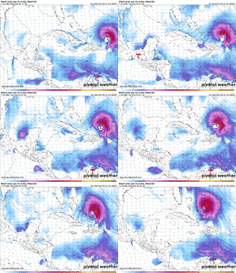
^Here’s the animation of 96L on this 12Z UKMET run during the last couple of days of the run (I also see a very weak sfc low on those late maps moving W toward NE FL. I wonder if that’s real.):
View attachment 197595
Is the UKMET the farthest west track at the moment? That's a lot closer than I was expecting.
 
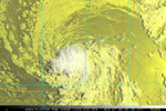
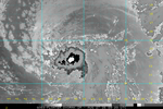
96L looks suspiciously like a TD on satellite. ASCAT doesn't support TD organization per NHC. I'm skeptical.

vis-animated.gif
 
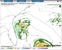
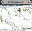
^Though not 96L, I’m posting the 168 hour sfc map of the 12Z UKMET here as a follow-up to my post just above to show that very weak low (1012 mb) moving W and approaching NE FL:

View attachment 197596

Not only did that preceding low appear on the 0Z UK, it is actually classified a TD on the 0Z at hour 108 in the subtropics and a TS at hour 132 on a WSW track ending not too far offshore E coast of FL on the way to a hit there on Sept 3rd as it is trapped by a strong SE H5 high:

NEW TROPICAL CYCLONE FORECAST TO DEVELOP AFTER 108 HOURS
FORECAST POSITION AT T+108 : 29.9N 72.3W

LEAD CENTRAL MAXIMUM WIND
VERIFYING TIME TIME POSITION PRESSURE (MB) SPEED (KNOTS)
-------------- ---- -------- ------------- -------------
1200UTC 31.08.2026 108 29.9N 72.3W 1014 25
0000UTC 01.09.2026 120 29.4N 72.3W 1011 30
1200UTC 01.09.2026 132 28.9N 72.4W 1007 35
0000UTC 02.09.2026 144 28.0N 73.7W 1005 37
1200UTC 02.09.2026 156 27.3N 75.6W 1005 38
0000UTC 03.09.2026 168 26.8N 77.3W 1003 37
IMG_2089.jpeg

Meanwhile, 96L is initialized as a TD, which is consistent with its 12Z run. Again, it remains a TD moving rapidly WNW in the MDR with a skimming of the N Leewards. It then becomes a TS but then it turns NW and NNW due to Fujihara around the preceding TS. It is on the image I posted above to the E of the preliminary low as it is Fujihara’d NNW and is weaker than the TS on the way to FL:

TROPICAL CYCLONE DEVELOPED IN THE MODEL ANALYSIS AT POSITION : 14.1N 33.5W

LEAD CENTRAL MAXIMUM WIND
VERIFYING TIME TIME POSITION PRESSURE (MB) SPEED (KNOTS)
-------------- ---- -------- ------------- -------------
0000UTC 27.08.2026 0 14.1N 33.5W 1011 29
1200UTC 27.08.2026 12 13.8N 37.1W 1010 29
0000UTC 28.08.2026 24 14.2N 41.5W 1010 29
1200UTC 28.08.2026 36 14.4N 46.4W 1011 31
0000UTC 29.08.2026 48 15.1N 50.8W 1011 29
1200UTC 29.08.2026 60 16.0N 54.9W 1012 32
0000UTC 30.08.2026 72 16.8N 58.5W 1012 30
1200UTC 30.08.2026 84 18.2N 61.9W 1012 32
0000UTC 31.08.2026 96 19.3N 64.9W 1011 30
1200UTC 31.08.2026 108 20.8N 67.1W 1011 31
0000UTC 01.09.2026 120 21.9N 68.8W 1011 29
1200UTC 01.09.2026 132 22.5N 70.0W 1009 30
0000UTC 02.09.2026 144 23.6N 70.4W 1007 32
1200UTC 02.09.2026 156 25.5N 70.9W 1007 36
0000UTC 03.09.2026 168 27.2N 71.6W 1008 37

Complications like this fascinate me as they make the forecasting much more difficult, which makes for more interesting forecast discussions.
 
35 kts/40 mph

AL, 96, 2026082712, , BEST, 0, 135N, 376W, 35, 1007, LO, 34, NEQ, 50, 0, 0, 0, 1012, 180, 50, 0, 0, L, 0, , 0, 0, INVEST, S, 0, , 0, 0, 0, 0, genesis-num, 011,
 
It organized pretty steadily last night and looks as good if not better than any other named storm this year
This system is getting better organized. It looks to be developing a circulation that is actually surrounded with clouds unlike the other "tropical storms" we have seen this year. If it can fight off the shear over the Atlantic it might have a chance to become something of interest for folks along the Southeast coast.
 
I don’t see it, she will get shredded.
Remaining weak is what gives this system a chance to be a threat down the road. If it had taken advantage of the environment it was in, it would certainly have recurved. Whatever is left of 96L will need to be watched once it approaches the Bahamas or NW Caribbean.
 
Too late @Wild Weather Monger
Special Message from NHC​
Thu, 27 Aug 2026 14:08:03 +0000​
NHC will initiate advisories on Tropical Storm Dolly (formerly AL96) located in the central Tropical Atlantic, at 1100 AM EDT (1500 UTC).
 
This system is getting better organized. It looks to be developing a circulation that is actually surrounded with clouds unlike the other "tropical storms" we have seen this year. If it can fight off the shear over the Atlantic it might have a chance to become something of interest for folks along the Southeast coast.
And this is the winner of the thread. NHC is issuing advisories at 11am
 
Back
Top