WAD declared, AGAIN!
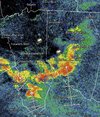
Severe thunderstorms are moving through the Sandhills early Monday morning, prompting a WRAL Weather Alert Day.

www.wral.com
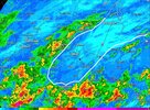
The National Weather Service in Raleigh has issued a
* Severe Thunderstorm Warning for...
Southeastern Moore County in central North Carolina...
Southwestern Harnett County in central North Carolina...
Western Cumberland County in central North Carolina...
Hoke County in central North Carolina...
* Until 630 AM EDT.
* At 537 AM EDT, severe thunderstorms were located along a line
extending from 7 miles east of Aberdeen to near Raeford to Antioch,
moving northeast at 30 mph.
HAZARD...60 mph wind gusts and nickel size hail.
SOURCE...Radar indicated.
IMPACT...Expect damage to roofs, siding, and trees.
* Locations impacted include...
Fayetteville, Southern Pines, Raeford, Fort Bragg, Aberdeen,
Antioch, Pope AAF, Hope Mills, Spring Lake, and Rockfish.
PRECAUTIONARY/PREPAREDNESS ACTIONS...
For your protection move to an interior room on the lowest floor of a
building.
&&
LAT...LON 3484 7926 3498 7929 3512 7943 3534 7911
3524 7887 3495 7891 3492 7897 3495 7904
3483 7919
TIME...MOT...LOC 0937Z 234DEG 27KT 3511 7930 3503 7921 3489 7918
HAIL THREAT...RADAR INDICATED
MAX HAIL SIZE...0.88 IN
WIND THREAT...RADAR INDICATED
MAX WIND GUST...60 MPH
$$
Kren
WERE COOKED.