The op euro is probably too high but I'm impressed by the 6 inch eps mean across much of the state.


I get it that the euro and it's ensembles look so juicy and we all need that to be right. However I look at the 3k nam and I'm seeing that familiar trend of backing off of my totals. The 3k says my 80% pops on Thursday are gonna need revising. This is through 60hrs.The op euro is probably too high but I'm impressed by the 6 inch eps mean across much of the state.
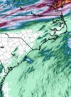
My concern would be this verifying south of models not north. The initial big convective band should push out a nice OFB and help the front get farther south than modeled, we do this every time. I would think your area would be more likely to over perform than under.I get it that the euro and it's ensembles look so juicy and we all need that to be right. However I look at the 3k nam and I'm seeing that familiar trend of backing off of my totals. The 3k says my 80% pops on Thursday are gonna need revising. This is through 60hrs.View attachment 196935
I'm a big fan of seasonal trends and this year has been to reduce pops and totals as we approach go time. That has to break at some point and maybe this is the one.My concern would be this verifying south of models not north. The initial big convective band should push out a nice OFB and help the front get farther south than modeled, we do this every time. I would think your area would be more likely to over perform than under.

I'm a big fan of seasonal trends and this year has been to reduce pops and totals as we approach go time. That has to break at some point and maybe this is the one.

Where are you at for July? Over 7 now2.26
7.86. Its not impossible I double my ytd, if things get crazy I could actually double my last 12 monthsWhere are you at for July? Over 7 now

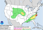
Excessive Rainfall Discussion
NWS Weather Prediction Center College Park MD
346 PM EDT Tue Jul 21 2026
Day 3
Valid 12Z Thu Jul 23 2026 - 12Z Fri Jul 24 2026
...THERE IS A MODERATE RISK FOR EXCESSIVE RAINFALL OVER PORTIONS
NORTH CAROLINA...
...Southeast...
21Z update... The heavy rainfall mentioned for the Day 2 period
will persist across North Carolina and surrounding locations as the
tropical moisture continues to interact with the stalled frontal
boundary. Training/repeating of storms will focus an additional 2
to 4+ inches over North Carolina and portions of southern/southeast
Virgina bringing the 48-hr forecast of 4 to 9+ inches for the
region. There will likely be a fair amount of overlap in the QPF
footprint from the D2 period, which will already be well saturated
prior to this period. A Moderate was also raised central and
east/northeast North Carolina as scattered to widespread instances
of flash flooding is expected.
The stalled out front that has remained across the Southeast will
continue to plague the area with very heavy rainfall, as the
continuous stream of Gulf moisture from the Gulf funnels
northeastward along the front. Yet another day of heavy rain is
expected to impact the Carolinas as a result. The front may drift
ever so slightly further south and east which should clear all but
the Hampton Roads area of far southeast Virginia from the heavy
rainfall threat by Thursday, but for much of eastern North
Carolina, much of South Carolina, and portions of northern Georgia,
generally from Atlanta east, the heavy rainfall threat will
continue through Thursday. Once again, potential for very heavy
rainfall totals in many areas as are expected to see heavy rain
from Wednesday could mean further upgrades to the risks may be
needed, especially across eastern North Carolina. Ultimately, where
the heaviest rain falls both today and Wednesday should dictate if
further upgrades will be needed.

Impressive! I'm over 3" for the month (can't recall exact amount and Tempest app is down or something). Anyway, haven't had 4"+ for a month since last July. Should pass that easily this month7.86. Its not impossible I double my ytd, if things get crazy I could actually double my last 12 months
I like your area tomorrow for huge totalsImpressive! I'm over 3" for the month (can't recall exact amount and Tempest app is down or something). Anyway, haven't had 4"+ for a month since last July. Should pass that easily this month
Probably will happen, I won't be here for it lol.I like your area tomorrow for huge totals
I did earlier when you said something. Amazing that the private sector breaks tooProbably will happen, I won't be here for it lol.
Btw anyone else having issues with Tempest app?
Not buying the rain and moist ground?There are a lot of 90s on the local tv 7 days early next week. Interesting
I didn't look hard enough the are some high 850s that get pulled in ahead of the next frontNot buying the rain and moist ground?
Didn't get below 80 last night
Feels like the front end of a tropical system outside this morning. I worry that the flood watch is going to be the KoD for usYeah walked out of work this morning and was like WTH was 82 at 7am....hot humid and windy. Now its just a matter of how much rain do we get, looks strange to see a flood watch after the dry start to the year.
I'm as skeptical as it gets on my rain chances and what the models show but damn man the DP doesn't go below 75 ever and there's so much moisture flowing onshore I can't see how we don't dump water in the setup.Feels like the front end of a tropical system outside this morning. I worry that the flood watch is going to be the KoD for us
That's how I feel but ive seen us fumble this before where the outflow pushes south of us and we just lose. Maybe this one will be differentI'm as skeptical as it gets on my rain chances and what the models show but damn man the DP doesn't go below 75 ever and there's so much moisture flowing onshore I can't see how we don't dump water in the setup.
We have a very solid SW wind cranking. Gut tells me fronts gonna have hard time crashing too far southThat's how I feel but ive seen us fumble this before where the outflow pushes south of us and we just lose. Maybe this one will be different


Lets hope so. There are a lot of bullseyes painted over my house on various products I don't want to be let down now. I did the math and I'm still over 18 inches BN in the last 12 monthsWe have a very solid SW wind cranking. Gut tells me fronts gonna have hard time crashing too far south

I rem when climo used to hold summer fronts back more than the models showed.That's how I feel but ive seen us fumble this before where the outflow pushes south of us and we just lose. Maybe this one will be different
Yeah this isn't a short term drought here. This is multi year stuff and I'm over 33 inches behind since the start of 2024Lets hope so. There are a lot of bullseyes painted over my house on various products I don't want to be let down now. I did the math and I'm still over 18 inches BN in the last 12 months
Looks like for most of us this will be Thur into Friday thing....looks like there will be several waves riding along the front so it will be off and on but when it is on the rain rates will probably be ridiculous. Good news is there is plenty of room in the creeks and rivers....I think the Tar at Greenville has been under 4-5 ft for months now.
Where’s the rain? Not a single drop yet in Mooresville
Sent from my iPhone using Tapatalk