packfan98
Moderator
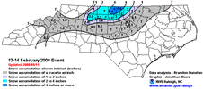
Valentine’s Day 2008 was something like this for the Triad IIRC? I know that was BirdMan’s favorite storm. And as someone who didn’t closely monitor weather back then (I’d start the next winter), that one seemed like it came out of nowhere. All of a sudden, my mom told me it was snowing and I look out and it’s pouring snow and we got a couple inches!I've seen these things work out before, but it'll be difficult. If we can get the changeover, we'll also need the surface temp to drop quickly to allow accumulations. We have nothing to lose.

Guarantee you this is one that WILL shift NW lolHere’s the RGEM trend. Looks like a Metwannabe Special to me. What do you think @RBR71 ???
View attachment 193453
methinks it will continue just a little moreGuarantee you this is one that WILL shift NW lol
I mentioned this yesterday in the pattern thread, but we do have a few positives for this one that we usually don’t have for these kinds of marginal BL events:
1. Soil temps will be lower the is typical, which will help the snow to stick more quickly than they would otherwise with a marginal BL.
2. At the moment, the timing of this seems to be after sunset, and certainly not around midday. It’s one thing to get 33-degree snow at night, but quite another to get that to stick during midday.
3. At least in shady spots, this could be a snow on snow situation, which is both unique and also will greatly aid in accumulations.
Basically, snow should stick more quickly than it usually would in this situation, and this is a situation where we don’t want to waste a tenth on getting the snow to stick given we may not have much to work with.
Definitely favoring a border county event right now, maybe mood flakes in the Triangle. The RGEM has my interest fully piqued, just need to get a little shift south. Probably won’t get it and it wouldn’t surprise me if it shifts in the other direction. Roxboro should be excited, could easily be another warning criteria event for them.
Euro is trying for RDU redemption…
View attachment 193461
Its just 2 days away, not 1018z AIFS Ensembles beefed up.
View attachment 193470
Good to have the Euro showing the highest totals. I think it's been bouncing back and forth pretty bad with winter storm threats, though.Euro is trying for RDU redemption…
View attachment 193461
Pretty impressive trend
Like I said...
View attachment 193495
Wow, Eastern NC continues to outsnow Western NC unless you go above 3500 feet. Pretty remarkable over the past few years.Final tally from the RGEM
View attachment 193447
