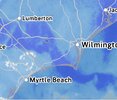
Storm totals thread or you don't mind
-
Hello, please take a minute to check out our awesome content, contributed by the wonderful members of our community. We hope you'll add your own thoughts and opinions by making a free account!
You are using an out of date browser. It may not display this or other websites correctly.
You should upgrade or use an alternative browser.
You should upgrade or use an alternative browser.
Pattern NC Only Thread
- Thread starter SD
- Start date
Long range may look warmer for mid-month, but the first week of February will still be cold. This is my grid forecast:
Today
Sunny, with a high near 29. Wind chill values as low as 10. Northwest wind around 14 mph, with gusts as high as 23 mph.
Tonight
Clear, with a low around 11. Northwest wind 5 to 7 mph.
Monday
Sunny, with a high near 40. Wind chill values as low as 5. Northwest wind 3 to 6 mph.
Monday Night
Mostly clear, with a low around 22. Calm wind.
Tuesday
Partly sunny, with a high near 46. Calm wind becoming southwest around 5 mph.
Tuesday Night
A chance of rain, mainly after 1am. Mostly cloudy, with a low around 33. Chance of precipitation is 50%. New precipitation amounts of less than a tenth of an inch possible.
Wednesday
A chance of rain. Mostly cloudy, with a high near 45. Chance of precipitation is 50%.
Wednesday Night
A chance of rain and snow before 1am, then a chance of snow. Mostly cloudy, with a low around 25. Chance of precipitation is 40%.
Thursday
Mostly sunny, with a high near 38.
Thursday Night
Mostly clear, with a low around 22.
Friday
Mostly sunny, with a high near 47.
Friday Night
Mostly clear, with a low around 28.
Saturday
Sunny, with a high near 40.
It's funny when 47 looks warm, which is still below our coldest average high of the year, LOL.Long range may look warmer for mid-month, but the first week of February will still be cold. This is my grid forecast:
Today
Sunny, with a high near 29. Wind chill values as low as 10. Northwest wind around 14 mph, with gusts as high as 23 mph.
Tonight
Clear, with a low around 11. Northwest wind 5 to 7 mph.
Monday
Sunny, with a high near 40. Wind chill values as low as 5. Northwest wind 3 to 6 mph.
Monday Night
Mostly clear, with a low around 22. Calm wind.
Tuesday
Partly sunny, with a high near 46. Calm wind becoming southwest around 5 mph.
Tuesday Night
A chance of rain, mainly after 1am. Mostly cloudy, with a low around 33. Chance of precipitation is 50%. New precipitation amounts of less than a tenth of an inch possible.
Wednesday
A chance of rain. Mostly cloudy, with a high near 45. Chance of precipitation is 50%.
Wednesday Night
A chance of rain and snow before 1am, then a chance of snow. Mostly cloudy, with a low around 25. Chance of precipitation is 40%.
Thursday
Mostly sunny, with a high near 38.
Thursday Night
Mostly clear, with a low around 22.
Friday
Mostly sunny, with a high near 47.
Friday Night
Mostly clear, with a low around 28.
Saturday
Sunny, with a high near 40.
I totally agree. I was happy watching the snow last night but extremely frustrating day overall. I literally rode that line all day. Then closed in all around me. Kylog and I had areas getting pounded at one time just to our north, south, east and west.I'm much happier this morning than I was yesterday morning. That dry slot was a terrible thing to endure if you're a snow lover. Just because of that, I didn't like this storm. I ended up fine with the snow, but the storm tracking the last few days sucked, and again the dry slot was unbelievable. Usually I would rank a storm like this a B+ or A-. But it barely gets a C because of the headaches.


y’all can blame RCRaleigh is going to get at least 10". I just wouldn't worry about it at this point. It's going to snow and snow big. Just enjoy it.

Saw a tweet
"Its so cold out, I saw a politician with his hands in his own pocket"
Theres yall one for the water cooler talk tommorow !
And Im pressuming this is real, not doctored . they did get a lot of snow, and seas where whipped up no doubt.

"Its so cold out, I saw a politician with his hands in his own pocket"
Theres yall one for the water cooler talk tommorow !
And Im pressuming this is real, not doctored . they did get a lot of snow, and seas where whipped up no doubt.
Folks with snow cover should step outside this evening. The moonshine is beautiful.
Btownheel
Member
It really is
Sent from my iPhone using Tapatalk
Sent from my iPhone using Tapatalk
Not sure how we are going to make 9 tonight. RDU was 24 at midnight!
southernskimmer
Member
- Joined
- Dec 14, 2016
- Messages
- 63
- Reaction score
- 137
My parents live in Holden - this is most definitely real, they measured 15 inches in their neighborhood. They sat under this band for hours last night.Saw a tweet
"Its so cold out, I saw a politician with his hands in his own pocket"
Theres yall one for the water cooler talk tommorow !
And Im pressuming this is real, not doctored . they did get a lot of snow, and seas where whipped up no doubt.
View attachment 193349
Attachments
a_gilmore88
Member
A bit disappointed with my low temp tonight. I thought we may challenge my personal all time low temperature record for this location at 5°. Not even close…sitting at 14° at 6:15 am. Bummer!
1- 2 degrees at 5:20 when I left this a.m.. Car themometer pinged between 1-3 all the way up to Gboro. Was 9 when I got out of car.
Several rural areas are gonna hit 0 by sunrise, perhaps dipping negative. Nice cold snowy winter a.m. under the Full moon.
Several rural areas are gonna hit 0 by sunrise, perhaps dipping negative. Nice cold snowy winter a.m. under the Full moon.
packfan98
Moderator
3 degrees here! 
5 here
WolfpackHomer91
Member
9 Here idk why
a_gilmore88
Member
We bottomed out at exactly the same temperature we did on Sunday morning, 10.4°.
NCWeatherhound
Member
3 degrees this morning in Lumberton and Chadbourn. 4 in Hoke Co. The snowpack really did its job.
Made it down to 12, so that's lower than I expected, all things considered.Not sure how we are going to make 9 tonight. RDU was 24 at midnight!
wow
Member
Bottomed out at 3.9 here. Looks like Alaska out there.
Wednesday afternoon is going to turn into something at this rate
RGEM looks "interesting", to say the least.Wednesday afternoon is going to turn into something at this rate
Yep pretty wet which is following the nam. Not sure how far S of 40 the good cold can get. Id be pumped in your location. Sleet snow snow in less than 14 daysRGEM looks "interesting", to say the least.
another beautiful view today

10 this morning, still no single digits here
Cad Wedge NC
Member
That picture from Beech Mtn is absolutely beautiful.
tazaroo
Member
Ski slopes have been doing awesome this year. Sorry for the Rockies but ours deserve some love after all these hot winters. These "old" bones are going in a few weeks.
- Joined
- Jan 23, 2021
- Messages
- 4,603
- Reaction score
- 15,199
- Location
- Lebanon Township, Durham County NC
Always good to be home. Noticed on the train there’s still a ton of snow through Ktown, Salisbury and Lexington.

43 today felt like 80
Is the next 5-6 days in NC / winters last stand? Can never really say. All I see after we get through this weekend is run of the mill wx with temps in the 50's, progressing next week. If we don't get a PV displacement. I think we just end up riding it on out seasonal and into spring. I usually wait till mid Feb, look hard for pattern recognition the last 2 weeks of Feb, then throw the towel in at that point.
It's been 70 days since Thanksgiving.
Greensboro has been below normal temps 45 out of those 70 days
Greensboro has been below normal temps 45 out of those 70 days
Wilkes County today. This is a driveway up to a house. I call it heavenly living.

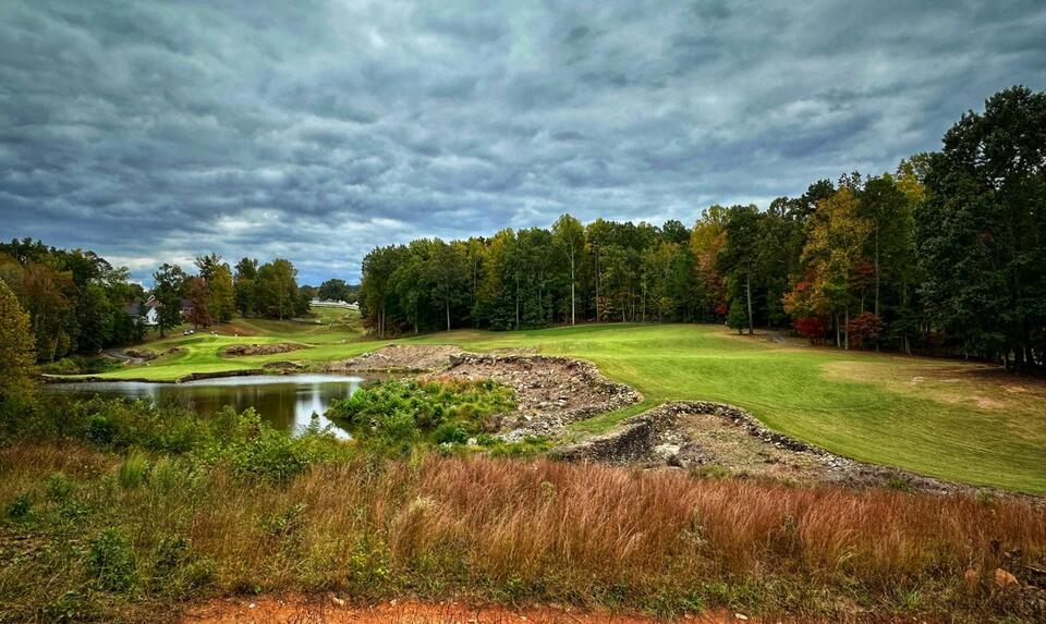
Heres this years top 25 public golf courses in NC. Played and done some killer sledding on # 4 Tot Hill Farm. Highly reccomend. Mike strantz designed, rated 7th hardest course in Golf digest one year. Spectacular beauty. He also designed Tobbaco Road,#5.
 share.newsbreak.com
Best 25 Public Golf Courses in North Carolina - Golfers' Choice 2026 - NewsBreak
According to magazine rankings, the question of the best public golf course in North Carolina has been relatively well-settled over the years. But what do
share.newsbreak.com
Sciadopitys2
Member
Strantz was an artist. Crystal Coast CC being on that list is.......interesting.
Btownheel
Member
Heres this years top 25 public golf courses in NC. Played and done some killer sledding on # 4 Tot Hill Farm. Highly reccomend. Mike strantz designed, rated 7th hardest course in Golf digest one year. Spectacular beauty. He also designed Tobbaco Road,#5.
Best 25 Public Golf Courses in North Carolina - Golfers' Choice 2026 - NewsBreak
According to magazine rankings, the question of the best public golf course in North Carolina has been relatively well-settled over the years. But what do
So……..many….boulders. And I flat drilled my share when we played there.
Sent from my iPhone using Tapatalk
It was cold evening of baseball practice in Pittsboro. We had some light graupel falling on us around 5:45pm
WolfpackHomer91
Member
If there's anyone in or close in proximity to Salisbury.... How are the roads?
My oldest son goes to Rowan Schools they’ve been out two weeks but go back tomorrow. I’d say you get around Salisbury you’re prob fine on Innes / Jake ect
Sent from my iPhone using Tapatalk
I'm about 35 miles north of Salisbury on the west side of Winston. I can't speak to the roads there; but here all the main roads here are just fine. Most of the side roads are fine. In some neighborhoods with steeper streets, you still have some icy patches that can be dangerous. With the freeze/thaw, travel in the afternoon is several orders of magnitude better than early morning or after dark. Our roads were very icy early this morning after the melt refroze overnight. They were fine this afternoon.If there's anyone in or close in proximity to Salisbury.... How are the roads?
Take that for what it's worth. I wanted to give you some idea of what it's like up here now. That could change in a few days for the better. On my own, tomorrow I wouldn't hesitate to travel to Salisbury in the day. Your mileage may vary depending on your destination.
My oldest son goes to Rowan Schools they’ve been out two weeks but go back tomorrow. I’d say you get around Salisbury you’re prob fine on Innes / Jake ect
Sent from my iPhone using Tapatalk
Appreciate it, Wolfpack and Gator.I'm about 35 miles north of Salisbury on the west side of Winston. I can't speak to the roads there; but here all the main roads here are just fine. Most of the side roads are fine. In some neighborhoods with steeper streets, you still have some icy patches that can be dangerous. With the freeze/thaw, travel in the afternoon is several orders of magnitude better than early morning or after dark. Our roads were very icy early this morning after the melt refroze overnight. They were fine this afternoon.
Take that for what it's worth. I wanted to give you some idea of what it's like up here now. That could change in a few days for the better. On my own, tomorrow I wouldn't hesitate to travel to Salisbury in the day. Your mileage may vary depending on your destination.