-
Hello, please take a minute to check out our awesome content, contributed by the wonderful members of our community. We hope you'll add your own thoughts and opinions by making a free account!
You are using an out of date browser. It may not display this or other websites correctly.
You should upgrade or use an alternative browser.
You should upgrade or use an alternative browser.
Wintry Machine Learning Mauler 1/30-2/1
- Thread starter SD
- Start date
Those are impressive images burrell. What did you see on radar? Guess it was just a heavy band? Did it kind of form right on top of you?I wish I could describe to you guys what that snow squall was like yesterday. I’ve got some theories on why it was so instense at my location. But I think these pictures do it justice.
In picture 1: you are looking at the end of my driveway/treeline which is 120 yards away during the most intense snowfall from the main band, the meat of of the storm, I would have described this as heavy snow.. it produced more than one inch in an hour and this was the heaviest part of it. Video taken at 10:35am, notice how bright it is.
In picture 2 and 3: you’re looking at the same exact location at the end of my driveway, 120 yards away. This was during the squall… it was insane! Also had 40mph gusts, and almost black out dark conditions at 12:05pm. It was complete weenie euphoria for me.
View attachment 193287View attachment 193288View attachment 193289
I'd say we've got about 95% snow coverage still on non-paved surfaces. The exceptions are south facing hills that are under trees...I guess a lot of snow got caught up in the trees above and so the areas underneath the trees had less snow. Pretty interesting even though it was a dry snow. Roadways are hit-and-miss. Treated roads tend to be okay, but the untreated roads are snowy/icy in shaded areas. It will certainly be icy in the morning.
Pretty sure we are going to lose a lot of sunny spots tomorrow.
Pretty sure we are going to lose a lot of sunny spots tomorrow.
rburrel2
Member
It was a very thin band on radar, but it was racing really quickly from northeast to south west. I think it had something to do with the just above the surface convergence zone that manifested as a result of the meso low stuff that cranked around the mountain chain.Those are impressive images burrell. What did you see on radar? Guess it was just a heavy band? Did it kind of form right on top of you?
Those streamers that developed over the upstate later on were sorta mini-low level convergence zones/bands… but I was in-between the development of those two bands and basically it was sorta like an exploding “bow echo” that pushed out before forming the bands on either side. So it lasted only a couple minutes for me but it was extremely intense, specifically at the surface/low levels. To where the more stationary bands formed on each side of it lasted hours, but weren’t as intense.
That’s my theory anyways.
- Joined
- Jan 23, 2021
- Messages
- 4,603
- Reaction score
- 15,199
- Location
- Lebanon Township, Durham County NC
Hung onto almost all of our snow cover
I want to post the storm progression before this one goes into the vault. Our kids kids kids may need to look back to find the analog one day 


Webberweather53
Meteorologist
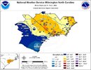
My preliminary analysis for this storm over NC.
Hopefully, I can find some time later this week to knock out SC, because this literally took me all day to do
Thanks for all the reports everyone.

Hopefully, I can find some time later this week to knock out SC, because this literally took me all day to do
Thanks for all the reports everyone.
a_gilmore88
Member
My preliminary analysis for this storm over NC.
Hopefully, I can find some time later this week to knock out SC, because this literally took me all day to do
Thanks for all the reports everyone.
View attachment 193329

Amazing work, as always. Thank you for doing one of these!

Updated totals map from ILM. That 16" is Tabor City. Looks like Loris came in at 14" and it drops off quickly south from there. Out here slightly further west that 14" seems reasonable but measurement was difficult.
Attachments
Drove to Asheboro last night to see around 10”, Siler City was hit good too. We had around 3” in NE Chatham.

tazaroo
Member
I took a drone video of and around my house and neighborhood. We picked up right at 12in before the compacting. Just a little more than Asheboro itself 4 miles South of me. I know other states are involved so sorry for the biased name lol.
WxBlue
Meteorologist
What's remarkable is that every single NC county saw at least 3 inches of snow somewhere... and we were close on getting that number up to 4 inches (Harnett County and Gates County didn't make it).
My pleasureWhat's remarkable is that every single NC county saw at least 3 inches of snow somewhere... and we were close on getting that number up to 4 inches (Harnett County and Gates County didn't make it).
Peaceful winter’s evening.

I took a drone video of and around my house and neighborhood. We picked up right at 12in before the compacting. Just a little more than Asheboro itself 4 miles South of me. I know other states are involved so sorry for the biased name lol.
Great job. I enjoyed that neighbor. Uwharries are beatifull. Not the blue ridge, but as close as you can get without being there. Stole a screenshot from your video.

tazaroo
Member
Great job. I enjoyed that neighbor. Uwharries are beatifull. Not the blue ridge, but as close as you can get without being there. Stole a screenshot from your video.
Thanks, that's one of the I reasons I chose this location. Love the mountain look. Its Back Creek Mountain. The Northern most section of the Uwharrries along with Caraway.
WxBlue
Meteorologist


My forecast vs. my verification. Honestly, I did better than I expected.

CNCsnwfan1210
Member


Photo dump of riding through western Wilson county this morning
Sent from my iPhone using Tapatalk
LukeBarrette
im north of 90% of people on here so yeah
Meteorology Student
Member
2024 Supporter
2017-2023 Supporter

Look what I found LOL. On the 18th of Jan predicting this storm
CNCsnwfan1210
Member
View attachment 193384
Look what I found LOL. On the 18th of Jan predicting this storm

Here’s the H5 pattern as the storm was well underway
Sent from my iPhone using Tapatalk
LukeBarrette
im north of 90% of people on here so yeah
Meteorology Student
Member
2024 Supporter
2017-2023 Supporter
 Going through old threads as I'm making a presentation for the Forecasting Club at VT and well this is wild from the GFS AI. Off on timing but looks very similar
CNCsnwfan1210
Member
My preliminary analysis for this storm over NC.
Hopefully, I can find some time later this week to knock out SC, because this literally took me all day to do
Thanks for all the reports everyone.
View attachment 193329
Thanks Eric, you do a superb job documenting these winter storms along with your analysis. Also, thanks for your hard work in putting this together gathering snowfall reports from around the state. This storm will be remembered for many many years to come.
Sent from my iPhone using Tapatalk
Sctvman
Member
Yeah when I was toggling wundermaps last night it looked rather cold that way. Probably broke a lot of records last night. This one caught my eye

This jibes well with these near record low 0C 850s going way out in the Gulf and nearly to Cuba:
Euro

UKMET

my immediate take is that there's not a chance in hell any model was going to nail this. the two trends i noticed in the leadup were the raleigh hole as well as down east getting clobbered. for everything else it was 4-8, localized foot, let the cards fall where they mayMy preliminary analysis for this storm over NC.
Hopefully, I can find some time later this week to knock out SC, because this literally took me all day to do
Thanks for all the reports everyone.
View attachment 193329
2 more have fallen into the Atlantic this morning
The UKMet had an awful performance with this storm over the 5 day lead up
BrickTamland
Member
Euro did a great job catching the potential in the long range. All the globals and NAM pretty much sucked with specific totals more than a couple of days out, and even then the Euro was the only one close to what happened. The HRRR and 3K NAM did a good job with the dry slot showing 12 to 24 hours out.
- Joined
- Jan 23, 2021
- Messages
- 4,603
- Reaction score
- 15,199
- Location
- Lebanon Township, Durham County NC
The UKMet had an awful performance with this storm over the 5 day lead up
I’d even say historically awful.
Did Florida get those ocean effect snows they were talking about?
Tampa did!
Definitely saw flurry reports around Tampa and down in Naples. Not sure anywhere got legit snowfall rates, but still a rarity down there.Did Florida get those ocean effect snows they were talking about?
Makeitsnow
Member
It did get the snow band in Georgia right...other than that though it was bad.I’d even say historically awful.
House on the street behind me with icicles hanging down, looking like the 1960’s

Losing a lot of south-facing hills to the sun today. RIP.
House sits near a tall tree canopy and the north face is holding strong. Still 3-4” here 