BlueRidgeFolklore
Member
Hendersonville is getting smoked right now. I assume you mean Henderson?Look at the vast area of dryness!! From Wilmington to Raleigh to Hendersonville.
Hendersonville is getting smoked right now. I assume you mean Henderson?Look at the vast area of dryness!! From Wilmington to Raleigh to Hendersonville.
Snow that keeps on snowing. Relentless and will noticeably add to your totalsIt’s coming straight for me what can I look forward too
Sent from my iPhone using Tapatalk
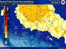
I think Spider-Man needs some more legos or he going to disappear lol9 legos deep. Approaching 7” in Randleman. Currently 1.25” per hour rates. Just incredible.
View attachment 192819
Been since 1989 Charleston has had two straight winters of measurable snow. Now we have
Mitch is about to have a pizza party on his roof.Columbia finally getting real snow. Pouring Big fat flakes and almost white out conditions
My yard is finally covered and road is getting covered now
I'm thinking a small deformation band has parked itself over m6 location. Still pouring down.Holy cow, I think yall got some localized banding luck because we do not have that here.

I saw one earlier on Radarscope. Pretty cool stuff!!I'm thinking a small deformation band has parked itself over m6 location. Still pouring down.
I just want to get under one heavy return before it gets dark. Lol!that band coming in from Lumberton and Laurinburg looks like it’ll be the real deal
I think the absolute highest measurements will be somewhere in Davidson Rowan or Randolph county

Yeah, this one was a good ole kick in the…

Eric - Can't wait to see your final snowfall map.


Long as we’ve been posting together, I really feel for you and @RBR71I just want to get under one heavy return before it gets dark. Lol!

You think that’ll reach us in Durham Co? I sure hope so!that band coming in from Lumberton and Laurinburg looks like it’ll be the real deal

 still pounding
At a foot currently in southern Rowan. Still hammering.I can’t wait either, this is a truly landmark storm for the Charlotte area. Some places along the 85 corridor (esp in Rowan & Davidson counties) are getting nearly as much or even more snow than they did in the historic Feb 2004 snowstorm
View attachment 192834
It’s tilting in exactly the way you want to see. I think it will.You think that’ll reach us in Durham Co? I sure hope so!
It'll be like this throughout the evening hours as well.Columbia finally getting real snow. Pouring Big fat flakes and almost white out conditions
My yard is finally covered and road is getting covered now
 ️
️