NBAcentel
Member
The 06z ICON is headed towards another crushjob, similar to the 00z run.

The 06z ICON is headed towards another crushjob, similar to the 00z run.

But it’s strange how most other modeling makes it work with both except for the NAMs. Something to keep a eye on I guess


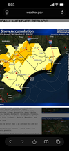
I’m more concerned the NAM is firing warning shots and losing some of the ULL and turning this more into a coastal.GFS has had significant movements with the coastal but has remained pretty steady on the ULLView attachment 191647
NAM is on an island. Not sure if coastal & ULL type stuff is in its wheel house either. I respect the NAM more so with sniffing out a warm nose in an overrunning event. But if it shows it again mid morning, it’ll have my attention more. It’s going back & forth currently.I’m more concerned the NAM is firing warning shots and losing some of the ULL and turning this more into a coastal.

Looks like more of a shift or the dry a lot forming further west over my area. I guess this has always been a possibility, especially if we lose some of the ULL influence.
I think it’s always been in the table. I can remember storms doing this when the energy transfers to the coastal.GFS AI figuring out Coastal, but it’s taking moisture from the West. It would suck if some how at the last day these two features figure out a way to NOT coexist.View attachment 191651
The biggest development I see is the surface low is now forming along the Gulf Stream where an incredible baroclinic zone resides between the Arctic air mass and the warm water there.Looks like more of a shift or the dry a lot forming further west over my area. I guess this has always been a possibility, especially if we lose some of the ULL influence.
GFS AI figuring out Coastal, but it’s taking moisture from the West. It would suck if some how at the last day these two features figure out a way to NOT coexist. Gonna need this movement to stop next cycle. View attachment 191651


Yeh man, but shifts like this scare the weather family on the Southern flank of this. I am sure it's got NC grinning. But anyways, I am to emotionally involved in this one for a rug pull so my negativity is oozing to the surface a bit.I personally think we are fine. If other short term modeling head towards the NAM then I can understand the worry, but the NAM hasn’t been consistent at all, and it’s already been known to be lackluster QPF wise in the past, badly in some casesView attachment 191654View attachment 191655

I personally think we are fine. If other short term modeling head towards the NAM then I can understand the worry, but the NAM hasn’t been consistent at all, and it’s already been known to be lackluster QPF wise in the past, badly in some casesView attachment 191654View attachment 191655
Yea if the Nam leads the way SC is hosed...Will have to watch Rdu get buried again while we get a dusting...typical ULL stuff in nw sc. I think you good either way thoNot to try to wake everyone up with bad vibes. Hopefully the Euro & AI hold serve here shortly.


Yeah not sure what that's about. Rgem and 3k still give me a good hit.Both the Euro and GFS have a minima of around .11 qpf around Wilmington, NC. Ouch.


Both the Euro and GFS have a minima of around .11 qpf around Wilmington, NC. Ouch.


No. More like 1-2”. The further east areas won’t be getting as high ratios as areas further west.That can still wind up as 7-8”.
For sure. I'm not sure I buy that maxima around Raleigh at the expense of the coastal precip shield. It's clearly on the table though. What's weird is the NC tidewater seemed like the safest place for 6+ inches... and all of a sudden it's not.That can still wind up as 7-8”.