mudaddict
Member
Must be the lightest snow ever back in middle tn... shows snow there for 18hrs and only 1 inch..ill be happy with any amount though0Z 3K NAM KucheraView attachment 191513
")
Must be the lightest snow ever back in middle tn... shows snow there for 18hrs and only 1 inch..ill be happy with any amount though0Z 3K NAM KucheraView attachment 191513
HRW-WRF-NSSL is basically the opposite of the NAM 3km with very patchy and light anemic precip returns, but instead the snow totals are much higher3KM NAM reflects these super impresssive precip shields then output the most unimpressive QPF totals. It's really weird.


How would you rank them in reliability
I've been looking into what makes up the NBM, I was surprised that it uses old data, the 18z was using the 0z Euro ens individual members for instance. It also uses a ton of bad models at range, like the NAM nest cams, the RAP, and the HRRR for 42 hr 6hr snowfall for instance. It doesn't use the OP Euro at all that I could find.Super confused by this as well. I would expect the National Blend of Models to more or less reflect the models I see, but it often doesn’t seem to. Also, what is the difference between the NBM and the Parallel NBM?
“Nowcasting” a ULL dropping down from the north is the king of all nowcasting hallucinations. You swear it’s going west, then you swear it’s going south, only to find out it was a wobble. Lol!IMHO - “Nowcast” seems to be overused quite a bit with systems, but with this storm…we can expect that things change frequently up to and throughout the event. These are fairly dramatic jumps for specific locations run to run regardless of models.
I kind of have a hunch the models are slowly seeing this process. Instead of a typical north trend, we will see the models continue with a west trend, pulling the low closer to the coast. This should bring the heavier precip further west, similar to Jan 2000. Of course, this only happens if the better west trend of the upper low and more negative tilt continues.Damn thats actually eerily similar to the instant occlusion of Jan 2000, just further south

Outdated info, @bouncycorn can shed light on this and has numerous times actually. My understanding it does include all globals, CAMS and if I'm not mistaken NWS models or data that is not readily available to the public. But the reason it gets so much attention is NWS offices mention it often in their AFD and rely heavily on in for their forecastI've been looking into what makes up the NBM, I was surprised that it uses old data, the 18z was using the 0z Euro ens individual members for instance. It also uses a ton of bad models at range, like the NAM nest cams, the RAP, and the HRRR for 42 hr 6hr snowfall for instance. It doesn't use the OP Euro at all that I could find.
All modeling shows me with 3 to 5 inches as of 18z. The NBM shows me with 1/2 inch. It's a very odd tool and the NWS here seems to rely on it exclusively to make their forecast.

At 12z runs tomorrow…3km will carry more weight with me. Then probably NAM. I havent used the FV much.How would you rank them in reliability
What is this? Genuinely have no clue what model this is.HRW-WRF-NSSL is basically the opposite of the NAM 3km with very patchy and light anemic precip returns, but instead the snow totals are much higher
View attachment 191524
View attachment 191525
The FV3 in summer can overblown convection, once in awhile it does well.At 12z runs tomorrow…3km will carry more weight with me. Then probably NAM. I havent used the FV much.
Absolutely smoked

You can look at the NBM Dashboard. It lists no OP Euro that I see, and 0z Euro ens members, and 6z GEFS ens members for 18z.Outdated info, @bouncycorn can shed light on this and has numerous times actually. My understanding it does include all globals, CAMS and if I'm not mistaken NWS models or data that is not readily available to the public. But the reason it gets so much attention is NWS offices mention it often in their AFD and rely heavily on in for their forecast
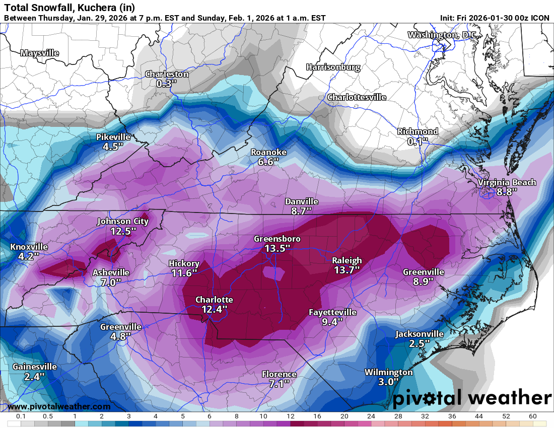
Best ICON run by far.
Absolutely smoked
Absolutely smoked
Its still going. Also, its lying.Best ICON run by far.
.png")
.png")
That’s just a thing of beauty right there. We just don’t see that look very often in the south.The RGEM might be trying to pull a rapid occlusion East of Charleston this time.
View attachment 191534
A 978 off Lookout?The RGEM might be trying to pull a rapid occlusion East of Charleston this time.
View attachment 191534
View attachment 191535

On hr 48, it actually popped a new low east of Charleston after having one further north off ILM. Cyclonically looped.A 978 off Lookout?
It was also severely outdated last storm. It kept showing 6-8 inches of snow over me long after all models that are actually useful showed the warm nose/ice meant no shot of that. It took 3 to 4 cycles for the NBM to actually catch up. Using that old data really holds it back. Wild that the 18z today was using the 0z Euro ens.Outdated info, @bouncycorn can shed light on this and has numerous times actually. My understanding it does include all globals, CAMS and if I'm not mistaken NWS models or data that is not readily available to the public. But the reason it gets so much attention is NWS offices mention it often in their AFD and rely heavily on in for their forecast


