Not to be measured in a drift! Just to put that out there!If Charlotte area gets a foot or more I’ll donate $1k to the site!
-
Hello, please take a minute to check out our awesome content, contributed by the wonderful members of our community. We hope you'll add your own thoughts and opinions by making a free account!
You are using an out of date browser. It may not display this or other websites correctly.
You should upgrade or use an alternative browser.
You should upgrade or use an alternative browser.
Wintry Machine Learning Mauler 1/30-2/1
- Thread starter SD
- Start date
iGRXY
Member
UK looks better thru 39

You shot your shot and I respect it! More than I’m willing to do atm for my area!View attachment 191238
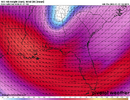
heres my snowfall confidence map for georgia for seeing an inch of snow, pink area: high/likely, purple area: 50/50 shot, blue area: unlikely but possible sorry its a bad map i know
Lowest snow total in all of NC outside the OBX and far SW corner of the state right over my house, love it.
View attachment 191225
I’m not saying I’m buying the gfs since it’s a poor model and has tended to overdo qpf and snow, but fwiw this shows FAY with one of their biggest snows on record with 12-15” in the area! Wow, that would be crippling.
Also, in case this were to somehow verify closely: when was the last time the entire NC got 5”+ from one storm?
Not to be forgotten, this gives me ~0.3”, a rare event down here!
Last edited:
- Joined
- Jan 23, 2021
- Messages
- 4,603
- Reaction score
- 15,199
- Location
- Lebanon Township, Durham County NC
1988? Maybe?I’m not saying I’m buying the gfs since it’s a poor model and has tended to overdo snow, but fwiw this shows FAY with one of their biggest snows on record with 12-15” in the area! Wow, that would be crippling.
Also, in case this were to somehow verify closely: when was the last times the entire NC got 5”+ from one storm?
Not to be forgotten, this gives me ~0.3”, a rare event down here!
If you could just move the eastern side of that east by 5 miles or so it would be great… lol. Seriously though I would not worry to much about the NAM’s output down east. The biggest reason is that it didn’t really follow the SREF. I know the SREF is horrible and I will never forgive it for February 2015 but it is typically good with its QPF footprint and when the NAM differs as much as it did, you know something is probably off.A strong upper low + mesolow is usually a winning combo for the Charlotte area down to about Spartanburg, SC and into the northern Midlands of SC.
View attachment 191197
View attachment 191199
If I was a snow weenie in the Carolinas right now, this is roughly where I’d want to be for this storm give/take based on what I currently see
View attachment 191201
Downeastnc
Member
I’m not saying I’m buying the gfs since it’s a poor model and has tended to overdo qpf and snow, but fwiw this shows FAY with one of their biggest snows on record with 12-15” in the area! Wow, that would be crippling.
Also, in case this were to somehow verify closely: when was the last times the entire NC got 5”+ from one storm?
Not to be forgotten, this gives me ~0.3”, a rare event down here!
1980 would be my guess

packfan98
Moderator
UKMET was a little flatter and weaker from what I saw.

iGRXY
Member
Base of the trough was west but + TiltedUKMET was a little flatter and weaker from what I saw.
Bigedd09
Member
UKMET was a little flatter and weaker from what I saw.
Resembles the rgem
Sent from my iPhone using Tapatalk
JDRwxNC
Member
hr78 - 12z GEFS not much give to what the fully extended NAM3km

UK blanks rdu and jackpots midlands lol
NWG_WX14
Member
At what point do we stop putting much thought with what the ensembles are showing?
Dunkman
Member
The Triad is over 7 years now without a 4” snow. Can we find a way to screw it up again? The UK says absolutely!
- Joined
- Jan 23, 2021
- Messages
- 4,603
- Reaction score
- 15,199
- Location
- Lebanon Township, Durham County NC
GEFS basically unchanged from 6z.
JDRwxNC
Member
Even when not favorable for your area, you don't. Its an incredibly valuable data point.At what point do we stop putting much thought with what the ensembles are showing?
If all of these drier models come true over the NC Piedmont, then the WthrNxt is going to drop a couple of tiers.
- Joined
- Jan 23, 2021
- Messages
- 4,603
- Reaction score
- 15,199
- Location
- Lebanon Township, Durham County NC
So what does it say when we know that the NAM(SREF) and GFS(GEFS) do not agree with their ensemble means?
Not only the UK, but the GFS and CFS have the Triad and RDU in a bad spot with lesser amounts. Let's hope this is not the beginning of a trend that the other models will pick up on. If I wanted to see maximum snow amounts based on this run, Wilmington would be the place to be.The Triad is over 7 years now without a 4” snow. Can we find a way to screw it up again? The UK says absolutely!


Latest Model Roundup Northern Randolph County (Asheboro-Greensboro)
7-11
Roofus
Icon
GFS
FV3
NBM Para
Sref
5-6
NAM
6Z Run of Euro AiFS
3-4
AI GFS
Canadian OP
1-3
RDPS
Ukmet
Best thing to root for besides earlier tilt, possibly a closer coastal to Myrtle Beach, with clean faster transfer. Would be ULL to travel from west to east further North just 35- 50 miles.
7-11
Roofus
Icon
GFS
FV3
NBM Para
Sref
5-6
NAM
6Z Run of Euro AiFS
3-4
AI GFS
Canadian OP
1-3
RDPS
Ukmet
Best thing to root for besides earlier tilt, possibly a closer coastal to Myrtle Beach, with clean faster transfer. Would be ULL to travel from west to east further North just 35- 50 miles.
pretty fair shift towards atlantaGEFS basically unchanged from 6z.
rburrel2
Member
Still has a few more adjustments to go before it lines up with euro/euro ai/gfs ai.
Bro you got to slow that down for us old eyes. I’m dayquilin/ nightquilin with my eyes over here!
UK has been in the spin cycle

Little more than half of the 12z GEFS members are west of the mean at 72hrs, with better clustering than the ICON ensemble at this period. I'd toss the double barrel surface look of the op GFS for the time being, but still something to keep an eye on. Often times this is just the models struggling where to place the dominant surface low, climo favors the barolcinic zone along the Gulf Stream, area of max delta T.

packfan98
Moderator
All of the european and AI models have been doing this. Seems like a new phenomenon. Makes it difficult to figure out trends.
LovingGulfLows
Member
- Joined
- Jan 5, 2017
- Messages
- 1,499
- Reaction score
- 4,100
just got a better look at GEFS and DANG that thang is jogging west
Really looks like the RGEM/Euro now from an upper level POV. 12z GEFS was the best run for my backyard yet. Still, the modeled totals are still oscillating on all the models so it's hard to say where it all ends. We're basically playing roulette at this point.
I honestly think it's not something that's too complicated. The tilt, track, and strength of the ULL has varied each run across every single model suite. One run, neutral tilt, stronger. Next run, negative tilt, weaker. Next run positive tilt, stronger, farther south. The snowfall maps reflect these very minor changes. You can watch the loops side by side with the snowfall output and easily see it. If we can get consensus around that, we'll have a good idea about the western areas. The eastern zones are going to be impacted by the handoff from the ULL to the coastal and the location at which the coastal bombs. I favor the Gulf Stream idea because of the heat flux and super duper cold core rotating over. Maybe that doesn't happen this way, but this seems most logical. That said, if we see convection all over the western Atlantic and lows forming all over the place, maybe that muddies the waters, and very little snow occurs in east-central areas. I don't see that, in the end. But it will be fun to watch unfold.All of the european and AI models have been doing this. Seems like a new phenomenon. Makes it difficult to figure out trends.
Sctvman
Member
Roads around where I am in CHS (James Island) already getting salted and that tells you what SCDOT thinks about this storm
FFC just expanded their WSW to Atlanta Metro
So what does it say when we know that the NAM(SREF) and GFS(GEFS) do not agree with their ensemble means?
Not much IMO.
This has been going on with the models where is seems the heavier precip stays at the border of Fannin and Gilmer counties and that makes no sense as this is not a CAD driven event. There is no terrain between here and there that would impede the precip from moving into this area. I think this will resolve in real time.Not sure why but all the models set up a really decent FGEN region over N GA but few actually drop heavy precip. GFS shows the lower 900 mb being slightly too dry. I'm wondering if it'll come in as a surprise or if there's some reason it's showing up like this. I'd think the NW winds against the mountains would stop the dry air when it's that low given the upper level tropical moisture inflow
BrickTamland
Member
I was thinking the same thing. Less than 48 hours out and the models have been changing a lot and still different from each other the last 12 to 24 hours.So instead of model consensus growing 48 hours out we have a continued war. Great
Brandon10
Member
the fact that if one camp is right, you get a dusting. If another camp is right, you get a foot. How do you even prepare for that other than prepare for the most? Sheesh. Poor forecasters.I was thinking the same thing. Less than 48 hours out and the models have been changing a lot and still different from each other the last 12 to 24 hours.
FFC just extended Winter Storm Watch to Atlanta (???)

YVille1128
Member
Well, that's why they get paid. I can sit on here and pick which models I want to follow. They are trained to do much more than watch models.the fact that if one camp is right, you get a dusting. If another camp is right, you get a foot. How do you even prepare for that other than prepare for the most? Sheesh. Poor forecasters.
Seems early. But it does seem like a reasonable shot (maybe 40-50%?) for ATL to get at least a dusting/half-inch. With roads this cold I guess that could mean some slipperiness? IDK - still seems like FFC is jumping the gun. Guess they want to get ahead of things with Friday being tomorrow?