what's interesting is that while the tail end of the short wave is less elongated, it's also tightening up at the base with lower heights around lake superior. this would help with separation.View attachment 190163
Tail end of the arctic trough isn't reaching as far north as it once was. I imagine this is a better trend regarding tilt, but that also will depend on its rotation into a neutral/neg tilt once it reaches into the Eastern U.S.
It could be due to stronger ridging starting to become apparent into Hudson Bay, but that's just my opinion.
-
Hello, please take a minute to check out our awesome content, contributed by the wonderful members of our community. We hope you'll add your own thoughts and opinions by making a free account!
You are using an out of date browser. It may not display this or other websites correctly.
You should upgrade or use an alternative browser.
You should upgrade or use an alternative browser.
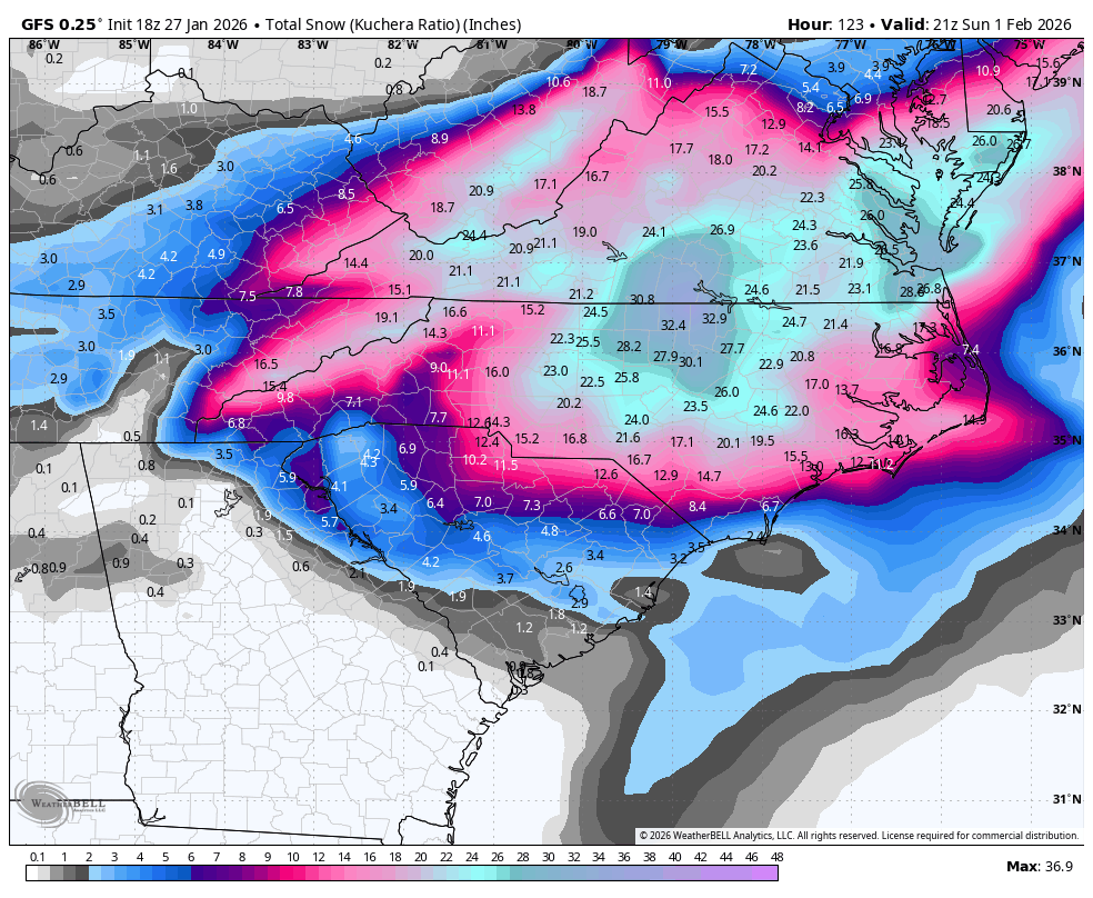
Wintry Machine Learning Mauler 1/30-2/1
- Thread starter SD
- Start date
NBAcentel
Member
Sheesh
View attachment 190165
GEFS continues to push that trough of interest further west as well as strengthening its base.
Another small thing to note is that there's now small (but apparent) ridging between the bulb off of Newfoundland and the one in the Great Lakes. Not sure if it's actively ridging or just due to the separation causing that visual effect.

what's interesting is that while the tail end of the short wave is less elongated, it's also tightening up at the base with lower heights around lake superior. this would help with separation.
It definitely does appear that way from the looks of it. It could be ensemble noise but I'd imagine scenario #1 (base tightening) being the more correct observation here.

It definitely does appear that way from the looks of it. It could be ensemble noise but I'd imagine scenario #1 (base tightening) being the more correct observation here.
Attachments
Brandon10
Member
Anyone have AIGFS snow map?


WAA is doing some nice work throwing moisture on the backside of the strengthening low.

broken025
Member
Every single one of these gives Charlotte some snow. No way we f this up right?

RAH seems to be leaning on the western guidance...
Recent model trends favor a slightly farther west track of the upper
low and surface cyclone, which has increased chances for snow inland
across central NC. With the Arctic air mass already in place, and
forecast soundings showing no warm nose aloft, precipitation would
fall primarily as snow, with no sleet or freezing rain mixing in at
this time. As the upper low moves across the region Saturday into
Sunday northerly flow should help keep the cold air across central
NC through the weekend during the precipitation.
While this Miller-A storm setup is one of the more favorable for
snowfall across the area, significant accumulations are not
guaranteed. Snowfall amounts will depend heavily on the location,
timing, and interaction of the northern and southern stream flow.
Another major factor in play is the location and proximity of the
coastal low offshore.
At this time, confidence is highest for frigid temperatures over the
weekend mixed with a chance of wintry precipitation as early as
Friday night through Sunday morning. However, it is too early to
pinpoint where the heavier snowfall will fall and where the narrow
deformation band would be most likely.


Makeitsnow
Member
This is cool as hell. 25knots of easterly flow colliding with the same from the northwest. Here is 6 hours later and the 850mb flow. One would think that would create some good lift.


broken025
Member
The GEFS snow mean is going to be hilarious
Let me tell you about January 2017Every single one of these gives Charlotte some snow. No way we f this up right?
View attachment 190182
Makeitsnow
Member
If you look at tropical tidbits and scroll through the precip maps you can really get a feel for how the precip would explode and converge right after 84 hours.18z CMC...looks pretty good. Only goes through 84 hours
View attachment 190180View attachment 190181

iGRXY
Member
Can almost guarantee you the mesoscale models will show a significantly more expansive and robust precip shield from this

wow
Member
18z CMC...looks pretty good. Only goes through 84 hours
View attachment 190180View attachment 190181
Pretty darn close to GFS at this timestamp. Vortmax over MO and pinching off over OH valley


Last edited:
The 18z RDPS looked so good that it was moving precip east to west as it was breaking out. Looked like a snow-nado forming. Why they tease like dat?18z CMC...looks pretty good. Only goes through 84 hours
View attachment 190180View attachment 190181

I imagine the radar is going to look absolutely insane in this event as precip basically spawns out of nowhere.
This is still stupid, sorry but that's the post, that is allSupposed to start in exactly 3 days…
John1122
Member
I think we all know that the GFS has some issue that's causing it to perform very poorly this winter. I'd love it to be correct but it's been so bad it's just short of useless.
It showed me getting 12-16 inches from the event last week until 24 hours out. It never stopped showing me getting 8+ until the event was under way. I ended up with 2 inches of snow and .4 ice.
It showed me getting 12-16 inches from the event last week until 24 hours out. It never stopped showing me getting 8+ until the event was under way. I ended up with 2 inches of snow and .4 ice.
Tracking for my areas to the NW/West of ATL...ready to get my hopes destroyed
18z GEFS had about 11 - 20 members with measurable 1 inch snow around West parts of GA all modest/decent hits
12z GEFS had about 8 - 20 members but a few big ones across the SE as a whole
18z GEFS had about 11 - 20 members with measurable 1 inch snow around West parts of GA all modest/decent hits
12z GEFS had about 8 - 20 members but a few big ones across the SE as a whole
UNCSC
Member
I don’t think anyone on here is believing the gfs is going to get even close to hitting those totals, it is just showing that our middle ground of models is still a very strong storm. Gfs will moderate and euro will strengthen most likely. And the in between is still an amazing storm
Totally agree. I think the Euro and AIFS increase some but nothing like the GFSI don’t think anyone on here is believing the gfs is going to get even close to hitting those totals, it is just showing that our middle ground of models is still a very strong storm. Gfs will moderate and euro will strengthen most likely. And the in between is still an amazing storm
wow
Member
I don’t think anyone on here is believing the gfs is going to get even close to hitting those totals, it is just showing that our middle ground of models is still a very strong storm. Gfs will moderate and euro will strengthen most likely. And the in between is still an amazing storm
Well yeah, statistically. But it's still nice to see
")
But it's usually who folds and when? Euro has perked up a bit on the ULL meso-low over W/C NC while the GFS continues to strengthen the cutoff ULL. All while our Google AI God watches us with pity.
Do we believe the GFS? No. But do we feel better it shows this rather than an east/dry solution? YES!
Bigedd09
Member
I think we all know that the GFS has some issue that's causing it to perform very poorly this winter. I'd love it to be correct but it's been so bad it's just short of useless.
It showed me getting 12-16 inches from the event last week until 24 hours out. It never stopped showing me getting 8+ until the event was under way. I ended up with 2 inches of snow and .4 ice.
Well the writing was on the wall for that storm with the track of the storm and warm nose. This storm doesn’t have that
Sent from my iPhone using Tapatalk
Sure would ove to see Google WeatherNext2 start ticking west. I've said it once and I'll say it again. ULL will deliver for those out western Piedmont NC and upstate SC, coastal will get OBX and there's gonna be a minimum in the middle. Probably I-95 corridor, maybe a touch west either way I don't think they both connect and deliver across the whole area. My take anyway.... flame away
Maybe, but GFS has been so bad I'd almost feel better if it was the one showing a whiffDo we believe the GFS? No. But do we feel better it shows this rather than an east/dry solution? YES!
AI GFS Ens does look good
bncho
Member
That's one heck of a snow mean!

Yeah I agree. In terms of how everything comes together, the GFS does make some sense and has some support from ensembles. However we all know obviously that the stupidly insane totals are just not gonna happenI don’t think anyone on here is believing the gfs is going to get even close to hitting those totals, it is just showing that our middle ground of models is still a very strong storm. Gfs will moderate and euro will strengthen most likely. And the in between is still an amazing storm
If this was posted I apologize but wide area of .75 would be major for sureAI GFS Ens does look good

packfan98
Moderator
Yep. Something’s is going to have to give over the next 24 hours one would think.AI GFS Ens does look good

WolfpackHomer91
Member
Let me tell you about January 2017
That one worked out Iredell / Rowan And N/W …. I had a friend in Stanly and remember the Hrrr starting nailing that sharp cutoff basically cutting Meck/Cabarrus in 1/2 he didn’t believe it…. Welp go look at Webbers Site lol
Sent from my iPhone using Tapatalk