Blue_Ridge_Escarpment
Member
Wow. Actually an increase in WNC and extreme Northern SCI hate snow...and everything to do with it. No model can beat Google...its the best
View attachment 190100
Wow. Actually an increase in WNC and extreme Northern SCI hate snow...and everything to do with it. No model can beat Google...its the best
View attachment 190100
Yep, leeside enhancement showing up near the Blue Ridge. January 2003, anyone?Wow. Actually an increase in WNC and extreme Northern SC
Sent from my SM-S156V using Tapatalk
I really wish y'all would stop saying stuff like this with no bases at all other than emotion. Because February as it stands today actually looks greatif this latest threat goes down the toilet its probably over for most of NC to see any snow this winter. This cold pattern is going to break down and even if it gets back to cold in March, that cold isnt January cold.
Bastardi is betting on a further West solution rather than an Eastern one
Yeah it’s prob not so far east that it’s out in the Atlantic. Prob just far enough west that Nantucket gets smokedBastardi is betting on a further West solution rather than an Eastern one
I really wish y'all would stop saying stuff like this with no bases at all other than emotion. Because February as it stands today actually looks great
It sure jumps with its precip maps ( unfortunately east) every run, to be the King. Gonna look bad/ egg in face if those dark greens get back to the coastal plain/ piedmont region over the next few cycles.I hate snow...and everything to do with it. No model can beat Google...its the best
View attachment 190100
Honestly not too late for WeatherNext2 to resolve upper level features a little different and swing back west some. Still 3 days out, but if it's gonna happen it's got to start adjusting with 0z run imo. Also, it could crap the bed this time, it's not 100% accuracy, yet
It was a good run while it lasted, you tried.It's crazy how much things can change from 5 days out to 4 days out with the models.
Yeah it's almost like the atmosphere is fluidIt's crazy how much things can change from 5 days out to 4 days out with the models.
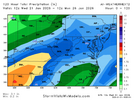
Here is the weathernext taking RDU from nearly 1" QPF ~84 hours out from onset
View attachment 190106
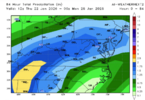
...to just over 0.5" ~60 hours out
View attachment 190107
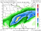
...and then filling back in about 24 hours out
View attachment 190109
I cherry picked a location that was on the fringe of greater QPF because, well, that's where most of NC stands with this coastal. Not here to say "its trending back" or "its trending away" (which it is at the moment, and that can't be ignored). I am just here to say the thing is good but not indestructible and small QPF changes can go a long way for a lot of people.
GSP goes from 1.25 to 1 to just under 1. These are small changes, yes, but again, anticipating high ratio snow means small QPF changes have a greater impact. Let's just see where it goes.
LOL. 12Z Euro has a threat in 8.5 daysif this latest threat goes down the toilet its probably over for most of NC to see any snow this winter. This cold pattern is going to break down and even if it gets back to cold in March, that cold isnt January cold.
well no but that's not the point, i am just saying it is possible for it to make changes that give pretty different results at this range. i understand it isn't the same situation. not denying the trend.Is that just pattern-honing
Impressive that it picked up on that dry slot and amplitude at all. It would have detrimentally impacted the CRPS marginal scoring to go exactly dry out at that range of probabilities within the noise. What I'm not seeing are areas that were predicted dry at T-84 that subsequently increased significantly. That's what we're dealing with now.
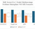
I have faith, the GFS lives!The GFS is gonna beat Google AI. All my years of bashing it, putting it down. It's getting ready to deliver the Holy Grail of all Central NC snowstorms, that will be talked about for Generations.
Seriously though, I googled GFS Verification score. Look at what ole AI had to say about the GFS. "OUTPERFORM ECMWF". Like who wrote this?
AI Overview
View attachment 190119
The Global Forecast System (GFS) model provides high-accuracy, 0.25-degree resolution weather forecasts 4 times daily, with 95-96% accuracy up to 12 hours, 85-95% for 3 days, and 65-80% for up to 10 days. Recent upgrades (FV3 core) have significantly improved its performance, allowing it to frequently outperform the European (ECMWF) model in specific, short-term extreme weather scenarios and tropical cyclone tracking.
If we see another eastward jog like this with the coastal low in the next WeatherNext2 run then the odds of this occurring are very slim. It will make small adjustments that amount to fine tuning the general pattern it has hooked on to but not enough to bring the coastal low back unless something very unexpected happens.Honestly not too late for WeatherNext2 to resolve upper level features a little different and swing back west some. Still 3 days out, but if it's gonna happen it's got to start adjusting with 0z run imo. Also, it could crap the bed this time, it's not 100% accuracy, yet
I don’t trust the gfs worth damn after last weekend. For me It showed 10 plus inch snows and almost no ZR run after run after run until the morning before. And by go time it folded like a cheap suit to the euro with a few inches of snow and a ragging ice storm. I never truly believed it but for obvious reasons was praying it was right for once. I don’t normally bash a model showing a big snow for people, but just letting you guys know how poorly it preformed just days ago.Right now it's GFS and Canadian with a monster storm, WeatherNext, UK and ICON are huge misses, and Euro and Euro AI are somewhere in the middle.
