• Hello, please take a minute to check out our awesome content, contributed by the wonderful members of our community. We hope you'll add your own thoughts and opinions by making a free account!

Wintry Machine Learning Mauler 1/30-2/1

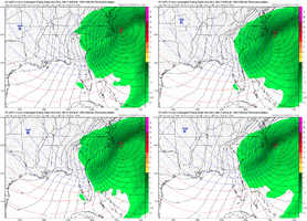
Just my two cents, but it looks like any coastal enhancement will be too late except for maybe moyock/outerbanks.

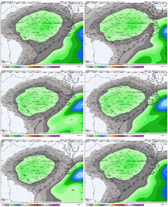
But we’re also coalescing on a nice upper level low snow with a max/jackpot centered around charlotte; with maybe as much as 1/2 inch of liquid there. And decent snows for everyone else in nc/sc too. And even northeast Georgia.

I’ll be shocked if we wind up with something at go time thats much different than that.
This is my thought as well. Unless we just hit the fan and flatten this thing all the way out, I feel good right now about the ULL and it over performing. The coastal is much more in question IMO
 
I’ve said it a couple of times but historically 2 things have been true. ULL’s out of the N/S tend to dig further west and amplify, usually to our detriment imby as we end up with rain or ice vs snow, and the 50/50 trends further NE as we get closer. Both of those things have historically not been good for us, but would be in this instance. Let’s see if history sticks to its guns or we screw it all to hell.
 
Well, here's something quite similar to Dec 2010. If I recall correctly, that storm got lost and I mean completely lost for a day or two. Came back suddenly towards last minute go time. So much energy to resolve. Ukmet definitely took a huge step in the wrong direction. The GFS went nuclear. CMC moderated itself a bit.
Your recollection is absolutely correct. It vanished for 4 runs, long enough for everyone to go into mourning over the lost opportunity. Then 48 hours out, it popped up again.
 
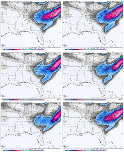
I know this will change, but this is starting to look like the Jan 24-25 Carolina crusher, just 50-75 miles farther north and west. Hopefully that GSP to Anderson and Pickens minimum goes away before too long.
Thats a valid concern because we've lived it. Just west and east of that you get smoked. Nam and rgem will be the one to watch to see where that sets up imo
Nam scores well for ULL and gfs does pretty well with them also. The euro not so much.
 
We've seen these dig back further west all winter it seems...and GEFS is trying to keep that up

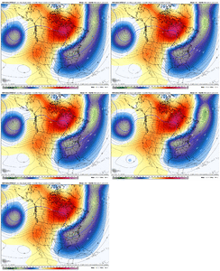
View attachment 190049
Something the GFS ensembles are doing right now is keeping the right balance of the western ridge/+AO blocking to allow the northern stream press. One of the strengths that the GFS does have is handling northern stream systems a little better than some other modeling(and also the biases that it presses too strongly sometimes).

Obviously, we're within 3 to 4 days, and having subtle energy differences outside of that are having huge implications downstream on effects at this juncture.
 
If we weren't losing random huge systems in the ensembles I would feel like the ops were just oscillating around the guidance envelope. Losing the thumb ridge over the top of the system in Canada seems like it might be what the euro suite is picking up on and this causes the flow to get too north to south flattening the wave some and accelerating it. Interested to see what the op euro does the icon and gfs are doing what you would expect right now with slow incremental NW moves
 
Something the GFS ensembles are doing right now is keeping the right balance of the western ridge/+AO blocking to allow the northern stream press. One of the strengths that the GFS does have is handling northern stream systems a little better than some other modeling(and also the biases that it presses too strongly sometimes).

Obviously, we're within 3 to 4 days, and having subtle energy differences outside of that are having huge implications downstream on effects at this juncture.
Chaos theory in full effect.
 
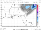
Not calling it a womp but the AIFS is a bit drier in general but still has the 0.4"0.6" QPF max in CNC

View attachment 190053
That’s basically exactly what consensus is right now. It’s not bad either. People just need to get their expectations checked.

The only question is whether or not we can hold that look. several models on either side of this depiction right now, but a euro ai/weathernext consensus at day 4 is gonna be tough to beat.
 
We've seen these dig back further west all winter it seems...and GEFS is trying to keep that up

View attachment 190049
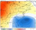
You keep backing that energy of Baja back west, it causes pac ridge to nudge west and gives TPV backside room to dig back toward MO/KS more.
You look at that Baja gyro on ukmet an euro, compared to GFS and Canadian, you can see. Closer it is to mexico/ usa, the more resistence pac ridge is gonna stop our digging back sw of the TPV
 
That’s basically exactly what consensus is right now. It’s not bad either. People just need to get their expectations checked.

The only question is whether or not we can hold that look. several models on either side of this depiction right now, but a euro ai/weathernext consensus at day 4 is gonna be tough to beat.
don't forget UK as well
 
Obviously shifting east though. Not what any of us wanted to see I don't think. Whiff is more and more likely IMO.
The ULL itself is barely east of where it's been which is just noise. If you're relying on the ULL itself for snow you're fine right now. It's places east that don't need to see the ULL move east. Western areas would like it to stay west so we can get greedy vs not getting snow.
 
The whole thing looks like it's trending to tilt sooner though given the trends up north so I'd have to wonder if the southern end is just noise trying to figure out how that'll interact. I don't think we are done changing solutions and almost bet it will go W more but just not yet
 
To me this is just loss of the coastal influence and cold core aloft/TPV donut becoming the driver, the amounts hasn’t went down much in far western areas (upstate for example) in fact they have remained the same. This is the way weathernext delivers as well. Lower ceiling, but a still pretty solid event IMG_3508.gif
 
To my untrained eye, that looks more like minor fluctuations rather than a trend no?
Yeah the features are pretty much the same. The output is slightly different. It's static. But it would be good to see things close off farther SW and turn neutral/negative quicker.
 
Back
Top