NWS Columbia
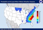
Physics based and AI guidance has trended towards a favorable setup
for potential snowfall this weekend. Its done this fairly quickly
over the last 4-6 model runs, showing a northern stream
shortwave
diving out of the Hudson Bay & phasing with a southern stream
shortwave & rapidly amplifying over the TN Valley to our west. The
Canadian &
ECMWF suite of guidance (both physics-based and AI) were
the first to trend in this direction & this has continued overnight.
The
GFS has trended towards this with the 00z run tonight,
increasing the confidence in the possibility of snowfall this weekend
across the forecast area. The forecast is slightly simpler than it
was last weekend as
thermal profiles look like they`ll favor snow as
the predominant p-type, though this could always change as we get
closer to the event itself. The airmass associated with this is
forecast to be straight up gelid, so overall snow would be favored.
While confidence is increasing overall, this is a complex setup that
will (as always) require several things to fall into place just
right in order for us to see snowfall across the area. A slight
difference in the placement of each individual part would yield a
significant difference in our expected outcomes. AIFS and AIGFS
guidance is very similar to one another on the 00z, with the AIFS
showing a very consistent
synoptic scale pattern run-to-run over the
past 24h. I`
d probably favor this guidance right now as it has been
verifying well lately when compared to the physics-based guidance.
It`ll be interesting to see how this event pans out. It is uncommon
to have a signal for widespread precip like this that also overlaps
with an atmospheric profile cold enough to support all snow. Stay
tuned!