rusrius
Member
Good night all and stay warm and safe.
I saw that. He was using the Barron 3K model. That is his house model.View attachment 188805
I turned it on after you said that and when they just showed it again, it doesn't show temps at freezing
This might end up being the highlight of this entire event. I’m genuinely curious to see if this line of thunderstorms can erode the CAD enough to make it through here. I have seen thunderstorms happen here in the 30s, but not so close to the freezing mark.View attachment 188805
I turned it on after you said that and when they just showed it again, it doesn't show temps at freezing
I can confirm. It's snowing here as well.


Just wanted to say….. this ain’t sleet. Not a pinger has been heard in about 20 min. I just be on some transition line but this is 100% snow for last 20 min. Sleet doesn’t float like this pixie dust is, and you can brush it and it’s dry and fluffy on top not like sleet…… Dusting Mooresville NC 11PM EST …..Hwy152/Linwood Rd
Sent from my iPhone using Tapatalk
Ten minutes later it shows ATL at 33 and everything NE of it below freezing.View attachment 188805
I turned it on after you said that and when they just showed it again, it doesn't show temps at freezing
Keep doing you as you. You're awesome.I love you brother. But, isn’t there an “Outside the SE Thread”? I love your posts and myself don’t mind at all. However, A life safety event is occurring across the SE. Look … I’m of the opinion “If you don’t like it just scroll past” OH.. I also understand the upstream updates. Appreciate the updates Brent.
While that model might be one of the cold outliers, I would not be entirely shocked if the CAD is stubborn to erode in this region, specifically around the north side. There have been so many times that a severe weather outbreak which was forecast to move well into northern GA was blocked by the CAD/rainfall preventing warmer temps which often caused a deficit of 5-10 degrees. In this case where the forecasted high is upper 30s to 40 degrees, 5-10 degrees lower is easily flirting with freezing rain.I saw that. He was using the Barron 3K model. That is his house model.
Yes, it is snowing all over the western piedmont.It’s either really light freezing mist or light snow here in Concord. A little sleet mixed in for sure but I swear it looks like tiny snow flakes not mist? Anyone nearby seeing the same?
What in the world? This storm has wore me out!Yes, it is snowing all over the western piedmont.


I’m a bit confused. Has it been dry in the upstate? Or has it been slow moving in here? Are we still expecting a good bit tonight and tomorrow? Sorry just expected more in the upstate before now
I just saw what you were talking about and then he shows .13 ice for Atlanta with that model, so something doesn't add upI saw that. He was using the Barron 3K model. That is his house model.
TWC used to be on in my house for days leading up to a winter event. I haven't watched them in years. Now I just hang out here with multiple tabs of radar, models, obs, etc.I just checked TWC live broadcast. What a joke. I mean, a historic winter event is affecting half of the US. They are airing some kind of reality show. Not the go to channel most of us grew up with. That sucks !! Oh well
I just saw what you were talking about and then he shows .13 ice for Atlanta with that model, so something doesn't add up

Like a pressure washer when you shoot it up in the air and all those droplets just whizzing around. Im With you. Never seen this before.Legitimately one of the more beautiful snows I’ve ever seen fall - it’s all so sparkly.
15.8/13.3
As they should at this point, the writing is on the wall. We’re already at freezing (at least wet bulb temps). We’re not warming up overnight, and we’re in the bullseye for that moisture coming straight from southern Alabama. It’s here.
The way that precip is filling back in towards Birmingham. They might be right.
As they should at this point, the writing is on the wall. We’re already at freezing (at least wet bulb temps). We’re not warming up overnight, and we’re in the bullseye for that moisture coming straight from southern Alabama. It’s here.
I thought the point of their post was that FFC didn't raise our totals.As they should at this point, the writing is on the wall. We’re already at freezing (at least wet bulb temps). We’re not warming up overnight, and we’re in the bullseye for that moisture coming straight from southern Alabama. It’s here.
Other resources and models were cutting back on precip. FFC is saying that the models are wrong and are continuing with what they forcasted.I thought the point of their post was that FFC didn't raise our totals.
I'll take about what was expected at this point
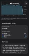
Ignore the audio i had ANF and FOX5 in the background. Radar image is from weatherwise
I think this may have been another case of the NBM (average of all models) is shown by the NWS and it is not a human forecast.Other resources and models were cutting back on precip. FFC is saying that the models are wrong and are continuing with what they forcasted.