Just started sleeting here about 15 minutes. Light right now, but perhaps the atmosphere is starting to moisten up a bit
-
Hello, please take a minute to check out our awesome content, contributed by the wonderful members of our community. We hope you'll add your own thoughts and opinions by making a free account!
You are using an out of date browser. It may not display this or other websites correctly.
You should upgrade or use an alternative browser.
You should upgrade or use an alternative browser.
Wintry January 23rd-27th 2026
- Thread starter SD
- Start date
beanskip
Member
This is going to sound loony, but there is just such a randomness to it -- no discernable trends to grab a hold of -- models inconsistent with each other and run to run themselves. Wild swings that are difficult to explain. Very strange.I can’t ever remember there being such a crazy QPF fight
FV3 follows 3k nam and speeds up the last line, almost over clt by 5p now and through upstate sc
Brent
Member
Stormsfury
Member
Mpirone12
Member
Is that what was being discussed earlier? Where storms in the gulf would enhance moisture upstream ?
Sent from my iPhone using Tapatalk
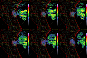
It's a futurecast radar for next weekend.Sure, let's spin up a low east of JAX.
View attachment 188749
Who had that on their bingo card?Sure, let's spin up a low east of JAX.
View attachment 188749
Brent
Member
Is that what was being discussed earlier? Where storms in the gulf would enhance moisture upstream ?
Sent from my iPhone using Tapatalk
Possibly yeah
The thing that has hurt us so far is we had moisture cutoff from the south down in Texas
ChattaVOL
Member
This isn’t going to make anyone in Georgia or The Carolina’s feel great.
I was suppose to be an above freezing by 4 pm and I’m still under freezing as of right now.
Sent from my iPhone using Tapatalk
I was suppose to be an above freezing by 4 pm and I’m still under freezing as of right now.
Sent from my iPhone using Tapatalk
Mpirone12
Member
Possibly yeah
The thing that has hurt us so far is we had moisture cutoff from the south down in Texas
This storms a tough one. I don’t know if we will know the outcome until it’s over. So many variables. It’ll be a great storm but final product is TBD
Sent from my iPhone using Tapatalk
GeorgiaGirl
Member
Sure, let's spin up a low east of JAX.
View attachment 188749
Can't say I'd be too bothered if it did, but I wonder if this would literally cause the moisture robbery shown on the HRRR?
What it shows near the coast is interesting, but there literally is a 50 mile swath around I-20 that is completely blank overall.
ChattaVOL
Member
If I was 1/2 degrees cooler. I would be cooked. Light precip is coating everything here at 31
Sent from my iPhone using Tapatalk
Sent from my iPhone using Tapatalk
Snowflowxxl
Member
Did they lower it?
Nerman
Member
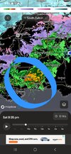
That is going to track up 85View attachment 188750
I think this is hiting the totals and robbing that energy!
We will see.. the rain is so spotty here in ATLThat is going to track up 85
WTHSure, let's spin up a low east of JAX.
View attachment 188749
CNCsnwfan1210
Member

Nice looking WV loop with a trough over west TX , pulling up moisture out of the Pacific/Gulf, great example of warm air advection overriding an arctic airmass.
Sent from my iPhone using Tapatalk
This is really bad, there’s already a glaze in Raleigh
The road is slick and there must be more freezing rain mixed in than I realized.
Last edited:
WxBlue
Meteorologist
I
I was looking at that until I saw the direction they were moving. SW to NE… once they ride up over the CAD it’ll probably give precip extra enhancement. If these storms were moving W to E it would be differentView attachment 188750
I think this is hiting the totals and robbing that energy!
I thought about that tooI
I was looking at that until I saw the direction they were moving. SW to NE… once they ride up over the CAD it’ll probably give precip extra enhancement. If these storms were moving W to E it would be different
Thanks for posting this! I knew something was going on but got no answer on the other forum site…. My amateur eyes aren’t just seeing things…. This will throw moisture back into the SE right?Sure, let's spin up a low east of JAX.
View attachment 188749
Brent
Member
Ron Burgundy
Member
Yep. If that holds together it is gonna be lights out in NGAI
I was looking at that until I saw the direction they were moving. SW to NE… once they ride up over the CAD it’ll probably give precip extra enhancement. If these storms were moving W to E it would be different
Downeastnc
Member
Sure, let's spin up a low east of JAX.
View attachment 188749
I saw this as well, being in eastern NC I always look for something in the ATL to maybe enhance or help the pecip. Not sure this will but its always fun to hope somehow the models missed something.
Darklordsuperstorm
Member
rburrel2
Member
That moist uplgide becoming evident on gsp radar. And I’ve got a fine mist falling now too. Should keep at least light precip going all night I think once we finish saturating.
So with the Triangle area already seeing ZR, are we just cooked and staring down the barrel of a major ice storm with minimal sleet? Or will heavier rates help us there? I'm not sure. We are still seeing sleet, but it's mixed with ZR more than I realized after taking a walk out there. The cars, etc. are already glazed over.
Well, we knew this was coming. The sleet mix should help a bit for now but soon it will switch over completelySo with the Triangle area already seeing ZR, are we just cooked and staring down the barrel of a major ice storm with minimal sleet? Or will heavier rates help us there? I'm not sure. We are still seeing sleet, but it's mixed with ZR more than I realized after taking a walk out there. The cars, etc. are already glazed over.
Stormsfury
Member
It's apparently enhancing some light precip later tonight across the Eastern part of the Tri- ▪County area of the Lowcountry. Unfortunate that the KCHS radar site has a failure and the needed parts won't be in until Monday.I saw this as well, being in eastern NC I always look for something in the ATL to maybe enhance or help the pecip. Not sure this will but its always fun to hope somehow the models missed something.
Heelyes
Member
We might be in troubleSo with the Triangle area already seeing ZR, are we just cooked and staring down the barrel of a major ice storm with minimal sleet? Or will heavier rates help us there? I'm not sure. We are still seeing sleet, but it's mixed with ZR more than I realized after taking a walk out there. The cars, etc. are already glazed over.
Yeah, I was hoping we would get at least 1" of sleet before the changeover, but perhaps not, although maybe we can mix our way to that.Well, we knew this was coming. The sleet mix should help a bit for now but soon it will switch over completely
Brent
Member
This is definitely the peak here so far
iwantsouthernsnow123
Member
SFC low has been expected the entire time, for at least the past few days models were showing energy off the first shortwave then tracking NE and eventually making its way right off the NE coast.Sure, let's spin up a low east of JAX.
View attachment 188749
iGRXY
Member
Can’t wait. In Clayton with freezing drizzle

