It's gotta be close. At the very least, its impressive the sheer scale. Warnings from the TX/Mexico border to Maine/Canada for one.Could this be a record for most active winter weather products at one time?
-
Hello, please take a minute to check out our awesome content, contributed by the wonderful members of our community. We hope you'll add your own thoughts and opinions by making a free account!
You are using an out of date browser. It may not display this or other websites correctly.
You should upgrade or use an alternative browser.
You should upgrade or use an alternative browser.
Wintry January 23rd-27th 2026
- Thread starter SD
- Start date
WolfpackHomer91
Member
I’m out driving around …. Sleet in the 801 - Troutman area
Sent from my iPhone using Tapatalk
Sent from my iPhone using Tapatalk
I know that I am rooting for two things to happen that some of the models are showing for Central North Carolina:
1. The dry slot showing up and cutting total QPF on Sunday
2. The warm air flowing in from the coast overcoming the CAD and turning this into rain for the Triangle from Sunday afternoon forward.
If either or both of these happen, ice accrual will end up in the RDU area at around .25 inches or less. If not, the totals go up close to .50 inches and potentially higher depending on QPF rates. I am not a professional meteorologist so this is based on my gut feelings based on the data I've seen.
rburrel2
Member
rburrel2
Member
We’re trending colder at 925mb too. Sleet bomb incoming for the upstate
HRRR is not a good look for the city(ATL).......if it holds true.
For those on the south side of some of these silly CAM forecast low QPF totals, may I suggest taking a gander at regional radar?

 weather.cod.edu

COD NEXLAB: Satellite and Radar
Check out COD Meteorology's Satellite and Radar Data
WxBlue
Meteorologist
2nd UNC Asheville balloon just launched. Warm nose has increased from 2°C to 3.8°C in last 3 hours. It is above freezing from 1540 m to 2926 m.
Snowflowxxl
Member
Mpirone12
Member
Does anyone have HRR total precip?
Sent from my iPhone using Tapatalk
Sent from my iPhone using Tapatalk
dsaur
Member
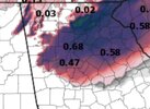
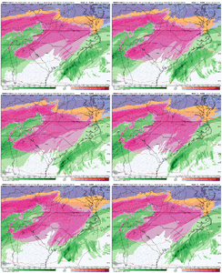
It strikes me that it's about interpretation. Each storm teaches us about reading the tea leaves. There is an art to weather that machines can't compete with. If the masses really cared about the weather they'd insist on data out the wazzoo and banks of supercomputers to crunch 10, 20, 50 times the data available now. It's doable but cost money, so the public gets the foolproof prediction they pay for. I still don't know for sure how much zr I'm getting, because it feels like more than a quarter inch standing out there in the still expectancy, and I know what cads do down here...and that there is the art in it.The event is on our doorstep and we've got differences like this showing up between the modeling. The ICON has literally double or more the precip of the GFS in several locales, pretty insane considering the event has already begun. Makes you just figure all we can do is watch radar and see.
View attachment 188639View attachment 188640
iwantsouthernsnow123
Member
Absurd to me how there is a risk of another winter storm potentially before some areas even completely recover from this weeks.
That warm nose means business.2nd UNC Asheville balloon just launched. Warm nose has increased from 2°C to 3.8°C in last 3 hours. It is above freezing from 1540 m to 2926 m.
This is what some of us have asked for.Absurd to me how there is a risk of another winter storm potentially before some areas even completely recover from this weeks.
beanskip
Member
SnowDeac
Member
I still don’t see how this low is possibly going to ride the apps and transfer from Roanoke to the Jersey Shore (as the NAM shows). That wedge is stout!
Also, perhaps a dumb question but is there any chance those bands in the Atlantic off N FL/S GA pop a secondary low and merge with our main storm?
Also, perhaps a dumb question but is there any chance those bands in the Atlantic off N FL/S GA pop a secondary low and merge with our main storm?
wow
Member
I'm off 801 by Mt Ulla elementary.. haven't seen much of anything so far.I’m out driving around …. Sleet in the 801 - Troutman area
Sent from my iPhone using Tapatalk
dsaur
Member
Hunker down. I think it's been underplayed too much. In that wind it's gonna get bad.HRRR is not a good look for the city(ATL).......if it holds true.
LukeBarrette
im north of 90% of people on here so yeah
Meteorology Student
Member
2024 Supporter
2017-2023 Supporter
HRRR has been right in terms of the front end thump for VA folks. NAM too warm and did not have much snow up to this point for us. Got about a half inch with 5-6 more hours of snow to come. Just wish it was heavier, our flakes are tinyyyyy
Corey Ford
Member
We’re trending colder at 925mb too. Sleet bomb incoming for the upstate
Do we have a sense of how long the 925 will support sleet for the Upstate and CLT areas?
NewnanWetather
Member
For Newnan area?Hunker down. I think it's been underplayed too much. In that wind it's gonna get bad.
WolfpackHomer91
Member
Hunker down. I think it's been underplayed too much. In that wind it's gonna get bad.
I can promise I just got home….. no one 250 miles North of you takes it seriously apparently. Tons of people out just eating dinner doing normal Saturday things
Sent from my iPhone using Tapatalk
Mpirone12
Member
Just started in the triad
Sent from my iPhone using Tapatalk
Sent from my iPhone using Tapatalk
I believe it could be bad but also why shouldn’t I enjoy a normal Saturday? We’re still hours away from the onset.I can promise I just got home….. no one 250 miles North of you takes it seriously apparently. Tons of people out just eating dinner doing normal Saturday things
Sent from my iPhone using Tapatalk
packfan98
Moderator
Flurries here.
Westganick
Member
It’s not coming in until after midnight. People can go out in the evening and enjoy a dinner to support resteraunts that may be closed tomorrow. It is a normal Saturday night for normal folks.I can promise I just got home….. no one 250 miles North of you takes it seriously apparently. Tons of people out just eating dinner doing normal Saturday things
Sent from my iPhone using Tapatalk
beanskip
Member
If the HRRR doesn't watch out it's going to take the CAD into Alabama! 23z run extends it further, just one county away from the border.
beanskip
Member
On the other hand, the QPF keeps drying up along I-85 -- at lesat early in the run. Presumably those two things are connected.If the HRRR doesn't watch out it's going to take the CAD into Alabama! 23z run extends it further, just one county away from the border.
Brent
Member
a_gilmore88
Member
Already have a mix of sleet and freezing rain in SE Rowan County, 21.9°. Not good at all for future ice totals.
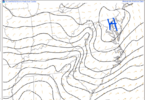
I don't mind seeing CAE being drierCheck out areas closer to the coast with this trend. View attachment 188707
Real nervous about hwy 49 corridor from uncc up to Asheboro Burlington, uwharrie region. If we get 1.0 plus qpf up through there, gonna be disaster by sun post those winds off squal line. Kannapolis frzng rain already is a bad omenI'm off 801 by Mt Ulla elementary.. haven't seen much of anything so far.
Almost looks like the new low is trying to form off the SC coast instead of the NC/VA coastCheck out areas closer to the coast with this trend. View attachment 188707
Well, I don’t think that’s the trend here. That dry air no doubt will be freezing rain IMO. The trend is to a more moist scenario to our East.I don't mind seeing CAE being drier
iGRXY
Member
Would support the idea of the initial surface low not going nearly as far north before it transfersAlmost looks like the new low is trying to form off the SC coast instead of the NC/VA coast

