NCWeatherNow
Member
Depends on what part of NCSeems like some are calling for a “bust” in the Carolina’s with QPF steadily decreasing. Folks here agree?
Depends on what part of NCSeems like some are calling for a “bust” in the Carolina’s with QPF steadily decreasing. Folks here agree?
Ha, yeah I remember making a post about the Canadian opening the escape hatch across the Great Lakes.....and boy did it openGot a fun thing to throw into
Was looking at op model trends from when we first latched onto this event
The Canadian killed it. Called northward tilt much earlier than anyone else. This is when we were all (me) clowning it for unserious. Post for another day
Would be awesome around here tbhNot sure there's really much reason to look at it at this point, but the 12z GFS was possibly the driest I've seen of it yet for the Carolinas. RDU was in the 0.7-0.8" range and GSO was even short of 1". Meh.
I think it's going to come down to how far south the banding sets up and that's going to be very hard to predict. A normal model error will easily have huge impacts. Either way, a Warning criteria major event is happening; the question is more on whether it will be something we remember for many years here or if it's just another ice storm. Things seem a little more locked in for the former in upstate SC, etc.
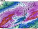

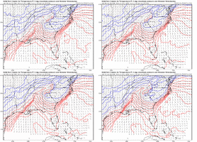
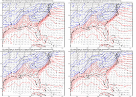
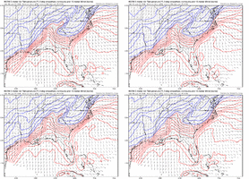
Noticed that, too; it's the opposite of what I would've expected leading directly up to the event. Maybe they'll be wrong or maybe my line of thinking is outdated?The mesoscale models all seem to be trending the CAD to be less potent. Here are the trend loops for NAM, FV3, and RGEM. For each model , I selected the forecast hour that showed the farthest extent of CAD and then did the trend for most recent 4 model runs. Maybe none of them have a handle on CAD potency/persistence but a trend is a trend.
View attachment 188535
View attachment 188534
View attachment 188536
Would be awesome around here tbh
View attachment 188538
Question is, does that become a moisture transport or moisture robber?Regional radar and satellite have prolific moisture along the Texas coast and SW Louisiana heading ENE.

COD NEXLAB: Satellite and Radar
Check out COD Meteorology's Satellite and Radar Dataweather.cod.edu
Interesting. I've also noticed the 40s starting to work their way back into upstate South Carolina. It could be legit.The mesoscale models all seem to be trending the CAD to be less potent. Here are the trend loops for NAM, FV3, and RGEM. For each model , I selected the forecast hour that showed the farthest extent of CAD and then did the trend for most recent 4 model runs. Maybe none of them have a handle on CAD potency/persistence but a trend is a trend.
View attachment 188535
View attachment 188534
View attachment 188536
In comparison, the 12z ICON is about as wet as ever. Kind of interesting how the banding sets up such that the Triangle out-QPFs the Triad! We'll see! Definitely don't favor using the globals too much with this system, anyways; just posting this for map porn, LOL!Not sure there's really much reason to look at it at this point, but the 12z GFS was possibly the driest I've seen of it yet for the Carolinas. RDU was in the 0.7-0.8" range and GSO was even short of 1". Meh.
I think it's going to come down to how far south the banding sets up and that's going to be very hard to predict. A normal model error will easily have huge impacts. Either way, a Warning criteria major event is happening; the question is more on whether it will be something we remember for many years here or if it's just another ice storm. Things seem a little more locked in for the former in upstate SC, etc.
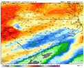
In comparison, the 12z ICON is about as wet as ever. Kind of interesting how the banding sets up such that the Triangle out-QPFs the Triad! We'll see! Definitely don't favor using the globals too much with this system, anyways; just posting this for map porn, LOL!
View attachment 188540
The RGEM, which I believe does pretty well with CAD setups historically, looks more similar to the ICON.
The thing is that the ICON, which is crazy cold, has ATL at 46/22 at 1pm. Observed at noon, is actually 45/19Interesting. I've also noticed the 40s starting to work their way back into upstate South Carolina. It could be legit.
I don't think so at all. Quite the opposite, actually. Tells me substantial precipitation will make its way into N. Ga early this evening.Question is, does that become a moisture transport or moisture robber?
What are they showing?With model trends on qpf I think we can take the biblical solutions off the table for the upstate. No 2-3 inch liquid totals showing up on the hi-res models. Still going to be bad though
YesExtremely novice/dumb question but what will this precipitation “look” like once it starts in NE GA? Will it look/sound like a rain storm outside?
Freezing RaIn will sound like rain as it is a liquid until it makes contact with sub freezing surface... You can/will hear IP (sleet) as it strikes hard surfaces and "pings" etcExtremely novice/dumb question but what will this precipitation “look” like once it starts in NE GA? Will it look/sound like a rain storm outside?
Probably, though we'll see. Given how unusual wintry systems are that bring that much liquid equivalent, I always had a little doubt in my mind about the totals we were seeing. That being said, this is a juicy system and some modeling is still showing pretty high totals; it is not inconceivable that we could bust on the high side and see those biblical totals, even if I wouldn't necessarily favor it.With model trends on qpf I think we can take the biblical solutions off the table for the upstate. No 2-3 inch liquid totals showing up on the hi-res models. Still going to be bad though
Probably, though we'll see. Given how unusual wintry systems are that bring that much liquid equivalent, I always had a little doubt in my mind about the totals we were seeing. That being said, this is a juicy system and some modeling is still showing pretty high totals; it is not inconceivable that we could bust on the high side and see those biblical totals, even if I wouldn't necessarily favor it.
Sleet / ice pellets are little pellets of ice. It'll be loud and they can sometimes even sting a little depending on how heavy it is falling. Freezing rain will seem like a normal rain event except things will start to be coated in ice after a while and then trees, etc. will start falling. Depending on soil / ground temps, freezing rain is sometimes mostly confined to elevated surfaces, sometimes just to trees and grass blades, etc., or in the worst cases it can freeze on the road (which will probably happen for many here given the surface temps). Moreover, many will probably start as sleet first and that will cover the roads before the ZR starts, and so the ZR will just freeze on top of the sleet that's already sticking.Extremely novice/dumb question but what will this precipitation “look” like once it starts in NE GA? Will it look/sound like a rain storm outside?
Wondering that, too. Just realized I was looking at the 06z run and not the 12z run earlier.Did the 12z rgem never come out?
Who is focusing on it? Just sharing model output, which for central NC is not a stretch considering dry slot. These comments are what irritate posters. Oh and look NAM very similarGuys I’d stop focusing on the GFS and start looking at the short range models. HRRR and NAM
Sent from my iPhone using Tapatalk
