accu35
Member
Euro may do it

It’s right where we want it for nowSomeone plz post the euro when it’s done. I have stayed up to see if it shows next weekends storm
A healthy clip was there though and you post the EURO AI. Thank youSuppressed but that’s good as of now

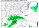
Yeah, this look here is big time potential once it starts trending NW a little.Very nice
View attachment 188368
Yep in my opinion the fact that it gets smashed into the gulf after this frame is moneyYeah, this look here is big time potential once it starts trending NW a little.
Nah let the Euro cook we've got a long time on this oneAnd the Euro is how we lose.


Storm signal still there.The 6z AI Euro is just depressing, don't look.


That's one of the funniest NWS forecast discussions I've read.KATL discussion about next weekend..
This is the part of the AFD where I get to do my favorite PSA -
friends don`t let friends share single model runs of 10:1 snow
totals 8 to 9 days out on social media. From any model. Yes, I am
judging you for posting that GFS run. Anyway, while the
operational version of the GFS keeps posting varying fun totals,
the GEFS puts the probability of an inch across areas around
15-20%. The probability of 4" is basically 4%...a single member,
most likely. So, let`s just pump the brakes on talking about the
next storm, and wait for a bit more model consistency (the Euro
ensemble, for instance, locates probabilities a bit further north
than the American). We`ve got bigger fish to fry this weekend.
&&
Sent from my iPhone using Tapatalk
Euro at least has the one run trend of what we need to see more of with the closed low / TPV over the Lakes and NE


View attachment 188452View attachment 188453
Starting to gather more eps support and some big ones at that. Hope it keeps growing!


Way too much dig. It's still extremely positively tiltedView attachment 188500
Icon is seconds away from something big


Way too much dig. It's still extremely positively tilted
View attachment 188506
Bingo! Not that far off here. Plenty of time to work this one. Hope to see some positive moment soon in our direction here for Central Alabama.Need the two pieces of energy phased instead of one piece diving to oblivion.
View attachment 188503


To suppressed in bama. Would be nice for the nw shift and increase moisture for a good state wide sweep.