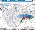
I guess it comes down to which model has a better handle on the CAD. Here's the GFS. Small differences change lives.
Hope you guys do well in Atlanta.

I guess it comes down to which model has a better handle on the CAD. Here's the GFS. Small differences change lives.

The warmest run and still my area near an inch of ice. I’m very thankful I work for a company where generators are easily accessible. NE ga and upstate sc should be ready for power outages. Thankfully this storm gave us enough heads up
I'm not buying the Sleet / ZR maps on the Euro. Something is really off. I think that a lot of that ZR is really IP.The Euro is scary for ice accumulation in the Piedmont-Triad. You would think it would be more sleet, but that map is worrisome. Even 1/3 of those totals would be lights out for a wide area


Note these precip type maps for the Euro are unreliable. There would be a lot more sleet than that IMO. They almost never show enough and show it as almost all ZR.Very little sleet on 00z Euro
View attachment 187365

To be honest, I wouldn't be surprised if the mid level and upper level sounding are off for even GA and it would be more sleet than ZR as we get closer.Note these precip type maps for the Euro are unreliable. There would be a lot more sleet than that IMO. They almost never show enough and show it as almost all ZR.

Flo, let's be honest and fair, these models don't have a good handle on this system at all. One will win and in my case I hope it is the Euro.Euro has to be off. No other explanation

nightmare fuel for our areasVery little sleet on 00z Euro
View attachment 187365
GFS was colder at the surface by a margin. All of the Piedmont was in the teens. Your conclusion is sound.Looks like it stays in low-mid 20s in NC for most of the event
Greensboro warms to 32 briefly towards the end. Raleigh 34 briefly.
Bottom line looks like it's settled on a major ice storm for many in the Carolinas...
View attachment 187371
currently looking like a pile of sleet with a thick layer of freezing rain on top... and im extremely nervous about it00z Euro is 1.75-2" liquid equivalent of basically all-frozen (except maybe the last tiny bit) for the Triangle. Wow.
I don't think I've ever been nervous before any of these storms, but this one might be an exception. No power and temperatures near 0 on Monday / Tuesday at night are a dangerous situation. On the one hand, experiencing a historic storm will be something I'll always remember, on the other hand this is fixing up to be a complete disaster.currently looking like a pile of sleet with a thick layer of freezing rain on top... and im extremely nervous about it
I'm wondering if they will have court anywhere in central NC next week. (Attorney comment)I’m genuinely beginning to wonder if the big universities in NC as well as clemson have class at all next week. I can’t imagine anything before Wednesday and that feels a bit optimistic. I’ve never seen values this high anywhere really and it’s just pure ice and with cold temperatures after, this is going to take awhile to melt and infrastructure just isn’t built for a storm of this magnitude

This is the first time I have ever been under a winter storm watch and actually praying for the "upgrade" to the dreaded "downgrade" sounding "winter weather advisory". or just as good, a dropped watch and nothing at all.
ice loving folks. on some level, I get you. the drama. loving winter weather in general. or just extreme weather. but being trapped with no heat for days lasts a lot longer than the fun part. and i love trees. and generally not a fan of others suffering. unless they are obnoxious mid atlantic/NE folks entitled to snow. and even then, I say that only in fun.
NWS in New Orleans issued a Winter Storm Watch for parts of LA and MS including Baton Rouge for a tenth of an inch of ice with up to a quarter inch possible.
The reason I share this is that neither the Euro or GFS show any frozen precipitation down that way. Euro even has Baton Rouge at almost 70 Sunday morning when this watch is in effect. Maybe some of the ensemble members are showing something? Do they think the system could be coming further south?
This probably doesnt even have any impact upstream, but I found it interesting to mention.

NOT SURE WHAT YALL ARE LOOKING AT BUT THE 0Z GFS CLEARLY HAS SOMETHING THERE. OR HELL I MAY BE SEEING SOMETHING TOTALLY DIFFERENTIt is oddly disconnected from other offices. What are they seeing that others aren’t?
View attachment 187384


Yeah. The GFS has sent me into panic mode with its continued showing of apocalyptic ice.NOT SURE WHAT YALL ARE LOOKING AT BUT THE 0Z GFS CLEARLY HAS SOMETHING THERE. OR HELL I MAY BE SEEING SOMETHING TOTALLY DIFFERENTView attachment 187385View attachment 187387View attachment 187386


FUNNY YOU SPEAK OF THAT. ITS KINDA LIKE LOCAL TV METS THAT MAKE THEIR OWN SEVERE WEATHER GRAPHICS AND THEY LOOK TOTALLY DIFFERENT THAN NWS OFFICE PRODUCTS OR THEY HAVE A COMPLETLY DIFFERENT FORECASTYeah. The GFS has sent me into panic mode with its continued showing of apocalyptic ice.
But… I’m not a met. Just an iOS engineer and developer. I trust the pros at FFC. But the pros in other offices. I do wonder why the disconnect. It’s not making me feel better.
But I’m rounding to not panicking. Because I trust the pros at FFC. In bottom county of Winter storm watch. Bartow.


Aye, look at the HP retreating... kinda look like the EURO...again this is the NAM again.I KNOW THIS IS THE NAM BUT DANG ITS GOT THE GULF LOW I BELIEVE SITTING OVER COLUMBUS MISSISSIPPI, WITH HARDLY ANY PRECIP IN THE CAROLINAS AND SOME ZR THERE BUT NOT LIKE ANYTHING ELSE View attachment 187393
View attachment 187391
Everyone loves the NAM when it’s showing what they want. It’s time to start taking these warning shot seriously. Could be no precip by game time.Aye, look at the HP retreating... kinda look like the EURO...again this is the NAM again.