BufordWX
Member
18z NAM trying to get a bit of action around Chattanooga Friday morning.


18z NAM trying to get a bit of action around Chattanooga Friday morning.View attachment 186463


Except a lot of models are still forecasting a >1050 HP. The main difference now is the northern stream phasing with the Baja low energy causing heights to increaseToo early to make hard and fast predictions for ANYONE as the players are not all on the field yet. That said, I have a hunch this will not go much more South and may actually come North/West some until go time. How much will be critical for p-types in all areas except the mountains, and the two things to keep your eagle eyes on are 1. What does the Baja low do, come east with the system or lag behind to the west. 2. How strong will the parent High pressure be and where does it settle at at onset of precip. The High strength is over modeled by quite a bit IMO and will end up between 1035-38 (as this happens quite frequently from my experience).
^^^ As I mentioned yesterday, the two things to look for were the strength of the High and the amount of involvement of the Baja low. I just did not think the 1045-50 High would not decrease sharply and the Baja low would cause warming issues if it amps up the system too much. Looks to me the High was modeled too high (thus cold press CAD not as stout) and the Baja low would get involved. Sure it could change but the best models are now showing that and while it will be a notable wintry event, it will not be historic IMO. Hopefully areas in Ga, SC will have temps that cut down on the ZR. Best policy is to keep abreast of the developing system and be prepared
Good post, very well articulated. What models have trended to a weaker high?Too early to make hard and fast predictions for ANYONE as the players are not all on the field yet. That said, I have a hunch this will not go much more South and may actually come North/West some until go time. How much will be critical for p-types in all areas except the mountains, and the two things to keep your eagle eyes on are 1. What does the Baja low do, come east with the system or lag behind to the west. 2. How strong will the parent High pressure be and where does it settle at at onset of precip. The High strength is over modeled by quite a bit IMO and will end up between 1035-38 (as this happens quite frequently from my experience).
^^^ As I mentioned yesterday, the two things to look for were the strength of the High and the amount of involvement of the Baja low. I just did not think the 1045-50 High would not decrease sharply and the Baja low would cause warming issues if it amps up the system too much. Looks to me the High was modeled too high (thus cold press CAD not as stout) and the Baja low would get involved. Sure it could change but the best models are now showing that and while it will be a notable wintry event, it will not be historic IMO. Hopefully areas in Ga, SC will have temps that cut down on the ZR. Best policy is to keep abreast of the developing system and be prepared


If anything, they have trended to a stronger high today.Good post, very well articulated. What models have trended to a weaker high?
All members of the forum are automatically registered
This is a real post from NWS GSP
View attachment 186474
 out of me because there are still trees falling that were damaged during Helene that are only now coming down. Had a huge oak fall on my property just a couple months ago that split in half just 4 feet up from the base.
Fascinating how the CAD regions are somehow lower than other areas? Confused

Good map. The only thing I would change is making that orange area wider by about 50 miles further south.If I was to make a map right now, this is what I would go with as of now. Pretty much blending everything together and climo. Just a more for fun type of map though View attachment 186478
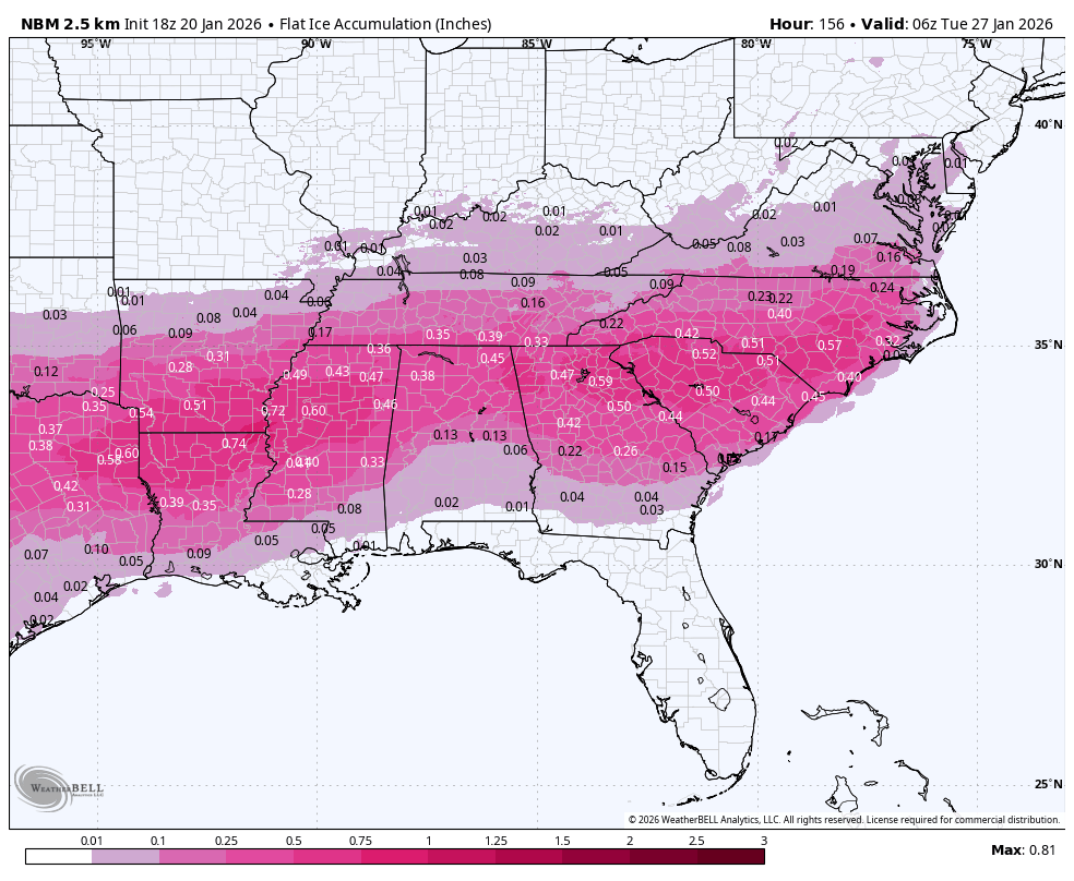
They treat sleet the same as snow. So 3 inches of sleet has the same impact as 3 inches of snow for the products. (That's my guess). and if true, this map isn't awful.Is it only considering snow and ZR and ignoring sleet?
That reminds me of the appetizer in February 2014 before the main snow. Just further north View attachment 186471
Yeah, a precursor of what's to come. IF this comes to fruition, I wonder how many people are going to think, "this is what all the talk has been about...really?!?!?" These little waves can be tricky to forecast, and with cold air pressing in, I wouldn't rule anything out, just yet.For some reason NC just got long range NAM'd on Friday lol. What an idiot. I would ignore this for now
View attachment 186465
Looks good and I appreciate your input. It looks like though you do not believe there will be much of an initial front end thump of snow over NC?If I was to make a map right now, this is what I would go with as of now. Pretty much blending everything together and climo. Just a more for fun type of map though View attachment 186478
Oh yeah, not ruling it out. Just glancing at it, going “ha, alright”, and moving on.Yeah, a precursor of what's to come. IF this comes to fruition, I wonder how many people are going to think, "this is what all the talk has been about...really?!?!?" These little waves can be tricky to forecast, and with cold air pressing in, I wouldn't rule anything out, just yet.
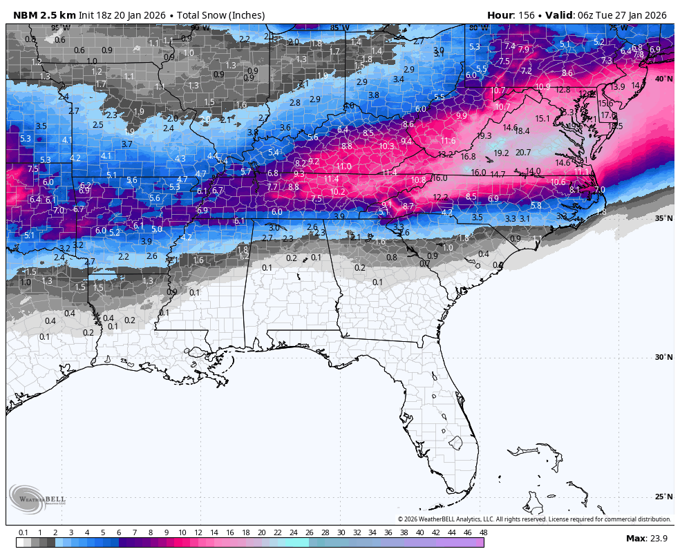
Kinda hard to believe in that small amount of ZR with the lack of snow in areas. Is it not counting sleet?Looks good. Here's the latest National Blend of models:
The Mid-Atlantic crew are celebrating like crazy on Twitter trying to dunk on southern mets/commentators. But, don't think we're done with slight shifts N/S

Looking at the temp 10th-90th percentile spread on Pivotal for the Icon-EPS 18z, I can see some upper end temps on Saturday and Sunday in the 50's (even a 62) and 40's for just south of Atlanta. No idea how many iterations of these temps occur, but there is still a decent chance of nothing but rain for Atlanta at this range, I think.ICON-EPS shifted south a tad it seems


