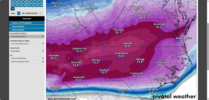
I'm feeling more an more confident : Early thoughts are not set in stone. But thanks to the mega qpf 1.5-2.0 The low end for my immediate area up to Gboro is a foot of snow/mixed with some crust. Think if it sleets, I'll get the high ratio sleet 5:1 , perhaps 6:1.
If we stay all snow, we can net 15-18 inches.
Surface Cold as good as you can get , is a lock. Check that one off. I'm watching qpf trends, all indications are we max 1.5+ as of right now. Then biggest hurdle is keeping the sleet away. It is arms reach away every model run, with some kissing us on the cheek. Gonna take a couple days to iron out ptype breakdown. I feel as good this morning we can stay all snow as Ive felt so far, but that can flip at 12z.
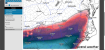
The storm that produced the surface conditions most closely to what we will see from this weekend in the Triad , was the Blizzard of 96 when it rolled through here. Had about 10-12 mostly snow, with thick crust of sleet.
Course if we stay all snow, theres several to draw from.
For us it's a definite High Impact winter storm coming. No doubt. It's just a wait an see if we can luck up stay all snow v/s how much sleet gets involved/ how long/ sleet ratio.
Already had to contract out plowing ( @ powerstroke). Those guys equiptment gonna get put to test pushing this weighty stuff around. They gonna make Bank to.
Folks on GA/AL line area over to western Atlanta. Could be in really Really Big Trouble here.