Gfs warm nose is less warmGfs on the other hand shows 4 to 5 inches of sleet lol
View attachment 186163
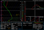
Gfs warm nose is less warmGfs on the other hand shows 4 to 5 inches of sleet lol
View attachment 186163

Yeah the ol warm nose will likely be poorly handled on the GFS
Thats sunday am. Why ignore all day sat and sat night though when its NOT that warm? He nor i is saying it won't change to freezing rain Sunday but if sat and sat night isn't a sleet sounding then I'll eat my socks.The warmest air is above 850mb. Around 800mb. And it is very warm, nearly 10C max. If you completely melt snowflakes, they won’t refreeze on the way down. They’ll just drop below freezing, supercooled, and freeze on contact with surfaces.
Sleet requires partially frozen snowflakes to refreeze (much easier to refreeze a partially melted snowflake vs a raindrop).
Honestly I’m not trusting any of these global models on specific warm nose intensity or CAD strength.Yeah the ol warm nose will likely be poorly handled on the GFS
Thanks for that explanation. Interesting! But you showed me the sounding at 132, when I agreed with the Euro’s ZR. Can you please show a sounding for between hours 114 and 126, when I think the Euro ptype should be sleet?The warmest air is above 850mb. Around 800mb. And it is very warm, nearly 10C max. If you completely melt snowflakes, they won’t refreeze on the way down. They’ll just drop below freezing, supercooled, and freeze on contact with surfaces.
Sleet requires partially frozen snowflakes to refreeze (much easier to refreeze a partially melted snowflake vs a raindrop).
Why are the apps warmer than surrounding areas? Something to do with this type of surface high or with the precip or something?One thing of note that I'm not seeing more consistently is how early temps go below the freezing mark on Saturday.
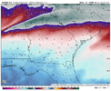
Everyone above the I-20 corridor is at or below freezing by Saturday afternoon.
View attachment 186133
Sure an onset of sleet or sleet/snow is possible, but the bulk of the qpf comes on Sunday morning which is why I picked those soundings.Thats sunday am. Why ignore all day sat and sat night though when it’s NOT that warm? He nor i is saying it won't change to freezing rain Sunday but if sat and sat night isn't a sleet sounding then I'll eat my socks.
Thanks for that explanation. Interesting! But you showed me the sounding at 132, when I agreed with the Euro’s ZR. Can you please show a sounding for between hours 114 and 126, when I think the Euro ptype should be sleet?
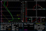
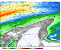
As you said Getting too far into details like this when its so far out is probably silly but we dont get many of these so what the hell lol. Here is the 24 hour totals ending at 09z sunday..that's a lot of sleet.Sure an onset of sleet or sleet/snow is possible, but the bulk of the qpf comes on Sunday morning which is why I picked those soundings.
I assume you are speaking of far western North Carolina, Cherokee County, etc? There is a large valley that runs through there along the Valley and Hiwassee rivers. The large Georgia chain to the southeast and the Cohutta range to the west block the low level cold.Why are the apps warmer than surrounding areas? Something to do with this type of surface high or with the precip or something?
Sure an onset of sleet or sleet/snow is possible, but the bulk of the qpf comes on Sunday morning which is why I picked those soundings.
But ~half of the wintry qpf in ATL area (as much as ~1.2”) on the 0Z Euro falls between 10AM Sat and 4AM Sunday, when I think the WxBell Euro should be showing mainly sleet instead of ZR.
Any stronger of a CAD/Surface High near the Carolinas, and Central GA gets baja blasted with ice.
View attachment 186167
There’s really no point of even having this discussion this soon. This will come down to only a few degrees and we won’t have a good handle on ptype until we’re probably 24-36hrs out.

GA - on the sounding, the temperature lines slant to the right - that’s where the name Skew-T diagram comes from (the lines are skewed directionally). So on that sounding, the 850mb temperature looks more like +2CThanks for posting the hour 126 sounding. I think I see where the problem may be. First, I’ll repost that sounding:
View attachment 186173
Is the sounding showing the 850 mb temp to be way up at ~+9 C? Am I reading that right? If so, there’s a major discrepancy between the sounding’s 850 mb temp and the WxBell Euro 850 mb temp map, itself! Check this out: the map below shows ATL’s 850 at only +1C, which is why I was saying it should be sleet. If it had shown +9C, I’d absolutely agree on ZR. Why are the sounding and the map below 8C apart?!?
View attachment 186175
Ah I was about to do my bit! Anyways here's a sample sounding indicating what our thoughts are:GA - on the sounding, the temperature lines slant to the right - that’s where the name Skew-T diagram comes from (the lines are skewed directionally). So on that sounding, the 850mb temperature looks more like +2C
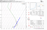
Ah I was about to do my bit! Anyways here's a sample sounding indicating what our thoughts are:
At the 850mb line, it's naively sitting at +8C. However, in relation to the separation from the slanting freezing line, it's only separated by maybe a degree or two!
View attachment 186176
GA - on the sounding, the temperature lines slant to the right - that’s where the name Skew-T diagram comes from (the lines are skewed directionally). So on that sounding, the 850mb temperature looks more like +2C
Ah I was about to do my bit! Anyways here's a sample sounding indicating what our thoughts are:
At the 850mb line, it's naively sitting at +8C. However, in relation to the separation from the slanting freezing line, it's only separated by maybe a degree or two!
View attachment 186176
Thank you for helping me learn something. I really appreciate the detailed explanation. Understanding latent heat or the heat of transformation plays so tightly into this and it's hard to understand.Ahhh. Thanks, I learned something new about reading temps on a sounding! Thus, the sounding and map agree after all.
So, applying what I just learned, it looks like these for hour 126 at ATL:
500 mb: -11C
550 mb: -8C
600 mb: -4C
650 mb: -1C
700 mb: +3C
750 mb: +5C
800 mb: +7C
850 mb: +1C
900 mb: -6C
925 mb: -8C
950 mb: -8C
1000 mb: -5C
2m: -4C
So, per that sounding, it says “best guess” ZR despite the raindrop falling through well below freezing air for ~the last kilometer. So, as Bouncycorn taught me, it being completely melted snow causes it to take longer to refreeze than if it were only partially melted. The >0C air between ~650 mb and 850 mb is enough to completely melt the snowflakes. So, despite the very cold last km, it hits the sfc as supercooled rather than sleet. Fascinating, I love this stuff!
I’d like to ask you and others about how realistic the Euro’s sharp warm nose temperature rise down to 800 mb followed by a sharp temperature fall from 800 mb to 925 mb is. Opinions?
I do have to wonder what that area north of ATL looks like especially given the temps are much lower. Hoping this warm nose is overdone to spare someThanks for posting the hour 126 sounding. I think I see where the problem may be. First, I’ll repost that sounding:
View attachment 186173
Is the sounding showing the 850 mb temp to be way up at ~+9 C? Am I reading that right? If so, there’s a major discrepancy between the sounding’s 850 mb temp and the WxBell Euro 850 mb temp map, itself! Check this out: the map below shows ATL’s 850 at only +1C, which is why I was saying it should be sleet. If it had shown +9C, I’d absolutely agree on ZR. Why are the sounding and the map below 8C apart?!?
View attachment 186175
@Wild Weather Monger
@Makeitsnow
This right here. I wanted to come here and remind everyone that while yes CAD wedges are typically low level cold drivers, we don’t typically have CAD events this strong. Surface level temps down into the teens for mby and NC? In the low to mid 20’s back into ATL suburbs? There’s going to be a lot of WAA but the depth of this CAD due to the shear amount of ridiculous arctic air associated with it is going to help cool the column much more than just the BL temps. The last super CAD event from Jan 2022 did this. I was supposed to be all sleet and ZR. Ended up with over 8” of snow before finally flipping over and that was along the 85 corridor. My new home that I live in now near Landrum got well over a foot. This is looking to be an even stronger CAD event. I really think when we get into the HI-RES wheel house we are going to see that snow line hold out a lot longer along the 85 corridor and get some ridiculous totals.Honestly I’m not trusting any of these global models on specific warm nose intensity or CAD strength.
High res models will likely have a much better handle on this.
Well as long as we dodge the ice, I mean most people will likely keep power with only 6-10" of Snow.This right here. I wanted to come here and remind everyone that while yes CAD wedges are typically low level cold drivers, we don’t typically have CAD events this strong. Surface level temps down into the teens for mby and NC? In the low to mid 20’s back into ATL suburbs? There’s going to be a lot of WAA but the depth of this CAD due to the shear amount of ridiculous arctic air associated with it is going to help cool the column much more than just the BL temps. The last super CAD event from Jan 2022 did this. I was supposed to be all sleet and ZR. Ended up with over 8” of snow before finally flipping over and that was along the 85 corridor. My new home that I live in now near Landrum got well over a foot. This is looking to be an even stronger CAD event. I really think when we get into the HI-RES wheel house we are going to see that snow line hold out a lot longer along the 85 corridor and get some ridiculous totals.
And it's warmer/more amped. Warm nose goes up more too.View attachment 186180This run be be wetter again
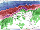
I checked my sounding. It flips me on the pretty map at hr 108. I’m still a solid snow sounding until hr 117. That’s 8+ hours of additional snow under the heaviest rates.And it's warmer/more amped. Warm nose goes up more too. View attachment 186181
We can only hope that if it's not gonna be Snow, it's sleet instead of the Ice. We need those columns to work in our favorThe GFS is overdoing sleet but the Euro is under doing it as much as the GFS is over doing it. Now it’s probably because these models cant predict sleet at all, but I favor sleet over a large area showing freezing rain. I remember 2014 February. Columbia was supposed to be in the bullseye of freezing rain but we were saved by 2-3 inches of sleet.
