Atlanta is trending to a sleet miss with this look... got to look at the 850 though. This might be our saying grace ATL?
-
Hello, please take a minute to check out our awesome content, contributed by the wonderful members of our community. We hope you'll add your own thoughts and opinions by making a free account!
You are using an out of date browser. It may not display this or other websites correctly.
You should upgrade or use an alternative browser.
You should upgrade or use an alternative browser.
Wintry January 23rd-27th 2026
- Thread starter SD
- Start date
A foot of snow followed by an inch and a half of sleet??? That’s insanity
3” of ice? Maybe you mean sleet?I actually experienced that around Christmas 1998. We ended up with 3 inches of ice over a 36 hour period. Zr with temps in the mid 20s is a whole different world than 31, 30 etc.
3” of ice is something that causes giant transmission line structures to crumple. Like Canada back in the late 90s.
Attachments

Holy guacamole
and looking at soundings, this is definitely all ZR around Atlanta. Big warm nose.

and looking at soundings, this is definitely all ZR around Atlanta. Big warm nose.
That is mainly sleet for the Atlanta area.
What does 2.5” ZR on top of 6” snow even look like? Has that been done anywhere since the little ice age?
WAA a concern for Alabama around 132 hours. Just wondering if that’s possible with that strong of a push of arctic air?? Kinda confusing the storm took more of a suppressed track.
Sky86
Member
Wouldn't that lead to more snow in the deep CAD areas?
LukeBarrette
im north of 90% of people on here so yeah
Meteorology Student
Member
2024 Supporter
2017-2023 Supporter
I will say that the progression of the system is nowhere near being locked down. There seems to be a trend of latitude gain in the second half of the system. Probably a lot to do with the fact that the Baja low is more phased with the northern branch.
It's a dangerous game, but the EURO shows how bringing the Baja low out can be go big or go home. A sweet, sure thing slider versus a historic SE snowstorm. This is especially true in Ga. and SC.Oh my, what a suite of 0z runs! I would have loved to see the GFS another tick south than north, and that Baja Low is trying to cause mischief. The Euro high is so strong it is able keep a good press but I would rather that low stay farther back. Good to see the Euro trending better with the AI models. But oh my goodness at what is being shown, this amount of precip is going to cause problems across this section of the country. It's truly a shame we can't keep this warm nose away and have it all be snow; would be incredible!
Makeitsnow
Member
There is a warm nose at 700 to 800mb so a ton of sleet...especially to the north of townWouldn't that lead to more snow in the deep CAD areas?

Brent
Member
I might be a little too far north here to be completely honest but I'll tell you one thing it's way too close to call on whether we can go historic here... We still got 3 days haha. I've seen entire storms show up and disappear in this range
Seeing the Euro still historic here too wow
Seeing the Euro still historic here too wow
 This is 110% a ZR sounding with no sleet or sleet mix. Most around ATL look like this on the 00z ECMWF
Nerman
Member
That sounds like 2005, I think it was in February. Atlanta was a sheet of ice for days.I can remmeber one event, I think 2004 this happened and the wedge made it central Eastern AL and NE AL. I remember actually forecasting that to happen. Wish I could remember what particular storm that was.
WxBlue
Meteorologist

Here's the FRAM
This storm is starting to remind me of January 28-29, 2005 lowkey. I don’t remember if it was an overrunning event, I’m assuming it was because it was a long duration from Friday-Sunday. Unlike that storm, it will remain significantly colder afterwards which makes this scenario much worse if it materializes this way.Man what….. Heavy ZR and below 25???View attachment 186130View attachment 186131
Makeitsnow
Member
That is by Sunday afternoon...it is almost surely sleet most of the night sat..even for the perimeter. Absolutely mess though.View attachment 186145This is 110% a ZR sounding with no sleet or sleet mix. Most around ATL look like this on the 00z ECMWF
3 inches for frz rain on come on Ill go ahead and start cutting down all the trees in my county now!!! Honestly we all better start praying the mid layers cool off are the whole of the SE will be in a world hurt there won't be enough poles/lines to restore power for a month
John1122
Member
The punch of cold behind the system seems to have disappeared in Tennessee that run. Rather than plunging into the lower teens, that ran held temps near 30 into Monday morning. Not sure what happened there vs 12z.
NBAcentel
Member
Looks like the first part of the system is trending lower in latitude, thanks to the Atlantic Canada troughing/heights in the Atlantic trending lower (this is running up a front end thumper trend for NC/the upstate)I will say that the progression of the system is nowhere near being locked down. There seems to be a trend of latitude gain in the second half of the system. Probably a lot to do with the fact that the Baja low is more phased with the northern branch.


But the slowing trend and more interaction is resulting in a higher QPF event, and as you mentioned, a more poleward response after

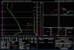
E and NE Atlanta burbs may start with a couple of hours of snow before changing over to sleet and freezing rain at onset, verbatim. This sounding is 40 miles ENE of Atlanta. Close.
![soundings-[33.8,-83.8]-ecmwf_full-sfct_b-imp-us_se-2026012000-114.png](https://southernwx.nyc3.digitaloceanspaces.com/data/attachments/186/186163-00974c699c2d7beface47a25263cae81.jpg "soundings-[33.8,-83.8]-ecmwf_full-sfct_b-imp-us_se-2026012000-114.png")
LongRanger
Member
In reality of what these clown maps are showing, Can't we cut those totals in half?
WxBlue
Meteorologist
FRAM map I posted is usually a lot closer to the actual amount of ice accretion... but yeaaaah, 1-2" of ZR is still pretty insane.In reality of what these clown maps are showing, Can't we cut those totals in half?
Yes, think that prolly safe to say.In reality of what these clown maps are showing, Can't we cut those totals in half?
billyweather
Member
Euro trended much better for folks north of 85 in upstate SC.


View attachment 186145This is 110% a ZR sounding with no sleet or sleet mix. Most around ATL look like this on the 00z ECMWF
I agree with what you’re showing at 138 being ZR and from ~129-132 (starting earliest at airport and later further N) to the end on the 0Z Euro is ZR rather than sleet for ATL . But the precip falling before hour 132 is mainly sleet imho per 850s/925s/2m temps. So, I estimate ~1/2 the ATL precip is favoring sleet imho (>1” qpf) and other 1/2 is favoring ZR (also >1” qpf) on this run.
Thus WxBell Euo map of hardly any sleet is a joke. There should be a couple of inches of sleet in some of this area where it has just a few tenths and ATL sub 0.1” is laughable:

Thus I think this ZR is overdone but still 1/2 of that would be very bad:

EPS mean with a big increase, now over 1” for many in north Georgia. 
WxBlue
Meteorologist


Atlanta temps at height of storm
Upstate
Upstate
ATL is -3 to -9 C at 925 mb hours 111-129 with 2m as cold as 23-24 F and 850s mainly +2C or colder is not going to produce virtually all ZR instead of mainly sleet imho. Someone please tell me why this wouldn’t be the right way to look at it. I think there may be a problem with the WxBell Euro precip types.
How is liquid going to reach the ground with this setup?
Hey sleet lover Tony @dsaur I think you need to call WxBell and/or ecmwf, themselves and get this corrected. You have a lot of clout when it comes to defending sleet.")
How is liquid going to reach the ground with this setup?
Hey sleet lover Tony @dsaur I think you need to call WxBell and/or ecmwf, themselves and get this corrected. You have a lot of clout when it comes to defending sleet.
Last edited:
Yes, that's sleet, no doubt.ATL is -3 to -9 C at 925 mb hours 111-129 with 2m as cold as 23-24 F and 850s mainly +2C or colder is not going to produce virtually all ZR instead of mainly sleet imho. Someone please tell me why this wouldn’t be the right way to look at it. I think there may be a problem with the WxBell Euro precip types.
One caveat, particularly with the EURO as amped as it was this run, there is a chance it's underestimating the WAA, and who knows, perhaps even underestimating the low-level CAD. Crazy? IDK.
Forevertothee
Member
GSP
Key message 4: A potential winter storm system could affect the area
this weekend but details remain highly uncertain.
The bigger story for the forecast continues to be the potential for
a winter storm to sweep across a wide swath of the south, from the
central CONUS to the Carolinas. What we know at this point is a
signal in model guidance has pointed to a strong continental polar
(cP) air mass spilling into the central portion of the U.S. and
spreading eastward. Meanwhile, moisture appears to stretch over the
south and southeast ahead of the frontal boundary. Somewhere along
this frontal boundary, wintry precipitation will likely form. Now,
this is where the uncertainty comes into play as there are many
factors that will change and directly influence this system for our
area. The primary factor being the location of the transition zone
from snow to a wintry mix, involving sleet and ice. Current model
guidance from the GFS has shifted the transition zone further north,
bringing the potential for more of an ice event than snow. The EURO
keeps the snow as the primary p-type. Many of the GEFS members show
a mix of ice and snow. The main point is that yes, the model
guidance is signaling for a potential winter storm stretching over
the weekend. There is also the possibility for the area of high
pressure to extend further south, which also could cutoff
precipitation chances entirely. It`s a low chance, but still in the
realm if possibilities. But, despite these forecast tools, there is
still much uncertainty to where the transition zone sets up, which
directly impacts how much snow vs ice vs nothing there could be.
Another factor increasing confidence in this potential winter storm
is the cold air that is expected to be in place. Unlike systems
recently where there was a chance for snow, the environment lacked
the cold air required for any wintry precip to develop. This is
looking to not be the case for this potential event. Currently, the
NBM has increased probabilities of accumulations that could bring
about warnings for snow (40%) and ice (35%). So, overall, there is a
strong signal for a possible winter storm that could impact the area
over the weekend, but details on snow/ice/sleet remain unclear this
far out.
Columbia
Key Message 2: The trend continues towards a potentially significant
winter storm this weekend.
Overview: The forecast thinking has not changed much for the weekend
system with potential for an impactful winter storm continuing. The
overall synoptic pattern is quite consistent across all guidance
with a deep digging trough in the NE CONUS, strong confluence and an
associated strong surface high in the central CONUS, and an ejecting
cutoff shortwave in the SW CONUS. This patterns sets up a broad
overrunning scenario as the arctic high digs southeastward
presenting an all-hazards winter storm potential for much of the
southern and eastern US, including GA and SC as strong cold air
damming sets up.
Trends and Possible Impacts: Guidance remains in above-typical
agreement over the potential impacts from this system, with historic
analogs and climatology concurring; this setup distinctly
favors mixed precip with snow-sleet-freezing rain potential.
While in good agreement for a 96+ hour forecast, there is a
spectrum of impact potential in the guidance. The GEFS and ECE
favor a stronger CAD scenario, with notably colder surface temps
and much longer duration. The Canadian Ens along with much of
the AI guidance favors weaker CAD and warmer surface temps
throughout the potential event; it should be noted that even
these warmer solutions would still yield some impactful wintry
precip in parts of the area. So currently, the spectrum of
potential ranges from a "typical" low- moderate impact ice event
for parts of our area to a much more widespread and highly
impactful system.
Forecast Challenges: While there is good agreement in the overall
setup, a few of the players in this game are notoriously
tricky. The first being the extent and intensity of the surface
high, which then directly impacts CAD over our area. The second
being the SW CONUS ejecting shortwave and associated
cyclogenesis which would impact precip location and therefore
p-type. The GEFS and Canadian ensemble handle these features in
opposite fashions and their associated p-type and surface
differences result from that.
Summary: Guidance continues to be in above-typcal agreement over
much of this forecast but subtle differences result in a range of
impact potential. Confidence is already fairly high that some areas
of SC and GA will see winter weather this weekend. Concerningly,
unlike many southern winter events, the ceiling for this event
is very high with significant impact potential.
The warmest air is above 850mb. Around 800mb. And it is very warm, nearly 10C max. If you completely melt snowflakes, they won’t refreeze on the way down. They’ll just drop below freezing, supercooled, and freeze on contact with surfaces.ATL is -3 to -9 C at 925 mb hours 111-129 with 2m as cold as 23-24 F and 850s mainly +2C or colder is not going to produce virtually all ZR instead of mainly sleet imho. Someone please tell me why this wouldn’t be the right way to look at it. I think there may be a problem with the WxBell Euro precip types.
How is liquid going to reach the ground with this setup?
Hey sleet lover Tony @dsaur I think you need to call WxBell and/or ecmwf, themselves. And get this corrected.
Sleet requires partially frozen snowflakes to refreeze (much easier to refreeze a partially melted snowflake vs a raindrop).
Attachments
Makeitsnow
Member
Gfs on the other hand shows 4 to 5 inches of sleet lolI agree with what you’re showing at 138 being ZR and from ~129-132 (starting earliest at airport and later further N) to the end on the 0Z Euro is ZR rather than sleet for ATL . But the precip falling before hour 132 is mainly sleet imho per 850s/925s/2m temps. So, I estimate ~1/2 the ATL precip is favoring sleet imho (>1” qpf) and other 1/2 is favoring ZR (also >1” qpf) on this run.
Thus WxBell Euo map of hardly any sleet is a joke. There should be a couple of inches of sleet in some of this area where it has just a few tenths and ATL sub 0.1” is laughable:
View attachment 186152
Thus I think this ZR is overdone but still 1/2 of that would be very bad:
View attachment 186153

ATL is -3 to -9 C at 925 mb hours 111-129 with 2m as cold as 23-24 F and 850s mainly +2C or colder is not going to produce virtually all ZR instead of mainly sleet imho. Someone please tell me why this wouldn’t be the right way to look at it. I think there may be a problem with the WxBell Euro precip types.
How is liquid going to reach the ground with this setup?
Hey sleet lover Tony @dsaur I think you need to call WxBell and/or ecmwf, themselves and get this corrected. You have a lot of clout when it comes to defending sleet.
With that profile you’re basically in classic sleet/mixed wintry territory, not rain.
Surface/low levels:
2
m
temps around
23
−
24
∘
F
(
−
4
to
−
5
∘
C
) and 925 mb between
−
3
and
−
9
∘
C
give you a pretty deep subfreezing layer near the ground.
Aloft: 850 mb at around
+
2
∘
C
or colder is a modest warm nose—warm enough to partially or fully melt snowflakes for a time, but not a huge, deep warm layer.
In that setup:
If the 850 mb warm layer is pronounced and above freezing for a decent depth: snowflakes melt into raindrops in that layer, then fall into a deep subfreezing layer below (925 mb down to the surface). That favors sleet (ice pellets) as the dominant type, because there’s plenty of time for refreezing before reaching the ground.
If the warm nose is weak/marginal (hovering near
0
∘
C
or just briefly above): you’d get mostly snow, possibly mixed with sleet at times.
Freezing rain is unlikely here, because your near-surface cold layer is too deep and too cold—drops would almost certainly refreeze before hitting the ground.
So the short version: with
−
3
to
−
9
∘
C
at 925 mb, low 20s at the surface, and 850 mb around
+
2
∘
C
or colder, you’re looking at primarily sleet and snow, with sleet favored if the warm nose is solidly above freezing
Took the lazy copilot approach it's says most sleet more likely then frz rain at least in that window
The shortwave diving down from MT into the Baja wave ends up tilting our heights in the SE which at least partially prevents us from having a more sliding, full snow event across NCLooks like the first part of the system is trending lower in latitude, thanks to the Atlantic Canada troughing/heights in the Atlantic trending lower (this is running up a front end thumper trend for NC/the upstate)View attachment 186149View attachment 186148View attachment 186147
But the slowing trend and more interaction is resulting in a higher QPF event, and as you mentioned, a more poleward response after View attachment 186151

But it’s a catch-22 because the southern stream wave tilting adds more confluent flow into the 5050 low in E Canada. I like to refer to this as double-confluence. The flow across the Great Lakes is already confluent, but the flow off the SS wave adds to it, so this helps to strengthen the sfc high and damming signature feeding lower level cold south

SimeonNC
Member
Temps to get about 16F at their lowest in the CLT metro area at the height of the storm.
CltNative90
Member
Whoever ends up under that eventual freezing rain bullseye needs to hope and pray for moisture robbing convection in the Gulf creating a dry slot when the strongest WAA is coming through.
A lot of the freezing rain duration showing up on the Euro north of I-20 in the Carolinas and NE Georgia is actually sleet per the soundings for a time before the full extent of WAA takes over. Areas to the north/ east will undoubtedly hold on to sleet longer than areas to the south/ west, where the wedge is shallower. The wedge depicted is strong enough sleet will up saving the day for some that will be sweating the catastrophic freezing rain depictions leading up to the event.
A lot of the freezing rain duration showing up on the Euro north of I-20 in the Carolinas and NE Georgia is actually sleet per the soundings for a time before the full extent of WAA takes over. Areas to the north/ east will undoubtedly hold on to sleet longer than areas to the south/ west, where the wedge is shallower. The wedge depicted is strong enough sleet will up saving the day for some that will be sweating the catastrophic freezing rain depictions leading up to the event.