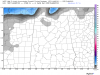
Can you post southeast TN pleaseSure it is, many runs have given that area very very little. Here is the 12Z to show the difference.
-
Hello, please take a minute to check out our awesome content, contributed by the wonderful members of our community. We hope you'll add your own thoughts and opinions by making a free account!
You are using an out of date browser. It may not display this or other websites correctly.
You should upgrade or use an alternative browser.
You should upgrade or use an alternative browser.
Wintry Midsouth Winter Storm January 12th-13th
- Thread starter Storm5
- Start date
Stormlover
Member
that was the 12Z, I was showing what an improvement the 18Z up above wasCan you post southeast TN please
MRX hasnt issued anything.
Stormlover
Member
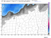
hrrr at 8am

NWMSGuy
Member
Could be completely wrong but seems like to me the Cold air is trying to work in quicker with each new model run.
Stormlover
Member
agreedCould be completely wrong but seems like to me the Cold air is trying to work in quicker with each new model run.
Stormlover
Member
from Brad Travis in Huntsville:
Friday is now a First Alert Weather Day! Latest data coming in is trending towards a faster changeover to snow and wintry mix. Roads could become hazardous in the Shoals by 9am. Metro by 11am. NE Alabama by 1pm. Temperatures could fall into the upper 20s by 4pm and freeze bridges and overpasses. The roads may not have time to dry before the freezing temps move in. Video update will up up on this page soon. Any problems on areas roads will stay that way until the mid morning hours on Saturday.

Friday is now a First Alert Weather Day! Latest data coming in is trending towards a faster changeover to snow and wintry mix. Roads could become hazardous in the Shoals by 9am. Metro by 11am. NE Alabama by 1pm. Temperatures could fall into the upper 20s by 4pm and freeze bridges and overpasses. The roads may not have time to dry before the freezing temps move in. Video update will up up on this page soon. Any problems on areas roads will stay that way until the mid morning hours on Saturday.
Storm5
Member
Gfs was a nice hit for Tennessee
Sent from my SM-J320VPP using Tapatalk
Sent from my SM-J320VPP using Tapatalk
Stormlover
Member
and starting back into Alabama...might get interestingGfs was a nice hit for Tennessee
Sent from my SM-J320VPP using Tapatalk

Storm5
Member
Jason Simpson seems realistic

Sent from my SM-J320VPP using Tapatalk

Sent from my SM-J320VPP using Tapatalk
Storm5
Member
Memphis hit the low 60s this afternoon , winter storm tomorrow . Gotta love the South
Sent from my SM-J320VPP using Tapatalk
Sent from my SM-J320VPP using Tapatalk
NWMSGuy
Member
AFD out of Memphis
Area Forecast Discussion
National Weather Service Memphis TN
351 PM CST Thu Jan 11 2018
.DISCUSSION...Surface analysis this afternoon places a cold front
stretching from Northeast Missouri back through Southwest Missouri
and into Eastern Oklahoma. Temperatures remain quite mild in the
lower 60s ahead of the cold front. Regional WSR-88D radar trends
indicate rain showers with a few embedded thunderstorms occurring
over Southwest Arkansas and Northeast Texas. Winter weather
potential tonight into Friday remains the predominant concern in
this afternoon`s forecast issuance.
A strong cold front will move through the Mid-South tonight.
Arctic air will begin to filter into portions of the Lower
Mississippi Valley over Northeast Arkansas later this evening and
into the remainder of the Mid-South overnight into Friday morning.
Models have remained in decent consensus at the onset of
precipitation. Short term model soundings suggest precipitation
will begin to transition from rain to a freezing rain as the cold
arctic air filters below an elevated warm nose. As the airmass
cools freezing rain will transition towards sleet then snow before
ending. A Winter Storm Warning has been issued as ice
accumulations up to one tenth of an inch, and snow and sleet
accumulations between 1-3 inches are expected across West
Tennessee, a portion of East/Northeast Arkansas and DeSoto County
Mississippi. The greatest snow and sleet accumulations are
expected across portions of Northwest Tennessee near the
Tennessee River. Winter Weather Advisories are in effect across
much of the remainder of the Mid-South. Impacts will begin to be
felt first on elevated surfaces such as bridges and overpasses and
as ground temperatures will initially be above freezing.
Models indicate this winter precipitation will begin to taper off
in the form of snow before ending Friday afternoon. Latest
GFS/ECMWF/Canadian/SREF model solutions indicate a potential for
precipitation to lag across the area a bit during the day Friday
as a deformation axis may move across the region. Later shifts
will continue to monitor trends and adjust precipitation amounts
if warranted.
Cold arctic high pressure will remain in place across the region
for the upcoming weekend with temperatures struggling to reach
freezing. This will cause any leftover precipitation on the ground
to refreeze on surfaces.
Long term models indicate a potential for additional wintry
precipitation Monday night as an Alberta Clipper cold front moves
through the region and some overrunning ahead of a warm front next
Thursday night.
Stormlover
Member
Huntsville at 8PM tomorrow night..RPM

Huntsville at 8PM tomorrow night..RPM
Well, "Arab" looks cold. Why would they be colder than to the North? Silly RPM!
Stormlover
Member
Arab is higher up, on Brindley Mountain. RPM knows all. ;-)Well, "Arab" looks cold. Why would they be colder than to the North? Silly RPM!
Storm5
Member
Lol the rpm is horrible i don't know why tv stations use it. I'd use the JMA for short term guidance before I used the rpm
Sent from my SM-J320VPP using Tapatalk
Sent from my SM-J320VPP using Tapatalk

Storm5
Member
Latest HRRR does not look too hot for those wanting wintry in extreme Northern Alabama and lower Tennessee

Sent from my SM-J320VPP using Tapatalk

Sent from my SM-J320VPP using Tapatalk
ForsythSnow
Moderator
LOL. You would go for a low resolution model over a high one? All joking aside, it isn't that good. I'd use the HRRR and WRF products as well as the RGEM and NAM in combo. I'm putting more weight on the HRRR this go because I don't get snow and also it did better than the NAM with its precip last storm.Lol the rpm is horrible i don't know why tv stations use it. I'd use the JMA for short term guidance before I used the rpm
Sent from my SM-J320VPP using Tapatalk
Stormlover
Member
he's going by old data, not the newest...watch that increaseJason Simpson seems realistic
Sent from my SM-J320VPP using Tapatalk
LOL. You would go for a low resolution model over a high one? All joking aside, it isn't that good. I'd use the HRRR and WRF products as well as the RGEM and NAM in combo. I'm putting more weight on the HRRR this go because I don't get snow and also it did better than the NAM with its precip last storm.
Cut at least 1/3rd of the precipitation off the NAM in a situation (amplified situation) like this, but use the temperature profiles.
RollTide18
Member

Storm5
Member
I'm going to northern Marshall county tomorrow afternoon maybe I'll see a flake
Sent from my SM-J320VPP using Tapatalk
Storm5
Member
If he goes by the newest he might cut that down. Freezing rain looks to be the biggest issue. Someone in North Alabama will catch the dry slot and it wont be prettyhe's going by old data, not the newest...watch that increase
Sent from my SM-J320VPP using Tapatalk
RollTide18
Member
I'm going to northern Marshall county tomorrow afternoon maybe I'll see a flake
Sent from my SM-J320VPP using Tapatalk
Haha well good luck on #FlizzardWatch18
Stormlover
Member
No, trend is very good for here. Good feeling about this.If he goes by the newest he might cut that down. Freezing rain looks to be the biggest issue. Someone in North Alabama will catch the dry slot and it wont be pretty
Sent from my SM-J320VPP using Tapatalk
Storm5
Member
Very good ??? Have you seen the hrrr? Dry slot cityNo, trend is very good for here. Good feeling about this.
Sent from my SM-J320VPP using Tapatalk
Storm5
Member
Hope y'all get something though. Should be fun to watch
Sent from my SM-J320VPP using Tapatalk
Sent from my SM-J320VPP using Tapatalk
Storm5
Member
Rgem

Sent from my SM-J320VPP using Tapatalk

Sent from my SM-J320VPP using Tapatalk
Xtreme Weather
Member
Sure it is, many runs have given that area very very little. Here is the 12Z to show the difference.
Omg come on storm only 2-3 runs of the NAM last 36-48 hours have showed little to no accumulation in NW AL
2 or 3!
At least 3 runs spit out 6-8" or more in NW AL the 18z run was nothing big or different (or big) compared to some totals its put out. I'm not going to post them and eat up bandwidth/waste my time but everyone can go to TT (I used the 12k NAM) and view previous model runs to verify.
Last edited:
I will take my three flakes and enjoyRgem
Sent from my SM-J320VPP using Tapatalk
")
You're right. If there's a dry slot, HRRR will sniff it outVery good ??? Have you seen the hrrr? Dry slot city
Sent from my SM-J320VPP using Tapatalk
Brent
Member
Radar starting to light up just north of Dallas up to the Red River...Small area of a few counties under a WWA...Some areas are sleet, but temps are above freezing....All moving East...Didn't know if this was expected or not?? Paging Brent...Paging Brent
FWD had a WWA out all day but its falling apart and the advisory is now cancelled not much to write home about in Dallas
Phil Connors
Member
Can someone post the current 500mb map
olhausen
Member
I got up to 66 and sitting at 64 atm. Supposed to be below freezing by the time I get up tomorrow morning.Memphis hit the low 60s this afternoon , winter storm tomorrow . Gotta love the South
Sent from my SM-J320VPP using Tapatalk
Stormlover
Member
Huge difference in 18Z and 12Z. Just the truth.Omg come on storm only 2-3 runs of the NAM last 36-48 hours have showed little to no accumulation in NW AL
2 or 3!
At least 3 runs spit out 6-8" or more in NW AL the 18z run was nothing big or different (or big) compared to some totals its put out. I'm not going to post them and eat up bandwidth/waste my time but everyone can go to TT (I used the 12k NAM) and view previous model runs to verify.
Attachments
Xtreme Weather
Member
You saidHuge difference in 18Z and 12Z. Just the truth.
Wow, NAM big hit for NW Ala..big improvement
Not what you originally said now you want to time stamp it 18z vs 12z and wiggle around it... JMHO you were trying to hype it up and to me at least read like "breaking news"...Fine ok...But like I quoted to you earlier there was nothing new here
NAM has shown a clear trend over the last couple days for possible wintry impacts and accumulation for NW AL...
Now spin it as you wish (your good at it) but I'm done with this subject...
Xtreme Weather
Member

Can someone post the current 500mb map
Storm5
Member
Hrrr is ugly for North Alabama. Hardly any frozen precip
Sent from my SM-J320VPP using Tapatalk
Sent from my SM-J320VPP using Tapatalk
Yea mega dry slotted.Hrrr is ugly for North Alabama. Hardly any frozen precip
Sent from my SM-J320VPP using Tapatalk