• Hello, please take a minute to check out our awesome content, contributed by the wonderful members of our community. We hope you'll add your own thoughts and opinions by making a free account!

Wintry January 23rd-27th 2026

I really think the upstate and Piedmont crew are going to love when we get in the short range and get the FGEN driven front end snow thump that tends to hold on much longer. Especially if we hold and trend to stronger confluence over the Atlantic. This has the potential to get a lot of people their first foot of snow in a really long time.
Good post. I will say, for the upstate, you are in about the best spot possible ouside of elevation. It's a bit tougher for me and guys west of me like @Oconnexman and @rburrel2 but if we can get that press a bit more, and actually verify, it would be something incredible for the whole upstate. The areas north of I 40 and elevations above 3k have to be feeling good about where they stand. As long as that press continues to show strong and advances the 85 corridor should be in great shape as well.
 
If you find yourself in the ZR camp over the next couple days.. please take it seriously. I was caught in a .6 ice storm last year. It’s scary! Non stop trees cracking with no power and cold conditions getting colder.

Someone is bound for an ice storm and it could be a heck of a lot more than .6 accrual with this type of reestablishing cold air source and high QPF.

Best to prepare NOW before the hustle and bustle gets to the generic public soon. You’ll be glad you did if you end up in the thick of an intense ice storm
 
Looks like the Lowcountry of SC is most likely stuck with ZR right now. Hopefully it trends more toward sleet/snow or even just cold rain!
 
Way too far out for specifics but the finger of precip that shoots out infront of the main precip field, as currently shown on the Euro, will be a beauty. Back in the old EasternWx/AmericanWx days Robert would be honking big time in this feature.

Whoever can get under that will probably get a few inches of snow before the changeover, it could also keep the ice/snow boundary pushed further south too. Just depends on where it sets up
IMG_5415.jpeg
 
Man, this really looks like a truly legendary setup.

You don't see ones like this very often at all. Maybe a few times in a career where you'll see this quantity of cold air couple to a strong enough subtropical jet/southern stream wave over the SW US to back it up. Most of us on this board are long overdue for it.
I've been blessed to be siting ground zero for some whoppers. But it's been since late Feb 2004. I've always wondered what it would be like , now that we have this wx board to experience a Historic SE Winter Storm, see it coming from a few days out. Hope I'm about to find out.
 
Looks like the Lowcountry of SC is most likely stuck with ZR right now. Hopefully it trends more toward sleet/snow or even just cold rain!
KCHS really honking. They have already introduced or plan to introduce freezing rain chances Saturday night into Sunday Morning.


Most impactful is that there is growing concern for a winter weather
event to affect much, if not all, of southeast GA and southeast SC
this weekend. As the aforementioned cold high pressure builds in,
there is increasing likelihood for temperatures to fall below
freezing Saturday night and Sunday morning (potentially mid to upper
20s in some areas) across nearly all of the forecast area in the
presence of ongoing precipitation. Such a setup would set the stage
for a winter weather event, which could be rather significant
depending on how the critical details work out. There is increasing
support for winter weather among both ensembles, deterministic model
runs, as well as in probabilistic guidance. While it is too early to
nail down specific precipitation types and any potential
transitions, model soundings seem to suggest primarily a freezing
rain threat with a shallow sub-freezing layer at the surface and a
prominent warm nose centered around 800-850 mb. As such, the
forecast grids will introduce freezing rain across most of the area
starting Saturday night and continuing through Sunday morning.

It cannot be stressed enough that while the chance of a potentially
significant winter weather event is increasing, there remains
substantial uncertainty regarding the details including timing,
impacted areas, precipitation types, and precipitation amounts. All
of southeast GA and southeast SC should begin to prepare to
experience at least minor winter weather impacts this weekend.
 
FFC from about an hour ago…

Global models are painting a concerning picture of what this
weekend could look like, with an increasingly strong signal for
ice storm potential across at least a portion of the County
Warning Area (CWA). An arctic airmass will spill southward from
Canada across the central and eastern CONUS, reaching as far south
as the Gulf Coast states. Gulf moisture meeting up with and
overrunning this cold airmass suggests the potential for a large,
generally east-to-west oriented corridor of wintry precipitation
across the Gulf Coast and Eastern Seaboard states. Where exactly
this baroclinic zone (the boundary between the cold, dry arctic
air and warmer Gulf air) sets up will govern where precip
transition zones are located.

Other variables that will be at play include...

---> How strong is cold air damming (the wedge)? The cold,
surface-based airmass characteristic of the wedge could increase
frozen precip intensity/accumulations.
---> Will upper-level features like jet streaks or shortwaves aid
in increasing frozen precip intensity/accumulations?
---> What path does a wave of low pressure take along the
baroclinic zone? This would largely determine if this event is
mostly freezing rain or if there is a gradient of frozen and
liquid precip types across the state.

The above variables will likely not come into better focus in
global guidance and regional/hi-res guidance until 1 to 3 days
out. So, currently, we are leaning mostly on ensemble model
guidance rather than deterministic model guidance to gauge the
potential for an impactful winter storm. Several pieces of
probabilistic forecast information from the NBM (National Blend of
Models) that suggest this event is something watch closely
include:

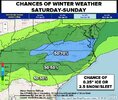
---> 20% to 60% chance for freezing rain accumulations greater
than 0.1" across much of north and central Georgia.
---> 15% to 45% chance for freezing rain accumulations greater
than 0.25" across much of north and central Georgia.
---> 15% to 45% chance for snow accumulations greater than 1"
along and north of the I-20 corridor.

The big picture at this point is that impactful wintry weather is
possible this weekend, and residents should monitor the forecast
closely through the week. Changes to the forecast are likely, so
do not focus on predictions of accumulations or timing of precip
type transitions at this time.


They already have rain/freezing rain in the forecast grid for Atlanta on Sat night/Sunday. (50-70% chance)
 
Last 4 runs here on Weathernext. This is likely counting snow and sleet, with sleet accumulation calculated as 10:1 when it should be 3:1 - but I'm guessing. But you can at least see the broad trends of course

View attachment 185753
Snow is going to be higher than 10:1 for many, as much as 15:1 plus
 
6b1f062437b1a07542e4860e0abf880d.jpg

EC AI ENS MEAN is pure insanity this is out to HR174.
 
a cold rain in ATL is more likely than all snow, in my opinion.
With how strong the high is at the head of the CAD corridor, less likely that there is cold rain vs ZR / sleet. I wish it would suppress or amp up the WAA.. but.. someone, a lot of someones are going to lose big in this storm. By lose, I mean waking up to no power and 1/2" ice over everything or more.

I'm an hour east/northeast in AThens and am making preparations for the absolute worst case.
 
We had 10:1 on 12 inches in 1988 with surface temps in the teens. Overrunning / warm advection in the mid levels keeping the ratios from being high
I'd take this over a high ratio snow setup virtually any day. Reason being is because most of our high ratio snow events we are measuring our QPF in hundredths, whereas this has a significant chance of being over 1" liquid equivalent over a widespread area.
 
We had 10:1 on 12 inches in 1988 with surface temps in the teens. Overrunning / warm advection in the mid levels keeping the ratios from being high
I was down east and it fizzled out so to speak. Still got half a foot. But it was the talk several days leading up to, Ole Fishel on wral. I remember the small flake size vividly
 
GSP

Key message 4: Guidance coming into better agreement that a storm
system affects the area this weekend but details remain highly
uncertain.

Another weak short wave crosses the area Friday in the nearly zonal
flow aloft. At the surface the frontal boundary from Thursday will
be slowly moving south of the area. A weak wave of low pressure may
develop along the front with enough moisture and forcing for a
chance of precipitation. If any precip develops with this, it would
be very light and mainly rain, possibly mixed with snow over the
higher elevations. No significant impacts are expected with this
wave.

The bigger story is a northern stream short wave diving into the
central CONUS Saturday with lowering heights for our area as it
swings across the eastern CONUS on Sunday. This produces a Miller A
type low which moves south of the area during the Saturday time
frame. Moisture and forcing ramp up Friday night through Saturday
with precip tapering off Sunday morning as the low moves east of the
area. There are some slight discrepancies in timing with this system
but the models are pretty close for this far out. Differences come
in with the track of the low and the depth of the cold air moving in
from the north. The GFS is farther south with deeper cold air and
mostly snow, the Canadian is farther north with shallower cold air
leading to more sleet and freezing rain. The GEFS ensemble mean is
more of a mixed bag with more snow for NC and more sleet freezing
rain for NE GA and the Upstate. The Canadian ensemble mean is
similar to its ops model but with a little more snow across NC. The
NBM has a 30% chance of warning snow for NC and a 30% chance of
warning freezing rain for NE GA and the Upstate. The previous ECMWF
and its ensemble mean showed a similar split. The air mass moving in
behind this system early next week is quite cold, so any wintry
accums that do develop would only slowly melt. All this to say,
right now is the time to focus on the trends, not the specific
deterministic forecast. The trends show that a significant winter
storm is possible for the area, but confidence in the details is
very low.
 
Columbia

Key Message 2: Model guidance continues to trend towards a
potentially significant winter storm this weekend. Uncertainty is
high especially with regards to precipitation types, amounts, and
duration. However, model consistency is increasing.

The key message for this weekend remains largely unchanged. Model
guidance continues to point to a synoptic setup that favors
potentially significant winter weather across our forecast area on
Saturday and Sunday. Over the last 36 hours, model guidance has
uniformly trended towards showing a robust, near climatological max
Arctic surface high pressure pushing into the northern Plains and
Great Lakes states by Friday of this week. This surface high may be
on the order of 1048-1052 mb, with the surface high looking
expansive across the OH Valley and Mid-Atlantic region by this time.
Physics-based models showed the strength of this first, and now AI
guidance is beginning to trend in this direction as well over the
last couple of runs. This surface high is likely to be fostered
initially by a strong branch of the northern Jet stream & an
expansive area of strong subsidence extending from the central
plains into the Mid-Atlantic. As we head into the weekend,
guidance continues to indicate that a strong cold-air damming
event will setup beneath a coupling of the northern & southern
streams of the jet stream. Pacific moisture will stream
northeastward within the favorable right entrance region of the
jet streak, potentially setting us up for a long duration
overrunning event atop the very cold surface wedge. There are a
couple of things that lend to increasing confidence in a winter
event this weekend: the strength of the surface high & the
synoptic scale pattern, and guidance across the board is in
relatively good agreement on these two features despite this
event still being several days away.

There are a lot of failure modes with any sort of winter weather
event, especially in the southern and southeastern CONUS. The
surface high could be slightly weaker or stronger, the jet streak
could amplify faster than is currently forecast, etc. However, from
a pattern recognition standpoint, this is a robust signal that
guidance is showing and it must be treated as such. WSSI-P values
for Minor and Moderate impacts from a winter storm have increased
over the last 24 hours, increasing confidence as well. We will need
to keep a close eye on guidance trends over the next couple of days
as an impactful winter storm could be on tap this weekend.
 
Back
Top