Stormlover
Member
Agreed but we're about to hit a good spot with MJO in phase 7-8 and plenty of cold air to our North with a transition to el-nino next month. 93 had no snow until the blizzard. We have plenty of time left. All it takes is one good storm to hit average around here.Things feel so bleak for the foothills of WNC and the upstate. We see the mountains snow fairly regularly, we’ve missed snow to our east 3 years in a row. It’s a rough drought we’re in right now.
Only if the Euro shows it. LolBoys. Thursday into Friday is the next real deal" GFS and Canadian both at12z Have hits, Just like we saw off the AI models at 6Z
View attachment 184212
Hard to get excited when there's very little digging or influence. Feels like it'll be limited unless it changes.That day 8 to 15 pattern
I would argue that in this setup with the deep arctic air dumped into Canada and the northern US a less amped pattern might be what we needHard to get excited when there's very little digging or influence. Feels like it'll be limited unless it changes.
Looks like western half of south and mid south regions stands good chance getting nailed end month , with upcoming patternHard to get excited when there's very little digging or influence. Feels like it'll be limited unless it changes.
View attachment 184221
cough somthing somethin Dec 2018 cough
We are going to need to see a bit better cold press out of the ensembles to get areas further south more firmly in the game. Still time!Sadly for us ATL folks, even though this system has shown up a ton now on both GFS and Euro, it never seems cold enough down into GA and all we get is rain. Hope it changes but… so far ATL is out of it.
I wouldn't sweat surface print outs just yet. Just as I am not assuming this trends north & west from mby. Plenty of time to sort those things out. We have a decent signal out there now consistently through several runs. That's the big take away.Sadly for us ATL folks, even though this system has shown up a ton now on both GFS and Euro, it never seems cold enough down into GA and all we get is rain. Hope it changes but… so far ATL is out of it.
Would need a 50/50 to help keep this 1029 H anchored. With that look the cold should be much more pronounced. Either the cold source is too weak or it's eroding very quickly. Need to slow it down and get a better cold push to the SW.View attachment 184221
cough somthing somethin Dec 2018 cough
At least this cold press is coming in from the north/northeast. How transient is it will be the question? Also, is it progressive incoming or exiting for the region?
No GL lp is a win by itself.Oh yeah that could get the job done View attachment 184245
Have to think that next weekend has decent enough potential to get more attention than it is around here. Probably some kind of miller b mess but take em if you got em


Its no wonder the snow mean is so big for us with most focused around the 25-28th...
View attachment 184129View attachment 184130

I agree. The theme has been to reflect more moisture in the forecast than what actually matriculates. Hope this fading 'nina (neutral yet?) will help true up the precip forecasts more realisticallyJust my opinion, and some might disagree, but if we don’t see the Southern stream get active it will be hard to trust any models showing any winter type wolf from a short wave!
Is that a gulf storm type though or is it clipper action? Was wondering that here the other dayThat period around 24-28th is trying to tell us something...
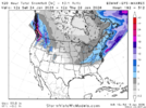
5 day snow mean with 2-6" across NC-VA.
View attachment 184254
Yes
Been the theme all winter.Late Next week just decided to trend colder View attachment 184255
