*quietly* i kind of like the look here, shortwave digs a hair more, trough orientation a little less positive @hr42
I wish I'd say baby steps but this needs to get a roll on if we want better snow. It had less cold air overall on that one.
*quietly* i kind of like the look here, shortwave digs a hair more, trough orientation a little less positive @hr42


Not great looks. Absolutely need a NW trend on something.. If not Euro GEFS.Nasty trend from the Good For Shoot model View attachment 184059
Looks like Weathernext2 I believe. Wow

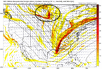
thought it had a chance to reverse with improvements upstream but alas in the end nothing really mattered. makes you think about life.GFS's tilt was more positive this run. View attachment 184061
you crushed this, call last night sticking to the ai's was babe ruth pointing to the stands. we seem to always claw our way back to something somehow so i don't think it's over but this is a bummer. my dream to watch playoff football in my buddy's backyard with snowfall is somehow still aliveNasty trend from the Good For Shoot model View attachment 184059

Need a neutral tilt.. but I'm accepting our fate.Not great looks. Absolutely need a NW trend on something.. If not Euro GEFS.


This one will go into the hall of almost along with a number of others since 2019The really frustrating thing is, we have a ton of cold air around this year. It would be different if all of the cold was over in Russia. But it's not. But the only thing we can get for weeks on end are low IQ clippers or shortwaves that do EVERY SINGLE THING they can to end up with the worst possible outcome. I mean, not even something down the middle of the road or something quasi-mediocre, but just the worst possible outcome.
What if I showed you this banger a week ago and told you it could snow. What would you have said?The really frustrating thing is, we have a ton of cold air around this year. It would be different if all of the cold was over in Russia. But it's not. But the only thing we can get for weeks on end are low IQ clippers or shortwaves that do EVERY SINGLE THING they can to end up with the worst possible outcome. I mean, not even something down the middle of the road or something quasi-mediocre, but just the worst possible outcome.

Need different letters up northWhat if I showed you this banger a week ago and told you it could snow. What would you have said?View attachment 184075

Where I'm at the cold air is actually pretty well placed, but we can't get any runs with moisture.. Praying a NW trend starts occuring here.While I think this is a long shot given this isn’t traditional at all (no true cold source + WAA setup) ... I think the primary key is the shortwave digging into the Dakotas as our trough attempts its best to dig and tilt as much as it can. The farther south and stronger this piece is, the quicker our trough is forced east… ultimately less digging and an even more positively tilted look.
The “good” runs that show a better snow footprint have this feature along or north of the US/Canada border. The latest “meh” runs have it much farther south, putting more pressure on the backside of the trough and kicking it out.
Really a thread-the-needle situation. I find some solace in the fact that these Canadian energy pieces often move around quite a bit, even within the 60-72 hour window, so I think there’s still room for movement (I wouldn’t get my hopes up)… but alas, we track!
This also doesn’t solve the lack of cold air. Even with a perfect dig, still need the perfect balance of precip-driven cooling in marginal temperatures (even worse during daylight hours if you’re in the Carolinas), without so much amplification that you introduce an excessive amount of WAA.
**Attached GIF is of old runs that had better snowfall footprints
Yes, there was a recon mission in the Atlantic and the pacific.Has this disturbance even been sampled yet??


Still way more NW than 36 hours ago
Is that good or bad?Little more east coast ridging on the Euro so far View attachment 184089
Ehhh this looks like a slowdown/slow NW trend