CNCsnwfan1210
Member
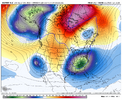
Feel like it’s been forever since we’ve gotten a bomb off of one these H5 looks View attachment 180093View attachment 180094
Looks like Miller A material
Sent from my iPhone using Tapatalk
Feel like it’s been forever since we’ve gotten a bomb off of one these H5 looks View attachment 180093View attachment 180094

Seeing pretty consistently stay in COD mostly on the left side in guidance. I’m beginning to wonder if it ends up like 2013-14 where in went in COD on the left side in December and pretty much stayed there until springYeah , but by then what phase will
Mjo be in. That’s a major player


Too many shortwaves on the west coastGFS is just too flat and no digging with the troughs too far east


euro

I said it days ago when people were can kicking with DT. We are cooking with the right ingredients in that jan 6th-10th time frame. Thats all the heck we can ask for at this range for prime climo. Id sacrifice the first marginal for the 2nd big dog!Yeh we about to cook here. Another one following. About to see what the surface shows. View attachment 180110

Facts! H5 says it all. Models will eventually show something. It's a matter of time and we're in prime climo for everyone.I said it days ago when people were can kicking with DT. We are cooking with the right ingredients in that jan 6th-10th time frame. Thats all the heck we can ask for at this range for prime climo. Id sacrifice the first marginal for the 2nd big dog!
Yeh lot of energy there but just didn't do the thing.


Looks good but need to shift this west some. Don’t want a late bloomer and only New England gets in on the action12z EPS remains solid & even better.View attachment 180113View attachment 180114
Yeh the trough axis is not great at all. I think the period after this will need to be watched also with an active Southern jet.Looks good but need to shift this west some. Don’t want a late bloomer and only New England gets in on the action

I like it, from a fellow Alabama poster! Hopes are high for most of the forum area.aView attachment 180124
It ain’t much but the best eps run of the winter down here this season. Keep it up


Oh boy here we goLooks like the 1/4 to 1/6 period of interest has been moved to 1/6 to 1/10. Delayed but not denied?