I mean just a whiff of downslope flow sends KMRN to the sun on days like this. They might go for 77+
-
Hello, please take a minute to check out our awesome content, contributed by the wonderful members of our community. We hope you'll add your own thoughts and opinions by making a free account!
You are using an out of date browser. It may not display this or other websites correctly.
You should upgrade or use an alternative browser.
You should upgrade or use an alternative browser.
Pattern NC Only Thread
- Thread starter SD
- Start date
Weak front just dunked on temps and dews
DP down to 28, gonna be a surprisingly chilly nightWeak front just dunked on temps and dews
Lol. Christmas mcs
Bah Humbug

Last edited:
Had a hi of 70.2 on Christmas Eve. #winningnotwinning
Webberweather53
Meteorologist
Even the HRRR is having a tough time getting Fayetteville out of the 40s on Fri. 
If only we could hit a 70 on christmas eve on the golf course.Had a hi of 70.2 on Christmas Eve. #winningnotwinning
Cooking this morningLol. Christmas mcsView attachment 179811

Merry Christmas! Me and the wife are cooking this morning. I've got the turkey in the oven and we will have plenty of dressings, sides and dessert to go with it.
Webberweather53
Meteorologist

Webberweather53
Meteorologist
Good luck getting anything close to the NDFD grids to verify Friday afternoon in NC.
Even the HRRR, which over mixes and underestimates CAD can’t get us out of the mid-upper 40s


Even the HRRR, which over mixes and underestimates CAD can’t get us out of the mid-upper 40s
NCHighCountryWX
Member
- Joined
- Dec 28, 2016
- Messages
- 700
- Reaction score
- 1,921
ECMWF and EPS next 10 Days


NCHighCountryWX
Member
- Joined
- Dec 28, 2016
- Messages
- 700
- Reaction score
- 1,921

70-degree Christmas a sign winter is losing its cool
Since 1970, average winter temperatures in the Triangle have increased about 5.6 degrees. The region now experiences roughly 17 more winter days above normal each year compared with the 1970s.
 www.wral.com
Since 1970, average winter temperatures in the Triangle have increased about 5.6 degrees. The region now experiences roughly 17 more winter days above normal each year compared with the 1970s.
Webberweather53
Meteorologist
Good luck getting anything close to the NDFD grids to verify Friday afternoon in NC.
Even the HRRR, which over mixes and underestimates CAD can’t get us out of the mid-upper 40s
View attachment 179834
View attachment 179835
Lol this aged badly

Likely related to the last second north shift with this system over the NE US which ofc is mostly being forced by warm advection.

packfan98
Moderator
Let NYC sweat this one out. It’s definitely no fun to have your backyard lose a big storm to the north or the mix line ruin everything at the last minute.Lol this aged badly
View attachment 179925
Likely related to the last second north shift with this system over the NE US which ofc is mostly being forced by warm advection.
View attachment 179926
Webberweather53
Meteorologist
Let NYC sweat this one out. It’s definitely no fun to have your backyard lose a big storm to the north or the mix line ruin everything at the last minute.
Yeah been there done that it seems like a hundred times over the years. I'd much rather be on this side of the boundary watching my temps go up several or more degrees w/ inconsequential sensible impacts overall, other than just having a slightly nicer day to be outside
Brent
Member
Yeah my met friend near Philly may get screwed lol
Been there done that
Been there done that
Mahomeless
Member
- Joined
- Oct 17, 2023
- Messages
- 900
- Reaction score
- 2,158
This thread….lol
This comment...lolThis thread….lol
Temps still slowly falling this morning. Tomorrow looks like a no win forecast around here.
SimeonNC
Member
This reminds me of that storm that hit NYC/Long Island when my fam and I went up in like March of 2019, I think they were supposed to get eight something inches of snow and it ended up being mainly sleet.Lol this aged badly
View attachment 179925
Likely related to the last second north shift with this system over the NE US which ofc is mostly being forced by warm advection.
View attachment 179926
Headed up the hill to WNC this morning. Cloud ceiling on the escarpment at maybe 2000’ ASL, but I bet it’s higher when you crest the hill in Hendersonville

Brent
Member
This reminds me of that storm that hit NYC/Long Island when my fam and I went up in like March of 2019, I think they were supposed to get eight something inches of snow and it ended up being mainly sleet.
I was there in February 2018 and it was a strange storm... Central Park had about 4 inches. I mean the most beautiful scene you could imagine. A couple miles away in Midtown very little evidence it even snowed haha
The city proper doesn't do well when it's borderline usually
wudge

Last edited:
Southern on the 6's coming soon 
NBAcentel
Member
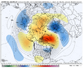
I wouldn’t get to freaked out by the end of the EPS yet, it’s slowly retrograding and headed for a +PNA. What would cause big issues is a overextension that last longer then modeled. That’s probably the fail point. But this looks fine. The PT is slowly backing away, raising heights out west, and you can see a slow migration of the TPV towards Hudson Bay 
trackersacker
Member
Thought the exact same thing. I think it’ll be fineI wouldn’t get to freaked out by the end of the EPS yet, it’s slowly retrograding and headed for a +PNA. What would cause big issues is a overextension that last longer then modeled. That’s probably the fail point. But this looks fine. The PT is slowly backing away, raising heights out west, and you can see a slow migration of the TPV towards Hudson Bay View attachment 179994
I worry this is a look that will look acceptable in a mean but is likely ugly once the spread reduces. Since it's likely a transient pattern it's not that big of a dealI wouldn’t get to freaked out by the end of the EPS yet, it’s slowly retrograding and headed for a +PNA. What would cause big issues is a overextension that last longer then modeled. That’s probably the fail point. But this looks fine. The PT is slowly backing away, raising heights out west, and you can see a slow migration of the TPV towards Hudson Bay View attachment 179994
BrickTamland
Member
Think the 1/4 to 1/6 period might have some legs for some wintry mischief. It's been showing up off and on with the models for a while now.
Spent the day in/around Waynesville where it got up to 65 under increasingly sunny skies. Temp went down 11 degrees between there and KAVL. Got into fog near Saluda at 2000’ ASL and then drove down out of it. Some fun local temp stuff todayHeaded up the hill to WNC this morning. Cloud ceiling on the escarpment at maybe 2000’ ASL, but I bet it’s higher when you crest the hill in Hendersonville
View attachment 179943
JP152
Member
Improving it.What are these other two map blobs surrounding our beautiful state outline?

 I see a front slipping SW through Wake County
50 currently here and with the lone exception on Christmas Eve (71), I've mostly avoided the torch up here
Thought i had a chance to stay on the cool side today lol50 currently here and with the lone exception on Christmas Eve (71), I've mostly avoided the torch up here
 68
68Front just rolled through 74 -> 69 already
trackersacker
Member
49/43 backdoor front cooking