-
Hello, please take a minute to check out our awesome content, contributed by the wonderful members of our community. We hope you'll add your own thoughts and opinions by making a free account!
You are using an out of date browser. It may not display this or other websites correctly.
You should upgrade or use an alternative browser.
You should upgrade or use an alternative browser.
Pattern January Joke
- Thread starter SD
- Start date


Bigedd09
Member
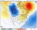
Extended EPS for 1/14/25:
12/22/25 run: ugly -PNA
View attachment 179882
12/25/25 run: much better
View attachment 179883
12/22/25 run: SE 850s slightly AN
View attachment 179889
12/25/25 run: SE 850s slightly BN
View attachment 179890
Great progress!
Sent from my iPhone using Tapatalk
256wx
Member
@GaWx - have we ever historically had a PNA+ and NAO- pairing for any substantial length of time and not had snow in the SE? I’m new to this game, people seem to be extremely optimistic at the possibility across the boards. Definitely sounds like a best case scenario, but nothing is guaranteed, it is indeed the weather. I figured you have some way you research/statistics compilation program where you could search with those stipulations and see prior outcomes. Appreciate all the great posts from everyone here.
@GaWx - have we ever historically had a PNA+ and NAO- pairing for any substantial length of time and not had snow in the SE? I’m new to this game, people seem to be extremely optimistic at the possibility across the boards. Definitely sounds like a best case scenario, but nothing is guaranteed, it is indeed the weather. I figured you have some way you research/statistics compilation program where you could search with those stipulations and see prior outcomes. Appreciate all the great posts from everyone here.
Great question! Snow in the SE can be tough to get in cold/dry patterns or it could be hit and miss/localized instead of widespread even when it’s cold.
And then a question is what counts in your mind? What if much of the SE gets just flurries outside of significant upslope mtn snow? Does that count? Or what if only a small part of the non-mountain SE gets accumulating snow and the rest gets little or nothing. Does that count?
And then I’m pretty sure one can have a +PNA and -NAO and not be cold enough for snow. Or it warms up and then rains.
So, without giving specifics, I’d say the answer is an easy yes unless you’d count flurries in just a part of the SE, which I suspect is not what you mean. But even then, I’d say yes because of its likely there have been some mild +PNA/-NAO periods with no flurries anywhere.
256wx
Member
That’s a good response- I should have been more specific. In general, I would not count flurries. So accumulating snow greater than. .5” is the metric I would use. And when people say SE, most probably have their own locale in mind. Eastern TN, NC, even VA or WV is considered Southeastern to some. I’ll rephrase my question to Deep South. Northern/Central areas of Gulf states. I’m in the Huntsville AL area and have been fortunate in the 3 years I’ve been here to have seen something every winter thus far. I’m a Florida transplant up here and actually having 4 seasons now is what piqued my interest in weather patterns and snow possibilities after living somewhere with boring weather for so long.
I definitely think I understand the blocking patterns and the logistics of how they should help us score snow. Maybe I’m a bit more uncertain as to how often the PNA+ and -NAO occur simultaneously and the implications for this area. It just seems from a cursory reading of the forums like it’s a holy grail/best possible setup which leads me to believe it may be very rare, but that may not be the case. Thanks for all the input!
I definitely think I understand the blocking patterns and the logistics of how they should help us score snow. Maybe I’m a bit more uncertain as to how often the PNA+ and -NAO occur simultaneously and the implications for this area. It just seems from a cursory reading of the forums like it’s a holy grail/best possible setup which leads me to believe it may be very rare, but that may not be the case. Thanks for all the input!
NBAcentel
Member
Typically the +PNA/-NAO events that flunk is one where it’s coupled to a AK vortex/+EPO, which causes a weak cold air source and a ineffective western ridge for digging shortwaves. The best +PNA setups (2014/2015/2018/2022/2025) are ones with a -EPO/+PNA (where the ridge is lined up from the west coast through B.C and Alaska)Great question! Snow in the SE can be tough to get in cold/dry patterns or it could be hit and miss/localized instead of widespread even when it’s cold.
And then a question is what counts in your mind? What if much of the SE gets just flurries outside of significant upslope mtn snow? Does that count? Or what if only a small part of the non-mountain SE gets accumulating snow and the rest gets little or nothing. Does that count?
And then I’m pretty sure one can have a +PNA and -NAO and not be cold enough for snow. Or it warms up and then rains.
So, without giving specifics, I’d say the answer is an easy yes unless you’d count flurries in just a part of the SE, which I suspect is not what you mean. But even then, I’d say yes because of its likely there have been some mild +PNA/-NAO periods with no flurries anywhere.
I’ll do a ex for NC
2014 (significant winter storm in the SE), it wasn’t long lasting, but a ridge bridge out west.


Feb 2015 (big +PNA/-EPO)

Events during the pattern


Jan 2018 (+PNA/-EPO)


I can’t add anymore attachments, but it seems in the last decade, our best winter storms occur when we have a -EPO/+PNA, and the Atlantic side not being the big driver at all. Not saying it isn’t a big driver, and it can definitely result in events, but the -EPO/+PNA pathway is the way to go recently. That’s always why I get excited when I see a WC/AK ridge bridge. Seems like that’s the best way to score recently. We all remember 2022, multiple events in that -EPO/+PNA regime, and 2025 as well even if they weren’t exactly great events for some.
256wx
Member
That’s extremely helpful, I love learning about this stuff. Makes perfect sense. I really appreciate you guys taking the time to educate!Typically the +PNA/-NAO events that flunk is one where it’s coupled to a AK vortex/+EPO, which causes a weak cold air source and a ineffective western ridge for digging shortwaves. The best +PNA setups (2014/2015/2018/2022/2025) are ones with a -EPO/+PNA (where the ridge is lined up from the west coast through B.C and Alaska)
I’ll do a ex for NC
2014 (significant winter storm in the SE), it wasn’t long lasting, but a ridge bridge out west.
View attachment 179893
View attachment 179898View attachment 179899
Feb 2015 (big +PNA/-EPO) View attachment 179894
Events during the pattern View attachment 179895View attachment 179896View attachment 179897
Jan 2018 (+PNA/-EPO) View attachment 179900View attachment 179901View attachment 179902
I can’t add anymore attachments, but it seems in the last decade, our best winter storms occur when we have a -EPO/+PNA, and the Atlantic side not being the big driver at all. Not saying it isn’t a big driver, and it can definitely result in events, but the -EPO/+PNA pathway is the way to go recently. That’s always why I get excited when I see a WC/AK ridge bridge. Seems like that’s the best way to score recently. We all remember 2022, multiple events in that -EPO/+PNA regime, and 2025 as well even if they weren’t exactly great events for some.
BrickTamland
Member
Looks like a nice stretch of cold weather here starting rhe 30th with highs in the 40s for a week at least. Wouldn't be surprised if we get an ice storm chance during that stretch.
NBAcentel
Member
moyock gets theirs no matter what 
NBAcentel
Member
if that upstream ridging keeps getting stronger on modeling around Alaska we might get a colder airmass and longer lasting then the December one 

CNCsnwfan1210
Member
if that upstream ridging keeps getting stronger on modeling around Alaska we might get a colder airmass and longer lasting then the December one View attachment 179904View attachment 179905
That’s one firecracker of a -NAO. Seems like its bullying that TPV
Sent from my iPhone using Tapatalk
That’s extremely helpful, I love learning about this stuff. Makes perfect sense. I really appreciate you guys taking the time to educate!
I forgot to mention that even if all of the indices are lined up favorably like 7s on a slot machine, there’s a strong enough cold air connection, there’s plentiful moisture, and there’s an energetic storm, the exact track of the storm’s surface low still often trumps just about everything else for one’s specific area. That could be the difference in you being in one of the lucky sweet spots and getting a major snow, it being further NW and you getting a quick change to rain, it being even further NW and you getting no snow and instead just rain, or it being too far SE and you getting only light snow or even no precip.
Predicting the exact track is difficult too far in advance.
But you probably already realize all of this.
- Joined
- Jan 23, 2021
- Messages
- 4,603
- Reaction score
- 15,199
- Location
- Lebanon Township, Durham County NC
You love to see people asking great questions and trying to learn@GaWx - have we ever historically had a PNA+ and NAO- pairing for any substantial length of time and not had snow in the SE? I’m new to this game, people seem to be extremely optimistic at the possibility across the boards. Definitely sounds like a best case scenario, but nothing is guaranteed, it is indeed the weather. I figured you have some way you research/statistics compilation program where you could search with those stipulations and see prior outcomes. Appreciate all the great posts from everyone here.

NBAcentel
Member
Another reason I like the pattern in the medium range getting colder is because now the AIGFS shows something wintry with the system looming just under D10 for the first time, it’s not great but it’s a start. The overall synoptic scale pattern doesn’t look great for snow, but if the pattern keeps slowing/gets colder, we can wiggle ourselves into a messy setupThat’s one firecracker of a -NAO. Seems like its bullying that TPV
Sent from my iPhone using Tapatalk


Last edited:
NBAcentel
Member
Same thing occurring on the GFS
Also check out the end of the GFSAI. Beautiful stuff right there
Also check out the end of the GFSAI. Beautiful stuff right there
Same thing occurring on the GFSView attachment 179912
Also check out the end of the GFSAI. Beautiful stuff right there View attachment 179913
That is your big dog pattern for us in the west and central SE.
The end of the UKMET looks intriguing. It drops an expansive Arctic high with cold air draped from the Rockies to the coast, with energy lurking in the SW that looks poised to move eastward as the main trough lifts out. Seeing that second push of cold air following the end of the month cold front is nice.


NBAcentel
Member
Nice trend on the GEFSAI 

LukeBarrette
im north of 90% of people on here so yeah
Meteorology Student
Member
2024 Supporter
2017-2023 Supporter
We need to make sure we don’t get too much of the suppressive cold front like vorticity feature. Seen a lot of runs recently with multiple periods of that long ribbon of vorticity appearance and it will kill anything that gets close to itThe end of the UKMET looks intriguing. It drops an expansive Arctic high with cold air draped from the Rockies to the coast, with energy lurking in the SW that looks poised to move eastward as the main trough lifts out. Seeing that second push of cold air following the end of the month cold front is nice.
View attachment 179914View attachment 179915
As others have mentioned, clearly things should try to get a bit more interesting as we move toward mid-January with Asia finally waking up (+EAMT), the Pac Jet extending, and wave breaking occurring in the E Pacific (-EPO / +PNA) rather than in the W Pacific (-WPO / -PNA) at the jet exit region.
+EAMT and the associated Pac Jet changes look to be driving the bus with the pattern ahead.
Other than the MJO not being camped out in the Maritime Continent, I'm viewing it as a non-factor thus far this winter (not what I expected back in Oct/Nov). You can see on the VP hovmoller (last image) how the enhanced convective signal in the tropics is cycling every 10-20 days going back to mid-Nov (and before that really) - that's not a typical MJO which cycles every 30-60 days....so, I don't think we are getting the typical MJO response here.
Last edited:
trackersacker
Member
EPS looks pretty decent to me in the day 10-12 range

LukeBarrette
im north of 90% of people on here so yeah
Meteorology Student
Member
2024 Supporter
2017-2023 Supporter
STJ ConnectionWell HELLO

There is that timeframe again on the 06z GFS AI


HurricaneSolomon
Member
- Joined
- Dec 6, 2021
- Messages
- 154
- Reaction score
- 276
There is that timeframe again on the 06z GFS AI
View attachment 179933View attachment 179934View attachment 179935View attachment 179936
This seems to be persistent. Well somewhat. It is definitely worth checking.
Sent from my iPad using Tapatalk
CNCsnwfan1210
Member
There is that timeframe again on the 06z GFS AI
View attachment 179933View attachment 179934View attachment 179935View attachment 179936
18z Euro AI last nighthad nearly the same thing around 1/7-1/8 FWIW
Sent from my iPhone using Tapatalk

Bigedd09
Member
12z AIGFS has a pretty solid look on January 5-6.. Surface temps are marginal but a decent look at this range
Bigedd09
Member
And has another storm coming in on the 9th.12z AIGFS has a pretty solid look on January 5-6.. Surface temps are marginal but a decent look at this range
NBAcentel
Member


BrickTamland
Member
The models have been showing something off and on for around Jan 5 and 6. I think the Euro had a big storm around then a while back before dropping it. Sometimes we get that with a model where it shows a big one and then it goes poof only for the models to bring something back down the road for the same time frame.
CNCsnwfan1210
Member

Southward shift of the TPV aided by the -NAO going to work
Sent from my iPhone using Tapatalk
Webberweather53
Meteorologist
As others have mentioned, clearly things should try to get a bit more interesting as we move toward mid-January with Asia finally waking up (+EAMT), the Pac Jet extending, and wave breaking occurring in the E Pacific (-EPO / +PNA) rather than in the W Pacific (-WPO / -PNA) at the jet exit region.
+EAMT and the associated Pac Jet changes look to be driving the bus with the pattern ahead.
Other than the MJO not being camped out in the Maritime Continent, I'm viewing it as a non-factor thus far this winter (not what I expected back in Oct/Nov). You can see on the VP hovmoller (last image) how the enhanced convective signal in the tropics is cycling every 10-20 days going back to mid-Nov (and before that really) - that's not a typical MJO which cycles every 30-60 days....so, I don't think we are getting the typical MJO response here.
View attachment 179921
View attachment 179922
View attachment 179920
Yeah a lot of this is internally driven multi-week mid-latitude variability’s
Honestly, the biggest impacts the MJO is having on our weather going forward are just very slow lagged responses to the previous big event in late November.
Namely, the weakening of the polar vortex with those circulation anomalies finally propagating into the troposphere and the strong +u anomalies that have propagated poleward into the subtropics now (in typical GWO fashion)

We have been doing this for the last couple of months.


It's a start:

Start the thread.

NBAcentel
Member
The GFSAI pumping out fantasy storms/events like the regular GFS does 


Webberweather53
Meteorologist
Hard not to like where we’re at going forward
Yep was gonna say I am a fan of the AI models consistently throwing some LR bones. Get the pattern, get the noise, narrow down to a window, reel it inHard not to like where we’re at going forward