• Hello, please take a minute to check out our awesome content, contributed by the wonderful members of our community. We hope you'll add your own thoughts and opinions by making a free account!

12/8/2025 Event - Repeat of Last Week?

WRAL met Chris Michaels posted this on Facebook an hour ago. But to me it looks like the models are showing more precip and dynamic cooling now, thus more of a chance for a decent snow event here.

Let me explain my thought process behind Monday. I'll start with nuts and bolts and then dig a little deeper, because I think you deserve that transparency.

And I think it's appropriate that a meteorologist talks some meteorology - which I'm seeing less and less of in recent years.

WHAT:
1. Some rain Monday morning with some sleet pellets/snowflakes mixing in later in the morning into the early afternoon hours north of I-40.
2. Any light accumulation would be just that. VERY light toward the Virginia state line and on the grass.
3. Any moisture Monday night/Tuesday morning will freeze as temperatures drop into the upper teens and 20s.

EXPLANATION:

1. First and foremost, it's not like we've got this honkin' system riding up from the Gulf with tons of moisture. The storm is going to have to manufacture its own moisture, which almost never bodes well for snow-lovers in our area.

2. Secondly, morning temperatures start above freezing and then temperatures drop during the day. As that happens, drier air intrudes from the north. So, your cold air and moisture aren't totally in sync.

So, for a few hours, you'll have snowflakes falling from the clouds and likely melting as they get closer to the "warmer" ground.

As the entire air column cools, you may get enough snow well after sunrise Monday to give us that little dusting toward the Virginia state line. Aside from that, it might just be a conversation starter for some folks north of I-40/I-85.
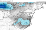
Chris is a good Met. Worked in Roanoke for a number of years. Met him personally at a conference about a month ago. Super nice guy and was cool to meet him since I had talked to him on Twitter for many years.
 
WRAL met Chris Michaels posted this on Facebook an hour ago. But to me it looks like the models are showing more precip and dynamic cooling now, thus more of a chance for a decent snow event here.

Let me explain my thought process behind Monday. I'll start with nuts and bolts and then dig a little deeper, because I think you deserve that transparency.

And I think it's appropriate that a meteorologist talks some meteorology - which I'm seeing less and less of in recent years.

WHAT:
1. Some rain Monday morning with some sleet pellets/snowflakes mixing in later in the morning into the early afternoon hours north of I-40.
2. Any light accumulation would be just that. VERY light toward the Virginia state line and on the grass.
3. Any moisture Monday night/Tuesday morning will freeze as temperatures drop into the upper teens and 20s.

EXPLANATION:

1. First and foremost, it's not like we've got this honkin' system riding up from the Gulf with tons of moisture. The storm is going to have to manufacture its own moisture, which almost never bodes well for snow-lovers in our area.

2. Secondly, morning temperatures start above freezing and then temperatures drop during the day. As that happens, drier air intrudes from the north. So, your cold air and moisture aren't totally in sync.

So, for a few hours, you'll have snowflakes falling from the clouds and likely melting as they get closer to the "warmer" ground.

As the entire air column cools, you may get enough snow well after sunrise Monday to give us that little dusting toward the Virginia state line. Aside from that, it might just be a conversation starter for some folks north of I-40/I-85.
Chris Michaels is relatively new to the area and North Carolina as a meteorologist at WRAL so all I'll say is that he may be in for a surprise come Monday if these model trends keep swinging our way. Greg Fishel got burned when he said that Raleigh would not get an inch of snow when a system like this came our way one time. He was a man of his word and did his next broadcast standing in the fountain at WRAL.
 
Chris Michaels is relatively new to the area and North Carolina as a meteorologist at WRAL so all I'll say is that he may be in for a surprise come Monday if the model trends keep going our way. Greg Fishel got burned one time when he said that Raleigh would not get an inch of snow when a system like this came our way one time. He was a man of his word and did his next broadcast standing in the fountain at WRAL.
wait was that the 2000 blizzard of 18+ inches across the Triangle when they'd called for an inch or two? or was this a later one you're referring to?
 
Looks like we are about two more positive ticks away from a solid event for a relatively large area. Dig the energy a little more sets everything in good direction. Some models have been getting a coastal system cranking quickly enough to get eastern areas in the game too. Usually something will start trending the wrong direction for us, but there’s not too much time left for huge changes. Fun times!
 
Looks like we are about two more positive ticks away from a solid event for a relatively large area. Dig the energy a little more sets everything in good direction. Some models have been getting a coastal system cranking quickly enough to get eastern areas in the game too. Usually something will start trending the wrong direction for us, but there’s not too much time left for huge changes. Fun times!
Has potential for a late blooming coastal for sure. I'll feel better about it if trends don't go the wrong direction tomorrow. I've seen a lot of decent snow maps from ops and ensembles over last couple yrs that failed miserably.
 
wait was that the 2000 blizzard of 18+ inches across the Triangle when they'd called for an inch or two? or was this a later one you're referring to?
This was a later storm I was referring to. He said that he would stand in the WRAL fountain one evening and make his next broadcast if Raleigh got an inch of snow from a clipper type system that was approaching. I forgot about the one to two inch forecast before the big one in 2000.
 
This is still a ongoing trend on the hrrr, even compared to the 18z run, is has been slowing/digging further SW more, in a setup like this where a small change makes a massive difference, this is massive, if this ongoing trend continues, it’s gonna reflect massively towards go time IMG_0455.gif
 
I was going through the CIPS analogs, and the first match was January 9th, 2004. I pulled up the ERA5 Reanalysis maps, and there are a LOT of similarities.
gfs-deterministic-conus-vort500_z500-5227600.pngus_reanalyse-en_modera5_200401091800_5_457.pnggfs-deterministic-conus-z300_speed-5195200.pngus_reanalyse-en_modera5_200401091800_5_449.png

1. Both have positively tilted, mostly open waves over the TN Valley with a closed low back over the Upper Midwest/Great Lakes. In the January 2004 case, the western ridge was a little stronger and displaced farther north; thus, the trough digs deeper and is a touch more amplified. I'd expect the Monday setup to have less QPF than 2004, unless the wave deepens. (trend has been good)

2. Both events have a strong jet core from the Southeast up the East Coast, with NC in the favored entrance region of that jet. In both setups, upper-level divergence from that jet circulation is the primary ascent mechanism for NC. January 2004 looks like it has slightly cleaner coupling between the polar and subtropical jet, so less ascent and QPF likely on Monday.

That storm dropped a good 2-3 inches across NC. Really, I see this as our high-end potential if we can just get the wave to dig a little deeper. The trend is looking good.
january_9_2004_nc_snowmap.gif
 
Last edited:
WRAL met Chris Michaels posted this on Facebook an hour ago. But to me it looks like the models are showing more precip and dynamic cooling now, thus more of a chance for a decent snow event here.

Let me explain my thought process behind Monday. I'll start with nuts and bolts and then dig a little deeper, because I think you deserve that transparency.

And I think it's appropriate that a meteorologist talks some meteorology - which I'm seeing less and less of in recent years.

WHAT:
1. Some rain Monday morning with some sleet pellets/snowflakes mixing in later in the morning into the early afternoon hours north of I-40.
2. Any light accumulation would be just that. VERY light toward the Virginia state line and on the grass.
3. Any moisture Monday night/Tuesday morning will freeze as temperatures drop into the upper teens and 20s.

EXPLANATION:

1. First and foremost, it's not like we've got this honkin' system riding up from the Gulf with tons of moisture. The storm is going to have to manufacture its own moisture, which almost never bodes well for snow-lovers in our area.

2. Secondly, morning temperatures start above freezing and then temperatures drop during the day. As that happens, drier air intrudes from the north. So, your cold air and moisture aren't totally in sync.

So, for a few hours, you'll have snowflakes falling from the clouds and likely melting as they get closer to the "warmer" ground.

As the entire air column cools, you may get enough snow well after sunrise Monday to give us that little dusting toward the Virginia state line. Aside from that, it might just be a conversation starter for some folks north of I-40/I-85.
I agree with everything except for the part about “manufacturing its own moisture”. Not that I expect a big storm out of this, but a ton of good storms in central and eastern N.C. “manufactured their own moisture” like Jan 2000 and Dec 2010.
 
This was a later storm I was referring to. He said that he would stand in the WRAL fountain one evening and make his next broadcast if Raleigh got an inch of snow from a clipper type system that was approaching. I forgot about the one to two inch forecast before the big one in 2000.

Here is the video it was in 2011 it looks like.


Sent from my iPhone using Tapatalk
 
I was going through the CIPS analogs, and the first match was January 9th, 2004. I pulled up the ERA5 Reanalysis maps, and there are a LOT of similarities.
View attachment 178262View attachment 178264View attachment 178263View attachment 178261

1. Both have positively tilted, mostly open waves over the TN Valley with a closed low back over the Upper Midwest/Great Lakes. In the January 2004 case, the western ridge was a little stronger and displaced farther north; thus, the trough digs deeper and is a touch more amplified. I'd expect the Monday setup to have less QPF than 2004, unless the wave deepens. (trend has been good)

2. Both events have a strong jet core from the Southeast up the East Coast, with NC in the favored entrance region of that jet. In both setups, upper-level divergence from that jet circulation is the primary ascent mechanism for NC. January 2004 looks like it has slightly cleaner coupling between the polar and subtropical jet, so less ascent and QPF likely on Monday.

That storm dropped a good 2-3 inches across NC. Really, I see this as our high-end potential if we can just get the wave to dig a little deeper. The trend is looking good.
View attachment 178267
Im sure the CLT metro people remember what occurred 45 days after that. Feb 2004 .... The Southern Piedmont Slammer
 
If we trust the NAM, and that is sometimes asking a lot, then there is reason to be a little optimistic. It usually does well with thermals, and 925s and 850s are fine. Dews are not great until you get to and north of the NC/VA line. But they're good enough to bring temps down, IF the precip is robust enough. Surface temps are AOA freezing in NC where the precip is falling, which will likely keep this from being an impactful event.

The temps do look better than modeled a couple of days ago. But QPF has to be there. I'm always skeptical of these trends that show more and more QPF 24-48 hours out only to snap back and we end up with spotty, broken precip, waiting all day for surface temps to fall out of the upper 30s.

Bigger picture, a 1031 HP is moving in just ahead of the system. You can see the kinks in the isobars east of the Apps. And there's snow cover up there, which helps.

Anyway, I don't trust the NAM QPF or the long range HRRRR at all. But other models are trending, so it's not wrong to think we could make something out of this. It's still not anywhere close to a layup yet.

nam-nest-nc-t850-5213200.png
nam-nest-nc-t925-5213200.png
nam-nest-nc-dew2m_f-5213200.png
nam-nest-nc-t2m_f-5213200.png
nam3km_mslp_pcpn_frzn_seus_47.png
nam3km_mslp_pcpn_frzn_us_42.png
 
If we trust the NAM, and that is sometimes asking a lot, then there is reason to be a little optimistic. It usually does well with thermals, and 925s and 850s are fine. Dews are not great until you get to and north of the NC/VA line. But they're good enough to bring temps down, IF the precip is robust enough. Surface temps are AOA freezing in NC where the precip is falling, which will likely keep this from being an impactful event.

The temps do look better than modeled a couple of days ago. But QPF has to be there. I'm always skeptical of these trends that show more and more QPF 24-48 hours out only to snap back and we end up with spotty, broken precip, waiting all day for surface temps to fall out of the upper 30s.

Bigger picture, a 1031 HP is moving in just ahead of the system. You can see the kinks in the isobars east of the Apps. And there's snow cover up there, which helps.

Anyway, I don't trust the NAM QPF or the long range HRRRR at all. But other models are trending, so it's not wrong to think we could make something out of this. It's still not anywhere close to a layup yet.

View attachment 178274
View attachment 178275
View attachment 178276
View attachment 178277
View attachment 178278
View attachment 178279
It is easier to have hope with the NAM when all the other models have been trending better today, too.
 
This is still a ongoing trend on the hrrr, even compared to the 18z run, is has been slowing/digging further SW more, in a setup like this where a small change makes a massive difference, this is massive, if this ongoing trend continues, it’s gonna reflect massively towards go time View attachment 178271
Watching the 0Z HRRR roll in and it’s even more prevalent.
 
Looks like the pna ridge is spiking taller allowing for more digging/the angle of the energy is more north to south which will definitely increase QPF. If the trend continues somebody will get a decent event out of this


Sent from my iPhone using Tapatalk
 
00z nam is digging more in Texas

fddf375f5bc5276ea7d65ad1d8fc848d.gif


Sent from my iPhone using Tapatalk
 
Back
Top