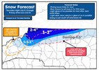
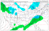
alright well i am a strong believer in forecasting transparency / public humiliation as motivation for getting things right next time, so here's my absolute stinker of a forecast map i made yesterday. just too aggressive, should have looked at QPF more & kuchera less and followed my gut on mixing cutting into totals more, but alas.
recap: some of the northwestern fringe (alleghany, surry counties, just north of mt. airy) of the 1-2" verified. most of Ashe/alleghany was in 2-4" and that was too high, i've seen one 2" report from the very tippy top nw corner of ashe this morning, so technically yay i guess. the 0.5-1" and dusting-0.5" placement was -ok- in WNC, but still too high generally as it seems accumulations above a half inch or so stop around boone. would have been a better map if i had trimmed the 1-2" further northwest (especially on the eastern end of the 1-2" zone) and dropped the 2-4" entirely. also, badly done for most of wilkes co. i think northern wilkes scraped out an inch, but that's all. 0.5 or less in town.
in my defense, i just got my degree 7 months ago and haven't been an operational forecaster for long, and the trends were late in the game on short-range modeling. but that's not really any excuse because my job as a meteorologist isn't to just blend what the models are saying at any given moment, its to predict where they end up
grade: D, maybe D+ if i am being generous. not terribly off in the NW corner of the state, but badly done in the foothills and north central part of the state. at least it looks nice.
View attachment 178082


