-
Hello, please take a minute to check out our awesome content, contributed by the wonderful members of our community. We hope you'll add your own thoughts and opinions by making a free account!
You are using an out of date browser. It may not display this or other websites correctly.
You should upgrade or use an alternative browser.
You should upgrade or use an alternative browser.
Pattern December Doldrums 2025 🎄 ❄️
- Thread starter SD
- Start date
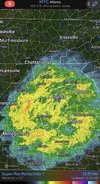
This was back on 11/10What the heck is this a joke or something?

157K views · 1.1K reactions | Holy cow, it is really coming down in Monore. #snOMG #ncwx | Brad Panovich Meteorologist
Holy cow, it is really coming down in Monore. #snOMG #ncwxwww.facebook.com
Sent from my iPhone using Tapatalk
lol, A friend sent it to me, I told him I didn't believe it..... I didn't notice the date.This was back on 11/10
kennedybb6
Member
My phone is saying sleet for the next hour in Waxhaw but I don’t see itlol, A friend sent it to me, I told him I didn't believe it..... I didn't notice the date.
Bigedd09
Member
Really thought we had something brewing on Friday with the euro yesterday. I guess the euro is no longer the king in the medium range lol
Sent from my iPhone using Tapatalk
Sent from my iPhone using Tapatalk
Bigedd09
Member
6z Euro Ai is downright ugly after December 8th if you like cold and snow
Sent from my iPhone using Tapatalk
Sent from my iPhone using Tapatalk
You are dealing with max 2/10ths -3/10ths qpf. Still consistent imo, 50-70 mile shift North or South should be expected from 4 days out with thermal profiles/ BL etc.Really thought we had something brewing on Friday with the euro yesterday. I guess the euro is no longer the king in the medium range lol
Sent from my iPhone using Tapatalk

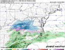
Unfortunately, we encounter the same every year. The models are not going to be able to resolve the nuances that can move the r/s line 50-100 miles or understand where the r/zr line sets up 5 days out. The atmosphere is too complex. From a forecasting standpoint, see if the pattern supports an event and then just use the guidance as guidance until about 3 days, particularly in marginal setups like this, knowing that things are going to bounce around for a while. Then hone in on the details. I'd still be surprised if we end up with a widespread advisory level or higher winter storm. But there are certainly ways it can happen. It's just not easy, as you can see from the precip/lack of precip, cold enough/not cold enough bouncing around. This one is particularly challenging in that we are on a knife's edge getting enough cold air without killing the precip and getting enough precip while maintaining enough cold air.....if you're looking for a major winter storm, that is.Really thought we had something brewing on Friday with the euro yesterday. I guess the euro is no longer the king in the medium range lol
Sent from my iPhone using Tapatalk
This always was and continues to be a souped up novelty event at best. Marginal opportunity with a not ideal caa feed or moisture imo.
Shaggy
Member
Right where we want it. Or something like that.6z Euro Ai is downright ugly after December 8th if you like cold and snow
Sent from my iPhone using Tapatalk
Bigedd09
Member
Right where we want it. Or something like that.
Hoping something can happen December 8-9. 6z GEFS had some noise
Sent from my iPhone using Tapatalk
Webberweather53
Meteorologist
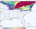
6z EPS 0.1” QPF (or ~0.03” ice accrual based on standard ice liquid ratios) ZR probabilities for Fri
Despite a few op euro runs that got some folks hopes up, I’ve always felt that freezing rain would be the big story with this system. Takes very little of that to cause problems around here, esp when it falls in/around the morning commute
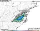
Despite a few op euro runs that got some folks hopes up, I’ve always felt that freezing rain would be the big story with this system. Takes very little of that to cause problems around here, esp when it falls in/around the morning commute

wrapped up my morning forecast. i mean, i have seen worse for our northern foothills friends, who will stand the best chance of getting an early season glance at winter, as always. just gonna be light and messy if anything. no surprises there
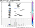

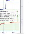
seeing some more long range noise as well this morning on ensembles, as you can see on that wilkes snowgram. i still have some interest for mountain clipper action sunday night into monday as well


seeing some more long range noise as well this morning on ensembles, as you can see on that wilkes snowgram. i still have some interest for mountain clipper action sunday night into monday as well
Yeah I actually got a light dusting that eveninglol, A friend sent it to me, I told him I didn't believe it..... I didn't notice the date.
You tired frost get some sleep. Long winter a head lolI know it's just raining here. but you stare at that camera, you can see flakes flying. me thinks? lol AI snow I guess...
Just a FYI - I got 33 rain. Who would've thunk it?
- Joined
- Jan 23, 2021
- Messages
- 4,595
- Reaction score
- 15,183
- Location
- Lebanon Township, Durham County NC
LukeBarrette
im north of 90% of people on here so yeah
Meteorology Student
Member
2024 Supporter
2017-2023 Supporter
Co worker lives in stokes county, said he had some brief sleet at onset, fyi. But yeah this is some cold water falling out of the sky no doubt.Just a FYI - I got 33 rain. Who would've thunk it?
Nomanslandva
Member
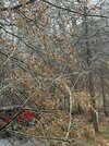
Tree ice up here but not on anything else. 32/32
Nomanslandva
Member
You didn't have any Sunday AM? I had a little sleet and ice on my truck Sunday am.View attachment 177688
First icing event of the season. Probably first of 4-5 for this region
36 and rain here
3 months ago i was playing golf after work
and supposedly this is the season we're waiting for?
3 months ago i was playing golf after work
and supposedly this is the season we're waiting for?
LukeBarrette
im north of 90% of people on here so yeah
Meteorology Student
Member
2024 Supporter
2017-2023 Supporter
I wasn’t in Roanoke, I was in Waynesboro, VA and had some sleetYou didn't have any Sunday AM? I had a little sleet and ice on my truck Sunday am.
Brent
Member
36 and rain here
3 months ago i was playing golf after work
and supposedly this is the season we're waiting for?
Isn't it great
There were places here near 90 2 weeks ago! And I did see 10 minutes of legit snowflakes at 5pm yesterday. Kind of crazy to think about
Drizzle Snizzle
Member
You have to go all the way back to September 2nd when you were playing golf after work ? Must have been a cold fall there.36 and rain here
3 months ago i was playing golf after work
and supposedly this is the season we're waiting for?
Noles1812
Member
Golf is a warm season sport. If i have to wear pants its too cold.You have to go all the way back to September 2nd when you were playing golf after work ? Must have been a cold fall there.
LukeBarrette
im north of 90% of people on here so yeah
Meteorology Student
Member
2024 Supporter
2017-2023 Supporter
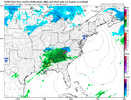
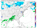
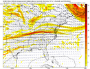
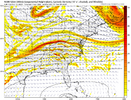
NAM coming in more amped already at hour 60, unflattening the wave.
Met1985
Member
33 and rain this morning. That's fine with me. Looks like ill have my chances with some NW flow snow with several systems.
LukeBarrette
im north of 90% of people on here so yeah
Meteorology Student
Member
2024 Supporter
2017-2023 Supporter
Blue_Ridge_Escarpment
Member
NAM bringing back some life to the Friday event
LukeBarrette
im north of 90% of people on here so yeah
Meteorology Student
Member
2024 Supporter
2017-2023 Supporter
Bigedd09
Member
NAM makes a lot of sense to me. Cold rain for piedmont and ice/snow potential north of I-40
Good 'ol NW trend is back and bringing the coldest of rains with it. Awww it's good to be back to normal 
BrickTamland
Member
Today's weather is awful. Like I always say, give me snow in winter or sunny and warm. Cold rain and cold and dry is just a waste.
Meanwhile, the models are doing their back and forth dance with any type of winter weather here. I guess that's better than not showing any chance at all.
Meanwhile, the models are doing their back and forth dance with any type of winter weather here. I guess that's better than not showing any chance at all.
Last edited:
by mid sep the limiting factor isn't temperature, its daylightYou have to go all the way back to September 2nd when you were playing golf after work ? Must have been a cold fall there.
packfan98
Moderator

