I haven't watched it, but i bet he's going straight Nina. Probably below average snow for the SE. Is that right?
-
Hello, please take a minute to check out our awesome content, contributed by the wonderful members of our community. We hope you'll add your own thoughts and opinions by making a free account!
You are using an out of date browser. It may not display this or other websites correctly.
You should upgrade or use an alternative browser.
You should upgrade or use an alternative browser.
Wintry Winter 25-26 Winter Battle Zone
- Thread starter SD
- Start date
NBAcentel
Member
that’s a fantastic look showing up early dec. Checking a lot of boxes here if you want a early season winter storm 

All signs point to us being in good shape with the push into the Western Hemisphere IMO (Phase 7-8-1). There's a nice removal of the uplift / convective signal in the Maritime Continent (green neg VP) showing up here on the Euro Wk from mid-Nov into early DecGriteater, will the mjo wave have to be strong enough to make it to the colder phases in your opinion?

Is it fair to say that if the amplitude is higher though the various locations that it takes longer to make the orbit? Like, in this case, if we see a higher amplitude wave, is it possible we remain in favorable phases through Christmas, rather than heading into P3+ by Christmas if is a lower amplitude? I would assume a higher amplitude usually takes longer, but maybe it moves faster, so in the end it may not matter. That's probably a really dumb post, but I'm not that smart, so we'll just have to live with it.Over the past 12 days, the trend on the forecast of the Euro Monthly ensemble members has been for an increasing amplitude of the MJO wave as it pushes into Phase 7 (green dots)
View attachment 176401

What I am really trying to say is I want it in the good phases around Christmas so it will snow on my house and be cold around the holidays and I dont care about anything else. TIA!
I think larger amplitude resulting in slower movement sounds logical and believe I've heard that correlation before, but not sure of it. Maybe Webb or others can help with that....but Webb has mentioned that Ninas are known for slower moving MJO waves. Ninos more easily carry the signal east out of the Maritime Continent whereas there are typically westward propagating waves during La Ninas (more common to have easterly low-level winds along the equator in the Pacific) that can slow the MJO's eastward progression. In my mind, we have an ideal scenario at the moment of the MJO wave being slowed down along the way thru 5 and 6, and not racing thru 7 at the moment in the forecasts. We need the slow down so that it's not racing thru the good phases in early Dec. The slower the better of course thru 7-8-1-2Is it fair to say that if the amplitude is higher though the various locations that it takes longer to make the orbit? Like, in this case, if we see a higher amplitude wave, is it possible we remain in favorable phases through Christmas, rather than heading into P3+ by Christmas if is a lower amplitude? I would assume a higher amplitude usually takes longer, but maybe it moves faster, so in the end it may not matter. That's probably a really dumb post, but I'm not that smart, so we'll just have to live with it.
What I am really trying to say is I want it in the good phases around Christmas so it will snow on my house and be cold around the holidays and I dont care about anything else. TIA!

Last edited:
I think larger amplitude resulting in slower movement sounds logical and believe I've heard that correlation before, but not sure of it. Maybe Webb or others can help with that....but Webb has mentioned that Ninas are known for slower moving MJO waves. Ninos more easily carry the signal east out of the Maritime Continent whereas there are typically westward propagating waves during La Ninas (more common to have west low-level winds along the equator in the Pacific) that can slow the MJO's eastward progression. In my mind, we have an ideal scenario at the moment of the MJO wave being slowed down along the way thru 5 and 6, and not racing thru 7 at the moment in the forecasts. We need the slow down so that it's not racing thru the good phases in early Dec. The slower the better of course thru 7-8-1-2
View attachment 176416
Thank you. Always appreciate your insights!

The last SSW event happened in 1958* (rather than '68 as the post says) but it is to be noted that this event yielded large amounts of snow across NC and SC just a week and a half later on December 11.
Raleigh got 9 inches, and areas of Nash County NC got nearly 20 inches. Columbia saw 8.8 inches as well.
This should be fun to track if all goes to plan.
Actually both 1968 and 1958 had a late Nov SSWE:
Oh wow! I stand corrected lol.Actually both 1968 and 1958 had a late Nov SSWE:
Webberweather53
Meteorologist
That’s the last time Fayetteville has seen a foot of snow in a single storm, insane it’s been that long.
My grandfather who passed away a little over month ago told me about this storm when he was stationed in Fort Bragg for basic training. He said he has not seen that much snow in Fayetteville since then (& he would be right
 ).
).What a time it must have beenThat’s the last time Fayetteville has seen a foot of snow in a single storm, insane it’s been that long.
My grandfather who passed away a little over month ago told me about this storm when he was stationed in Fort Bragg for basic training. He said he has not seen that much snow in Fayetteville since then (& he would be right
 . Reading some stories from that event right now. It really makes one hope for this winter.
And I'm sorry for you loss, that is never fun. I hope your grandfather got his fair share of snow over the years.
Is it fair to say that if the amplitude is higher though the various locations that it takes longer to make the orbit? Like, in this case, if we see a higher amplitude wave, is it possible we remain in favorable phases through Christmas, rather than heading into P3+ by Christmas if is a lower amplitude? I would assume a higher amplitude usually takes longer, but maybe it moves faster, so in the end it may not matter. That's probably a really dumb post, but I'm not that smart, so we'll just have to live with it.
What I am really trying to say is I want it in the good phases around Christmas so it will snow on my house and be cold around the holidays and I dont care about anything else. TIA!


If I remember well, it snowed overnight two nights before Thanskgiving in ATL in 2013. We had Janurary 28th snow storm and then the Feb snow/sleet/ice storm in Feb 14. It was a very active winter. Atlanta saw flurries today. This might be a copy of the '13-'14 winter.
J1C1111
Member
You remembered right. I'm hoping for a repeat of 2013-14 as well. Definitely a huge win for us getting snow this early in November and 2013-14 was a great winter compared to recent winters.If I remember well, it snowed overnight two nights before Thanskgiving in ATL in 2013. We had Janurary 28th snow storm and then the Feb snow/sleet/ice storm in Feb 14. It was a very active winter. Atlanta saw flurries today. This might be a copy of the '13-'14 winter.
Also, the 2010-2011... it snowed Christmas day 2010, and we had convective snow the nexf day (26th). January (either 8-11th, one of them days), 2011 is snowed turning into sleet on top. In fact, it snowed the next day I believe because a upper low level swing through. I think it snowed alittle in Feb of that year too! I think a dusting in ATLYou remembered right. I'm hoping for a repeat of 2013-14 as well. Definitely a huge win for us getting snow this early in November and 2013-14 was a great winter compared to recent winters.
NBAcentel
Member
Bigedd09
Member
0Z CFS had a fantasy storm December 8-9... Flashbacks from 2018! Let's ride
GeorgiaGirl
Member
27 today! Thing that I wonder is if today/tomorrow will be enough to stave off the bugs since it's supposed to stay consistently above average for a stretch.
I will say though that we did already have our January 2014 esque month earlier this year.
I will say though that we did already have our January 2014 esque month earlier this year.
- Joined
- Jan 23, 2021
- Messages
- 4,604
- Reaction score
- 15,203
- Location
- Lebanon Township, Durham County NC
Sure there are some dud winters on the list but some of the star appearances in the last ten novembers that saw measurable snow in Charlotte:
2018-2019
2013-2014
1987-1988
1983-1984
1976-1977(coldest january in Charlotte history)
2018-2019
2013-2014
1987-1988
1983-1984
1976-1977(coldest january in Charlotte history)
This is a fantastic write up. The smarter people have spoken about this.
 www.severe-weather.eu
Polar Vortex Watch: A Stratospheric Warming event is about to start, with Cold Weather and Snow to follow behind
A Stratospheric Warming event will disrupt the Polar Vortex, bringing cold weather and snow into the United States, Canada in December
www.severe-weather.eu
Definitely well done. Explained things in a way where most could understand.This is a fantastic write up. The smarter people have spoken about this.
Polar Vortex Watch: A Stratospheric Warming event is about to start, with Cold Weather and Snow to follow behind
A Stratospheric Warming event will disrupt the Polar Vortex, bringing cold weather and snow into the United States, Canada in December
Webberweather53
Meteorologist
Here comes the -EPO


Webberweather53
Meteorologist
Quietly, while La Niña continues to persist, the tropical upper troposphere is rapidly becoming very El Niño-like in response to the West Pac MJO orbit & consecutive bouts of +EAMT fluxing westerly momentum equatorward.

This equatorward shift in the Pacific Jet Stream afforded by the MJO is also pretty key to kicking off the -EPO that shows up near the end of November & is consistent with the findings of Winters et al (2019)

This equatorward shift in the Pacific Jet Stream afforded by the MJO is also pretty key to kicking off the -EPO that shows up near the end of November & is consistent with the findings of Winters et al (2019)
Webberweather53
Meteorologist
Here's the last 90 days worth of mountain torque and updated atmospheric angular momentum (AAM) anomalies.
Notice the near-continuous bouts of positive E Asia Mountain Torque since the middle of October (red line top image) while global atmospheric angular momentum has become positive (black line bottom image).
The MJO provides the westerly momentum in the form of irrotational outflow anomalies, while E Asia Mountain Torque (via successive cold highs descending down into China) effectively "squeezes" & focuses this westerly momentum in the tropics. Hence, the big increase in westerly wind anomalies in the tropics as shown earlier.
Even if the MJO doesn't reach the Western Hemisphere (it almost certainly will), this is just another reason why I've been skeptical of a -PNA in early December, because the global tropics have been legitimately becoming more El Niño like here, which inherently favors a more extended Pacific Jet & +PNA.
BHS1975
Member
Is that good or bad?Here's the last 90 days worth of mountain torque and updated atmospheric angular momentum (AAM) anomalies.
Notice the near-continuous bouts of positive E Asia Mountain Torque since the middle of October (red line top image) while global atmospheric angular momentum has become positive (black line bottom image).
The MJO provides the westerly momentum in the form of irrotational outflow anomalies, while E Asia Mountain Torque (via successive cold highs descending down into China) effectively "squeezes" & focuses this westerly momentum in the tropics. Hence, the big increase in westerly wind anomalies in the tropics as shown earlier.
Even if the MJO doesn't reach the Western Hemisphere (it almost certainly will), this is just another reason why I've been skeptical of a -PNA in early December, because the global tropics have been legitimately becoming more El Niño like here, which inherently favors a more extended Pacific Jet & +PNA.
View attachment 176468
View attachment 176469
Webberweather53
Meteorologist
Is that good or bad?
This favors a heavier +PNA lean in a mean sense as we enter December.
Webberweather53
Meteorologist
Tsappfrog20
Member
Is that good or bad?
It would be a good thing for us!!
Sent from my iPhone using Tapatalk
Today’s Euro Weeklies for Dec 1-21 are still showing consistent strong cold largely avoiding the SE due to a neutral PNA to -PNA not driving the coldest anomalies far into the SE. The Midwest to N Rockies are where the coldest anomalies remain concentrated.
I am okay with that because that will change tomorrowToday’s Euro Weeklies for Dec 1-21 are still showing consistent strong cold largely avoiding the SE due to a neutral PNA to -PNA not driving the coldest anomalies far into the SE. The Midwest to N Rockies are where the coldest anomalies remain concentrated.
I am okay with thar because that will change tomorrow
Even if this verified, NN isn’t mild! But the maps for Dec 1-21 continue to not have a persistent +PNA as it looks on average neutral to -PNA. With that, it’s harder to get all that cold in the SE, especially deeper SE. But yes, the maps always change for better or for worse!
Last edited:
In all seriousness, it’s a step down process! We are getting warnings shots of cold here finally, but no staying power! Highs Sunday were in the 20s and by this Friday and Saturday, will be right at 70.Today’s Euro Weeklies for Dec 1-21 are still showing consistent strong cold largely avoiding the SE due to a neutral PNA to -PNA not driving the coldest anomalies far into the SE. The Midwest to N Rockies are where the coldest anomalies remain concentrated.
I think we start building a good snowpack up here by end of next week and roll it into December!
Webberweather53
Meteorologist
The global tropics zonal wind anomalies this year are evolving very similarly to late 1981, which of course preceded a “Super” El Niño event later in 1982.
Note how this year & 1981 have a big & slow westerly wind burst over the Indian Ocean & Maritime Continent in Oct-Nov (warm colors) that then moved into the Pacific in Dec.


Note how this year & 1981 have a big & slow westerly wind burst over the Indian Ocean & Maritime Continent in Oct-Nov (warm colors) that then moved into the Pacific in Dec.
Webberweather53
Meteorologist
Even if this verified, NN isn’t mild! But the maps for Dec 1-21 continue to not have a persistent +PNA as it looks on average neutral to -PNA. With that, it’s harder to get all that cold in the SE, especially deeper SE. But yes, the maps always change for better or for worse!
I suspect the EPS may be leaning the trough and the surface air mass a bit too hard into the Rockies, as it often likes to do in the extended.
A below average December would certainly be nice here in the Desert SW, but I'm very skeptical of that happening this year.

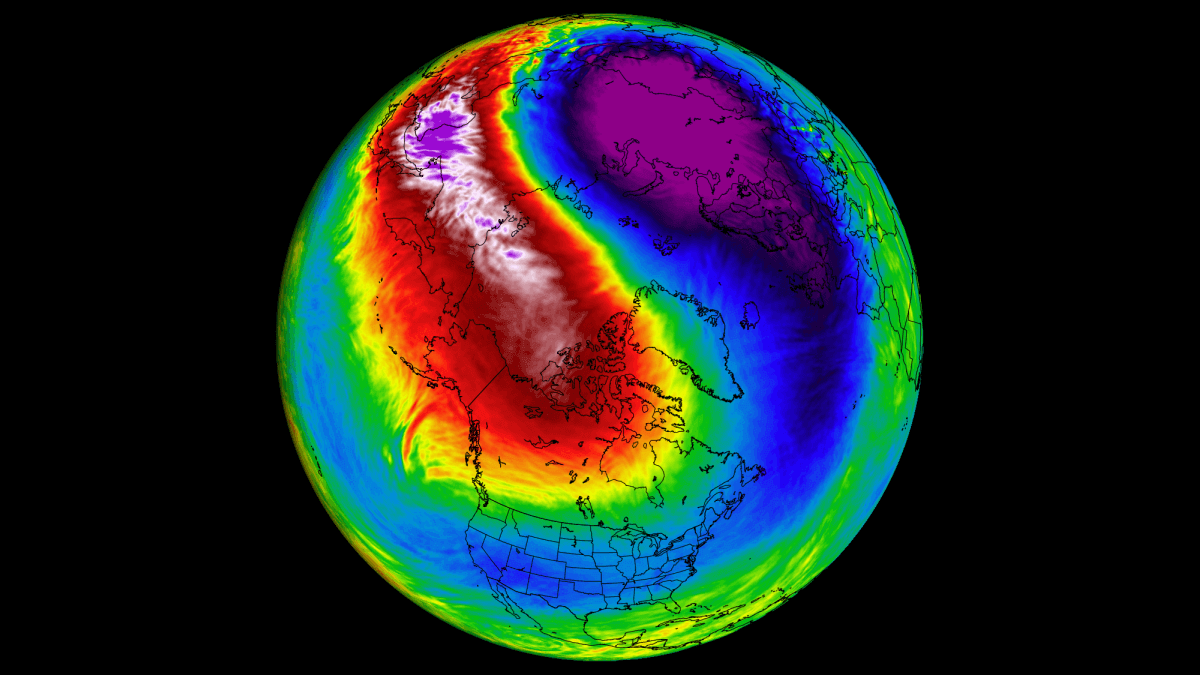
This is what cool ENSO (cool neutral or Nina) with a -NAO & -EPO gets you in December btw:
It's usually hard to get a western trough to stick in this type of pattern in early winter.


Allan Huffman going with a cold January in the E US and a NN overall DJF in the SE: I wonder if this is because of a prog for a very early SSWE followed by a lagged cold effect in Jan:

I’d be quite content with this. Not having a warmer than normal La Niña winter in the majority of the SE including another cold Jan would be a victory!
I’d be quite content with this. Not having a warmer than normal La Niña winter in the majority of the SE including another cold Jan would be a victory!
Last edited:
MRKEVIN7575
Member
I don't want to see the pna too positive or see it too negative. That's why it's very difficult to get winter weather in the southAllan Huffman going with a cold January in the E US and a NN overall DJF in the SE: I wonder if this is because of a prog for a very early SSWE followed by a lagged cold effect in Jan:
View attachment 176485
I’d be quite content with this. Not having a warmer than normal La Niña winter in the majority of the SE including another cold Jan would be a victory!
Webberweather53
Meteorologist
Allan Huffman going with a cold January in the E US and a NN overall DJF in the SE: I wonder if this is because of a prog for a very early SSWE followed by a lagged cold effect in Jan:
View attachment 176485
I’d be quite content with this. Not having a warmer than normal La Niña winter in the majority of the SE including another cold Jan would be a victory!
January is a tough one, possibly the hardest month of this winter to forecast. Subseasonal forcing doesn’t favor +PNA in January, but the westerly momentum build-up in the tropics we’ve created with this MJO passage likely isn’t going away anytime soon and will probably have something to say about that.
The surface impacts from this SSW case look much more immediate than usual, but I do agree that the stratospheric warming event will certainly matter more pattern-wise later in Dec and into Jan as the initial wave driving from the tropics that forced the initial -NAO abates and we rely more on “internally” forced extratropical variability.
I can see this January having a heavy dose of +TNH with the -NAO trying to cling on. My guess is the NAO probably flips to positive for good this winter the next time the MJO orbits into the West-Central Pacific and that happens sometime around late January.
tennessee storm
Member
Better get her done late December or early toI don't want to see the pna too positive or see it too negative. That's why it's very difficult to get winter weather in the south
Mid January , because late January winter is done afraid