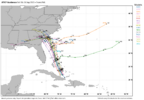
things tracks over sav and into southern ga absolutely hammering rain\
worst case scenario irt rainfall
worst case scenario irt rainfall

I hope you’re right. WNC can not handle anything close to what is being shown right now.I feel like EVERY time we have a tropical system threatening the east coast, things trend north and east as the event draws closer. Of course, the steering for this particular system has many variables.
Not this time. If anything it will be more west.I feel like EVERY time we have a tropical system threatening the east coast, things trend north and east as the event draws closer. Of course, the steering for this particular system has many variables.
Not this time. If anything it will be more west.
The upper low over the south is appearing strong enough to be the main driver of the steering which would pull the storm more westWhy is that?
On the internetnow the question is what’s the best way to chase a flood…
A big boatnow the question is what’s the best way to chase a flood…
CorrectYeah just kind of rots over SC. These look underdone with that stalling tbh
Yeah, likely underdone, though probably about 2" too high at @SD 's house.
I bet its north where it just shot out the ofb/arc clouds but really at this point it could be anywhereSo what's everyone's thoughts on future LLC? Western part of the disturbance or more towards Hispaniola. Just looking at it now it would seem more towards Hispaniola based on loose spin over the DR
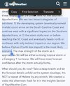
As far as the conditions most of us in Central North Carolina might see, Florence might be a good comparison. 94L may become a slow moving Category 1 hurricane like Florence wherever it comes ashore dumping buckets of rain along its path. Florence broke many rainfall records for NC coastal communities with around 35 inches being recorded in Elizabeth City and 25 in Wilmington. In the KRDU area, rainfall totals ranged anywhere from six to eight inches around Raleigh and up to twelve inches in some locations south of Raleigh.florence from 2018 might be close, cant remember if it made landfall in sc or not though
Wow that’s slow
yeah nhc likes the idea of it doing the stanky leg off the sc coast for a bit. would spell a rather rainy week for much of the SC and SENC coastlinesWow that’s slow
East of I-77and south of I-20 for sure. Little to none probably for the northwest half of GA and over upstate SC. MYR, CHS, ILM, and RDU would probably see 15+ out of it.I see they're forecasting the potential stall here, which man oh man, it'd be potentially nightmare-ish rain wise.
Southwest Half of Georgia won't get much either unless something changes. Most of the rain in Georgia appears to be East of I-75. I'm expecting a nice, dry week next week with a good amount of sunshine.East of I-77and south of I-20 for sure. Little to none probably for the northwest half of GA and over upstate SC. MYR, CHS, ILM, and RDU would probably see 15+ out of it.

Ray is in the “take a deep breath” camp. Which is good to seeI'm starting to think my initial position of it never making landfall may win the day. Once we start seeing widespread stalling on modeling, it's hard to go back. I've seen that over and over. Next little bit of time is going to be critical. It has to start getting its act together soon or it ain't getting in.
Edit: Yep
View attachment 175192

Yeah it getting buried near Cuba right now may end up being the difference. If the current center remains dominant it may be too slow and get yanked by Humberto. Very fine lineI'm starting to think my initial position of it never making landfall may win the day. Once we start seeing widespread stalling on modeling, it's hard to go back. I've seen that over and over. Next little bit of time is going to be critical. It has to start getting its act together soon or it ain't getting in.
Edit: Yep
View attachment 175192
There is literally nothing that supports this if we get a landfalling tropical system …East of I-77and south of I-20 for sure. Little to none probably for the northwest half of GA and over upstate SC. MYR, CHS, ILM, and RDU would probably see 15+ out of it.
