• Hello, please take a minute to check out our awesome content, contributed by the wonderful members of our community. We hope you'll add your own thoughts and opinions by making a free account!

Tropical TS Erin

That initial NHS track is moving Erin along a little further south and west than I thought it would. I still agree with the models and the historical data on storms that develop rapidly after crossing the Cabo Verde Islands which both show that Erin will probably go out to sea.
 
Last edited:
12Z UKMET: further W than the 0Z’s recurve at 63.3W with a threat to Bermuda as it ends the run moving NNW:

NEW TROPICAL CYCLONE FORECAST TO DEVELOP AFTER 24 HOURS
FORECAST POSITION AT T+ 24 : 17.8N 35.1W

LEAD CENTRAL MAXIMUM WIND
VERIFYING TIME TIME POSITION PRESSURE (MB) SPEED (KNOTS)
-------------- ---- -------- ------------- -------------
1200UTC 12.08.2025 24 17.8N 35.1W 1008 30
0000UTC 13.08.2025 36 17.3N 39.1W 1007 30
1200UTC 13.08.2025 48 17.1N 42.2W 1006 28
0000UTC 14.08.2025 60 17.8N 44.6W 1007 29
1200UTC 14.08.2025 72 19.4N 48.1W 1007 32
0000UTC 15.08.2025 84 20.8N 51.7W 1008 31
1200UTC 15.08.2025 96 21.4N 55.0W 1007 30
0000UTC 16.08.2025 108 22.0N 57.9W 1006 34
1200UTC 16.08.2025 120 22.3N 60.2W 1003 43
0000UTC 17.08.2025 132 23.4N 62.8W 1002 44
1200UTC 17.08.2025 144 25.0N 64.3W 1001 47
0000UTC 18.08.2025 156 26.0N 65.4W 999 45
1200UTC 18.08.2025 168 27.5N 66.0W 998 50
 
Honestly considering the name, I would prepare for impact.
I agree....such a long time for a forecast to hold. I wonder how many forecast made 10-11 days out actually held. I bet not many. Guess these could always be a first.
 
OTS definitely seems likely, but it'll be worth keeping an eye on until it does the little WSW dip and we know better on ridge strength.

It'll at least be a nice distraction for me from other issues.

Anyway, 12z Euro is weaker and a little to the south so far through 96.
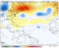
 
OTS definitely seems likely, but it'll be worth keeping an eye on until it does the little WSW dip and we know better on ridge strength.

It'll at least be a nice distraction for me from other issues.

Anyway, 12z Euro is weaker and a little to the south so far through 96.
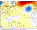
It's that time of year for strong ridging in the Atlantic. It's not out of the question we see something stronger show up as far as the ridge goes in upcoming modeling.
 
The disturbance off the NC coast develops into a LP on the EPS and helps to create a weakness in the ridging in the Atlantic. The ridge tries to build back from the east as Erin approaches, but then another trough in eastern Canada helps to create additional weakness in the Atlantic ridging (thanks to the southern US ridge retrograding), which allows Erin to escape and eventually merge with the eastern Canada trough, keeping our area in general troughing. Eventually the Atlantic ridge builds back in from the east, while the US ridge backs west into the Four Corners area.

This seems likely to me, as the seasonal pattern has been for ridging in the Southeast to migrate west all summer. That said, it's still worth watching. I'd give it a 75% chance of a recurve, especially since it will be coming at us rather far north.

1.png
2.png
3.png
4.png
 
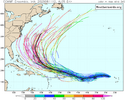
I counted 6 of 30 (20%) 12Z GEFS members hitting the Conus. I’m not worried about it and am pretty optimistic the U.S. will not be hit, especially considering the climo related to the current 17.4N latitude so far E in the MDR. But though still small, 20% is the highest since at least 6Z of yesterday fwiw. Likely will go back down later runs today.
 
I counted 6 of 30 (20%) 12Z GEFS members hitting the Conus. I’m not worried about it and am pretty optimistic the U.S. will not be hit, especially considering the climo related to the current 17.4N latitude so far E in the MDR. But though still small, 20% is the highest since at least 6Z of yesterday fwiw. Likely will go back down later runs today.
Odd that the stronger the system the more likely to take the western trackIMG_5718.png
 
Odd that the stronger the system the more likely to take the western trackView attachment 174134

Yeah, Shaggy, that’s counterintuitive and also disagrees with the forecasters who said the stronger it is early on, the earlier it will recurve (which is typical). So, I’m confused by the tracks of the 12Z Euro in your post.
 
Yeah, Shaggy, that’s counterintuitive and also disagrees with the forecasters who said the stronger it is early on, the earlier it will recurve (which is typical). So, I’m confused by the tracks of the 12Z Euro in your post.
Looking at the tracks best I can it appears the game is after the southwest bend early on. The stronger systems look to stay on a lower trajectory and a more west solution.

The question seems to be what's that steering mechanism? Maybe a mid level ridge pressing on the deeper stronger system.....seems that's what happened with Irma when the models kept turning her up the east coast but she stayed on that due west track
 
That was a shift west in the latest GFS run. Erin might split the goalposts between Bermuda and the Outer Banks instead of going over or to the east of Bermuda. I still think Erin will come close enough to the North Carolina coast to have some effects as a far as rough seas and dangerous rip currents along the Outer Banks.
 
18Z GFS ensemble at 240: still heavily favors safe recurve from Conus though with some threatening Bermuda and Canada; but 6 of 30 (20%) are far to very far SW outliers, which is similar to the 12Z:

IMG_4332.png
 
the big ones like to tug poleward. Saves us more times than not here along the east coast. The big ones in the gulf do the same thing, the only difference is there’s landmass to the north into the gulf states.

Most of them yeah but to be fair Irma and Katrina both moved southwest for a bit. Actually the next few days will tell the story because Irma moved southwest over the Antilles after this point and I'm seeing a lot of comparisons to it. Yes they did recurve.... Over Florida and Louisiana...

Andrew was also moving almost straight west for days

I mean I do think OTS is heavily favored but it's not guaranteed
 
Back
Top