Probably multiple severe weather opportunities across the region the next 5-7 days
-
Hello, please take a minute to check out our awesome content, contributed by the wonderful members of our community. We hope you'll add your own thoughts and opinions by making a free account!
You are using an out of date browser. It may not display this or other websites correctly.
You should upgrade or use an alternative browser.
You should upgrade or use an alternative browser.
Severe 12/26-1/1 Severe 🌩
- Thread starter SD
- Start date
- Joined
- Jan 5, 2017
- Messages
- 3,802
- Reaction score
- 6,051
It is looking rough down in southern MS on Saturday. NAM spitting out PDS Tornado threats. Further east better hope the wedge holds.

- Joined
- Jan 5, 2017
- Messages
- 3,802
- Reaction score
- 6,051
After looking at it a bit closer, northern MS has best shear but the instability is better in the south. It's still a ways out there, so we'll see how it trends.
ITUSETOSNOW
Member
Area Forecast Discussion
National Weather Service Peachtree City GA
656 AM EST Thu Dec 26 2024
...New 12Z Aviation Discussion...
.KEY MESSAGES...
Updated at 651 AM EST Thu Dec 26 2024
- Cool temps north GA through Friday due to cold-air damming
event persisting into Saturday.
- Scattered showers expected Friday NW spreading east and
increasing in coverage and intensity Saturday and Sunday.
- Heavy rain and strong or even some severe storms possible on
Sunday with up to 3 inches of rain possible.
- Temperatures will be much above normal through the weekend and
into early next week, with colder temperatures returning by
mid-week.
accu35
Member
Could there be severe weather in southwest AL?
- Joined
- Jan 5, 2017
- Messages
- 3,802
- Reaction score
- 6,051
I think the chances are good that there will be severe storms in southwest AL on Sunday.Could there be severe weather in southwest AL?
JHS
Member
Maybe some severe there too on Saturday. The slight risk goes up to the Miss and AL border.I think the chances are good that there will be severe storms in southwest AL on Sunday.

Belle Lechat
Member
- Joined
- Aug 29, 2021
- Messages
- 1,547
- Reaction score
- 1,224
Brent
Member
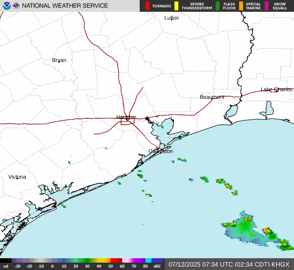
Near Houston earlier
JHS
Member
Wow this is escalating for Sat for sure. It looks rough in Miss into parts of AL now. CAD may save parts of NC and SC on Sunday, but this can change.
FROM NWS BMX. MAINLY FOR WEST , SOUTHWEST AND CENTRAL BAMA
.LONG TERM...
(Saturday night through next Thursday)
Issued at 350 AM CST FRI DEC 27 2024
Key Messages:
- Severe weather is likely to continue into Saturday night and early
Sunday morning with the risk waning with time and eastward extent.
Threats include tornadoes, damaging winds up to 60 mph, and large
hail.
Models indicate a broad swath of warm sector convection will be
ongoing across Central Alabama at the start of Saturday evening with
stronger storms initially carrying a primary risk for large hail
or severe wind gusts as indicated by modestly steep lapse rates
and eff. bulk shear as high as 50-60kts. Around this time, the
surface low will be deepening over the Mississippi River as the
mid-level portion of the trough attempts to take on a slight
negative tilt. The low-level jet really begins to kick in after
6-7 PM with 50kts of 850mb flow nudging into our west then
expanding across the area, resulting in a more favorable shear
orientation for tornadoes with curved hodographs and progged eff.
SRH values of 300-400 m2/s2. As we continue to move within range
of the hi-resolution models, we may get a better idea of how much
the afternoon and pre-frontal convection will impact the quality
of the warm sector, as that still appears to be the main question
with some of our early hi-res solutions indicating that there
could be some hampering of the thermodynamics due to the
afternoon/evening rainfall. Nonetheless, the risk for tornadoes
certainly looks to become maximized across western, especially
southwestern, portions of the area Saturday night as the surface
low lifts towards Tennessee leading to enhanced dynamics as a
broken line of multi-cells, with some embedded supercells, enters
the western portions of the area along and ahead of the cold
front. This activity will progress eastward during the overnight
hours then most likely be focused across eastern portions of the
area by Sunday morning. The risk for all modes of severe weather
should decrease with time and eastward extent as both instability
wanes and as the low-level jet lifts north of the area as the mid-
level trough pulls further away. We will at least hold on to a
lower end risk of severe weather Sunday morning in the east until
the front and associated thunderstorms clear the area shortly
after sunrise.
Following this active period, another cold front is forecast to
arrive on Tuesday, but moisture return will be quite limited ahead
of this front, and for now we don`t expect anything more than
scattered, light showers Tuesday morning. The weather turns colder
and drier for the second half of the week as the pattern over the
CONUS becomes characterized by broad troughing over the eastern half
and broad ridging over the western half with deep west to
northwesterly flow over Central Alabama.
Webberweather53
Meteorologist
Lots of severe weather to go around the next few days, Saturday looks like a big day over Dixie Alley.


At least it seems I know what I'm doing sometimes. Good to see this general idea from a couple weeks ago is panning out.
At least it seems I know what I'm doing sometimes. Good to see this general idea from a couple weeks ago is panning out.
The general stage is being set for some sort of severe weather outbreak over the southern-eastern us after Christmas.
Big pacific jet extension then a collapse and a transition into a colder pattern in early January will require shortening wavelengths and strong cyclones/troughs to use up the background westerly momentum.
Probably will get at least one big storm system that occludes up into the lakes or so and sets the table for the Hudson Bay vortex again.
We’re pretty mild beforehand, won’t have much of an issue getting good instability pretty far to the north for this time of year too
Webberweather53
Meteorologist
If we can get this Global Wind Oscillation (GWO) look in the spring (i.e. decreasing AAMa and poleward shifting anomalies), we're probably looking at an outbreak sequence over the Plains & SE US.


Webberweather53
Meteorologist
Close-up for NC's day 3.

JHS
Member
Hopefully not like 2011. That was the season of a lifetime, but somehow the GSP county warning area missed most of it.If we can get this Global Wind Oscillation (GWO) look in the spring (i.e. decreasing AAMa and poleward shifting anomalies), we're probably looking at an outbreak sequence over the Plains & SE US.
View attachment 156863
View attachment 156864
I think we have a problem around here Sunday unless we can fire off a bunch of showers /convection earlier in the day
Last edited:
JHS
Member
The NAM 3k has 2 rounds for some of us in the Carolinas on Sunday. That 2nd line breaks up some as it moves my way and the sounding when it comes in supports tornadoes and shows 450 SBCAPE here.I think we have a problem around here Sunday unless we can fire off a bunch of showers /convection earlier in the day
accu35
Member
I’m in the enhanced risk here in SW Bama. Any chance we could go to a moderate?
tennessee storm
Member
Kind late for me watching this system but I’m catching up. Say there is a pretty good shot u go under moderate risk for tomorrow . Lapse rates look great low level shear modest instability . Winter threats don’t take a lot of instability be honestI’m in the enhanced risk here in SW Bama. Any chance we could go to a moderate?

I wouldn't be terribly surprised if your area over into South Central MS is upgraded overnight. I think the big question mark is how quickly do things go linear. The early stages to your west probably has a higher chance of being super cellular and tornadic but any delay in forcing and the super cell/tornado threat creeps eastI’m in the enhanced risk here in SW Bama. Any chance we could go to a moderate?
A lot of the cells in MS today have some rotation.
Gulf Coast Weather
Member
Confirmed tornado currently on the southwest side of Mobile, AL
LukeBarrette
im north of 90% of people on here so yeah
Meteorology Student
Member
2024 Supporter
2017-2023 Supporter

East of Roanoke Sunday night…
Lapse rates impressive for an East Coast setup.
ITUSETOSNOW
Member
I just heard a massive clap of thunder,,,30306...43 degrees!!!
Webberweather53
Meteorologist
Holy 
A 45% tor on the nadocast??

A 45% tor on the nadocast??
Detective WX
Member
Currently raining at my house with 44 degree temp. Looks like that wedge may not save our boat this time.
Last edited:
Webberweather53
Meteorologist
Moderate risk is very likely coming down the pipe here based on what the 0z runs look like. This is a rather high end event for late December
My goodness
It's weird to see the HRRR more threatening than the 3k but the 3k looks weird with the multiple lines of convection
BHS1975
Member
Sometimes the HRRR will back off last minute.It's weird to see the HRRR more threatening than the 3k but the 3k looks weird with the multiple lines of convection

Upgraded to Moderate
Day 2 - 5% tornado

Guess we will have to pay attention to this around here Sunday. I was.hoping it would just be rain and a little wind.
accu35
Member
Well looks like I’m in the Mod risk now
First I look at the glorious winter weather model runs on the January thread and now we are tracking severe weather for Sunday. Business has definitely picked up in this forum.