- Joined
- Jan 23, 2021
- Messages
- 4,604
- Reaction score
- 15,202
- Location
- Lebanon Township, Durham County NC
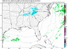
I'll allow a waxhaw jackpot with this oneNAM 3km Snow Output

I'll allow a waxhaw jackpot with this oneNAM 3km Snow Output
I’m all inI'll allow a waxhaw jackpot with this one


I typically follow these types of systems approaching from the NW moreso at the 500mb level as you typically want to be along or north of the track of the 500mb vort max to get in on the precip. For this system, the modeled precip seems to be more closely tied to the behavior at the 700mb level - maybe because it's a compact system??
Anyway, here is the RH rolling thru at 700mb
On the radar simulation, you can see the precip enhance and slow down a touch as it breaks out in the piedmont...this matches well with what typically happens in these scenarios as the upstate mesolow forms and tracks ESE.
Here's the mesolow in the upstate


This even gets me involved, so we know you can toss this one out lolCanadian RGEM / RDPS is a little farther north (more like the HRRR). The Canadian suite of models has performed pretty well over the years in NW flow events out into the piedmont
Usually, yes. If you can spin up a mesolow in the upstate though, that can really enhance precip in the lee.This even gets me involved, so we know you can toss this one out lol
Pretty much all of the guidance except this one shows a gap in coverage immediately east of the mountains, which is probably accurate, given downsloping.

You have no authority to issue a winter weather advisory. I'd think twice about your wording there and consider recanting it before someone reports you to the NWS. I'll confess, your shtick can at times be comical, but impersonating the NWS is a federal offense.I’m going to go ahead and issue a winter weather advisory for Iredell and Davie for 1” snow but need to watch radar evolution because I think this will spread into High Point NC. Wilkes and Yadkin would not qualify due to threshold being 2”. Those areas may see very light accumulation. View attachment 155308
Whoever knowingly issues or publishes any counterfeit weather forecast or warning of weather conditions falsely representing such forecast or warning to have been issued or published by the Weather Bureau, United States Signal Service, or other branch of the Government service, shall be fined under this title or imprisoned not more than ninety days, or both..

I re-worded it to say snow advisory since they do not issue those anymore.You have no authority to issue a winter weather advisory. I'd think twice about your wording there and consider recanting it before someone reports you to the NWS. I'll confess, your shtick can at times be comical, but impersonating the NWS is a federal offense.
18 U.S. Code § 2074 - False weather reports
www.law.cornell.edu

I agree with the analysis by you and grit. That said, part of me wonders if the northern edge could be a little more enhanced due to PVA and geopotential height falls. So far today the northern edge of the precip shield over Iowa has been more enhanced than initially predicted. Of course, things look a little different on this side of the apps with the downsloping and other factors I know.Yeah this system is lower down because it’s very cold aloft. A lot of the precip is shallow topped with the DGZ ~750 mb. The 500mb vort max is disconnected with the low level forcing/lift here, mainly coming from 850mb convergence and frontogenesis near the mesolow.
I think the place to be in this event is the southwestern and southern Piedmont (Charlotte to Fayetteville NC or so and maybe a tad north of that). I can see very minor accumulations on elevated surface for a lucky few tonight.
Oth, over places like Raleigh low level forcing/convergence doesn’t look sufficient to overcome the sub-cloud layer drying. Although a few flurries are still possible there


NAM 3km suggests around 10-12:1 ratios during the time of precipitation. Surface temps would be the limiting factor to better. It's honestly more rare than most probably realize for us to get true 10:1 though, so this ain't bad (by our standards)!Ratios should be pretty good here - 13:1 to 16:1 maybe?

Lol this event is overperforming in IL View attachment 155312
Was just seeing that, esp further north on the precip. Pulling for RDU to score tooLast couple HRRR runs have been getting slightly more beefy, esp compared to 12z
Feel like its gonna be tough to see more than a passing flurry or two up this way and in north central NC with these soundings. not that this is new information. just quite dryWas just seeing that, esp further north on the precip. Pulling for RDU to score too


Inching north/west at game time! Imagine that16z RAP-tastic!


Look at those bands coming in from out da lakes.12z NAM3 doing pretty well upstream right now, precip shield is def a bit wider in reality
View attachment 155323
View attachment 155324
meanwhile the hrrrrrrr
View attachment 155325


Those banding features closer to the meso low are interesting as well View attachment 155318