Cutoffs and wedges are the only thing that can keep the first 10 days or so seasonal otherwise it's warm. Mjo should get out of the MC by the first week of the month so we may see the pattern start to change around 10/10-10/15
-
Hello, please take a minute to check out our awesome content, contributed by the wonderful members of our community. We hope you'll add your own thoughts and opinions by making a free account!
You are using an out of date browser. It may not display this or other websites correctly.
You should upgrade or use an alternative browser.
You should upgrade or use an alternative browser.
Pattern October 2023 Thread
- Thread starter SD
- Start date
NBAcentel
Member
Wouldn’t shock me if we get a quick cold shot as the pacific trough gets back in place around mid month, get a quick shot of +PNA, then we overextend the pacific jet past mid month and go back to warmCutoffs and wedges are the only thing that can keep the first 10 days or so seasonal otherwise it's warm. Mjo should get out of the MC by the first week of the month so we may see the pattern start to change around 10/10-10/15

We usually get our 1st frost Oct 20th. Usually as result of a 2-3 day quick cool shot,then we struglle into Nov, always bottoming out 38-42 ,until second half month.
I always say, the very best weather of the year in MBY, most pleasant for being outside in the afternoon/ full on sun. Is Mid Oct- Turkey Day week. You can hunt,fish,golf,yardwork,or just hangout. Hard to beat 60 degrees and low DP's
I always say, the very best weather of the year in MBY, most pleasant for being outside in the afternoon/ full on sun. Is Mid Oct- Turkey Day week. You can hunt,fish,golf,yardwork,or just hangout. Hard to beat 60 degrees and low DP's
NBAcentel
Member
EPS has no sort of look that supports a cold front thru hour 360… goes from eastern ridge to CONUS ridge to end off 


Might as well get the winter pattern going in full force.EPS has no sort of look that supports a cold front thru hour 360… goes from eastern ridge to CONUS ridge to end off View attachment 137231View attachment 137232View attachment 137233View attachment 137234
NoSnowATL
Member
What a rush

Could we ask everyone in Florida to turn on their fans and point them north so we could cash in on some of that?
Maybe a bit of refreshing air starting around the 9th or 10th. #VooDoo

Warm falls are the best! The longer we have to wait on the cold, the better! Who wants 15-20 below normal in October, it’s a complete waste! Loving this lookEPS has no sort of look that supports a cold front thru hour 360… goes from eastern ridge to CONUS ridge to end off View attachment 137231View attachment 137232View attachment 137233View attachment 137234

90s looking like a good bet for the lower southwest and maybe over central Cuba.

I know from my time in the Navy that 90s in California, even in Northern California is not an unusual occurrence.90s looking like a good bet for the lower southwest and maybe over central Cuba.
View attachment 137249
NBAcentel
Member
Indian summer not going anywhere 


NoSnowATL
Member

JHS
Member
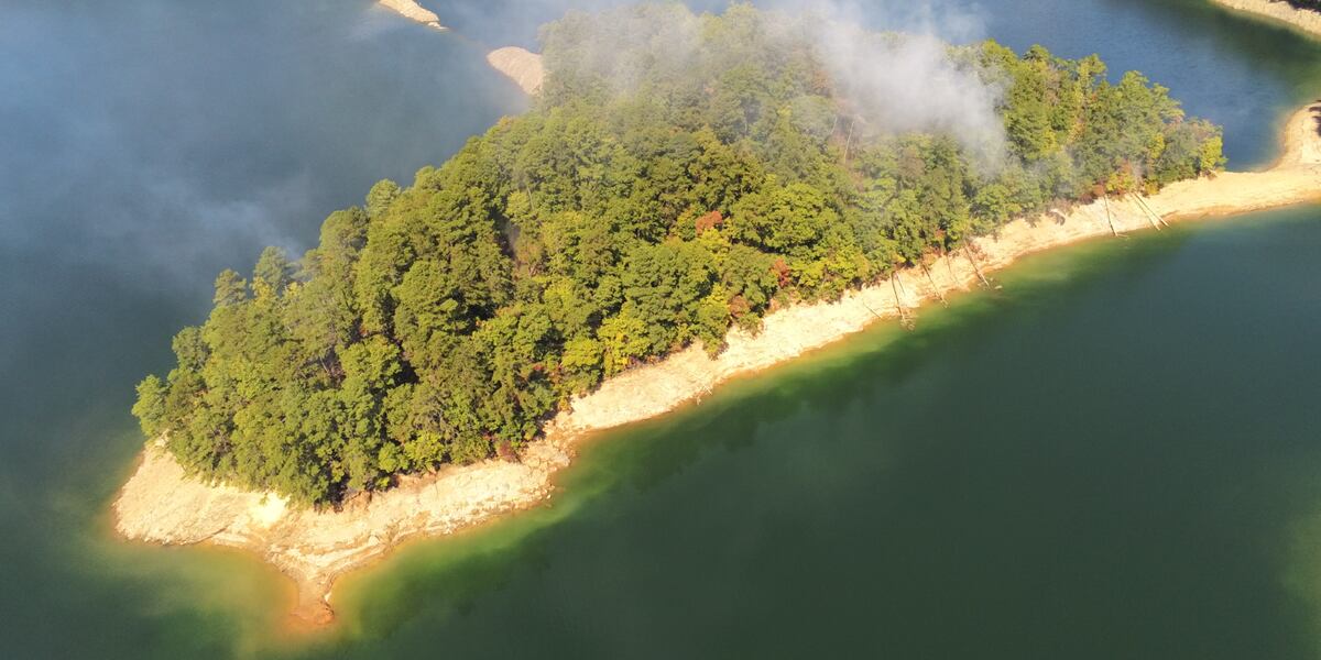
Great Smoky Mountains National Park firefighters contain wildfire near Fontana Lake
Great Smoky Mountains National Park announced that firefighters are responding to a wildfire burning near backcountry campsite 87 on Fontana Lake’s shore.
 www.foxcarolina.com
Hopefully this is not the start of a 2016 repeat. Models do not look great though.
accu35
Member

Will this work?
Brent
Member
Winter is coming 
JHS
Member
Still dry, but that would be nice for temps. It would not take much to change this to a severe weather episode either. Would be a freeze for the mountains for at least 1 morning with 40's for many of us and 62-68 for highs.View attachment 137264
Will this work?
ATLwxfan
Member
Downeastnc
Member
The end of the GFS was fallish...

Itryatgolf
Member
Quick temporary cool shot due to a +pna spike. But could be first taste of fall though
When Indian summer!??????
Yep! Come to papa?Winter is coming View attachment 137265

Crazy change on the models n the day 8 range into the long range in the past twenty four hours.
The 0z Euro was not nearly as drastic as the 0z GFS was. It did show a bit of cool shot coming down into the Midwest but it looks like it was setting up to give more a glancing shot into the southeast. The 0z GFS is basically showing the same thing as the Euro.Crazy change on the models n the day 8 range into the long range in the past twenty four hours.
iGRXY
Member
The Euro was also about to drop the hammer and really get this thing going. 10/10-10/15 has been the time period that we have been looking at to make a flip and this is coming a bit early. It'll probably get pushed back a few days, but still good to see the models getting rid of the eastern ridge.The 0z Euro was not nearly as drastic as the 0z GFS was. It did show a bit of cool shot coming down into the Midwest but it looks like it was setting up to give more a glancing shot into the southeast. The 0z GFS is basically showing the same thing as the Euro.


The Euro was also about to drop the hammer and really get this thing going. 10/10-10/15 has been the time period that we have been looking at to make a flip and this is coming a bit early. It'll probably get pushed back a few days, but still good to see the models getting rid of the eastern ridge.
Yep. I really don’t care if we stay a degree or two above average because that is still amazing weather, but I want that ridge smashed.
I agree. I think it’s headed towards a pattern that has a bunch of days of average temperatures, which in October is very nice.The Euro was also about to drop the hammer and really get this thing going. 10/10-10/15 has been the time period that we have been looking at to make a flip and this is coming a bit early. It'll probably get pushed back a few days, but still good to see the models getting rid of the eastern ridge.
ATLwxfan
Member
GFS much more muted with the cold at 06z. October is for 80’s.
Sent from my iPhone using Tapatalk
Sent from my iPhone using Tapatalk
- Joined
- Jan 23, 2021
- Messages
- 4,603
- Reaction score
- 15,199
- Location
- Lebanon Township, Durham County NC
GFS much more muted with the cold at 06z. October is for 80’s.
Sent from my iPhone using Tapatalk


???

W
WSW
Guest
Yuck! I'll take the 60s/70s please. Actually the average high for October in NW Virginia is around 65-66. IAD is 68/44 I believe.GFS much more muted with the cold at 06z. October is for 80’s.
Sent from my iPhone using Tapatalk
W
WSW
Guest
lOctober 10 1979 I was living in Western Fairfax County and we had snow on the ground....lol. Up to 10 inches in the Shenandoah Valley!
ATLwxfan
Member
More muted for the Midwest and shorter duration. Should still feel seasonable for many in the south.
Sent from my iPhone using Tapatalk
Sweet. You don’t hate to see it.

Gotta love watching the Asia to North pac and train go to work and how a bomb S of the aleutians makes or breaks a big cold dump into the US
NBAcentel
Member
Pretty massive changes in the day 7-10 range as the overall pattern has slowed/amplified on the pacific
NoSnowATL
Member
winter preview


What a shift over the last 24 hours.
Itryatgolf
Member
Like I mentioned yesterday, just a quick cool shot with a +pna spike
NoSnowATL
Member
