Detective WX
Member
Welcome to the hottest, most boring month of the year for Deep South. Wash, rinse, repeat.
Lock in 4,3,2,Welcome to the hottest, most boring month of the year for Deep South. Wash, rinse, repeat.
Wait August is fall…….I like July for the simple fact it’s one month away from fall
Ah yes the cool fall days of AugustI like July for the simple fact it’s one month away from fall
Wait....what....huh???I like July for the simple fact it’s one month away from fall
It’s south Alabama . Pretty sure July is used to describe May - September there . Y’all been 1 month from fall since May ! That or the education system is in more shambles than I thought.Wait August is fall…….
Sorry my timing was off. September 22 is officially first day of fall but normally we do start getting cool fronts before then.Wait....what....huh???
He will drive to Maine to chase August fall! Don’t tempt himWait....what....huh???


ZCZC MIATWOAT ALL
TTAA00 KNHC DDHHMM
Tropical Weather Outlook
NWS National Hurricane Center Miami FL
200 PM EDT Fri Jul 1 2022
For the North Atlantic...Caribbean Sea and the Gulf of Mexico:
Active Systems:
The National Hurricane Center is issuing advisories on newly
formed Tropical Storm Bonnie, located over the southwestern
Caribbean Sea.
1. Near the Southeastern US:
Satellite and radar images along with surface observations indicate
that a low pressure system has formed just off the coast of
Savannah, Georgia. Surface pressures are high in this region, and
development, if any, of this system should be slow to occur while it
drifts northeastward along the southeast U.S. coastline during the
next day or so. Regardless of development, this system is
expected to produce heavy rains, which could cause flash flooding
across portions of southeastern Georgia and the Carolinas through
tonight and into Saturday. See products issued by the Weather
Prediction Center and your local National Weather Service forecast
office for more details.
* Formation chance through 48 hours...low...10 percent.
* Formation chance through 5 days...low...10 percent.

@WeatherNC I think its time you shave.

0.00000000000drop.39 today 3rd biggest rain total since 5/1 lol


Y’all quit whining! What could go wrong??View attachment 119625

I'll meet you at cracker barrel for a nice game of checkersRainVille, USAView attachment 119628
By the fireplace!?I'll meet you at cracker barrel for a nice game of checkers
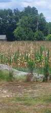
We are boned here. We get these little showers every 10 days or so but it's too late for 90% of the corn around here. It's gonna be a low yield as most corn stalks are only having one ear at best.0.00000000000drop

Same here in Sw Rutherford. Been missing us on all sides the last 3 weeks.This is starting to get annoying. 16 days without a drop.View attachment 119637

I'd take 1/3rd of some of those totals and be super happyView attachment 119647
Today's edition of "wow, must be nice...." features Forsyth County getting a total soak job
Heading down to Carolina Beach in a kut an hour for a few days. Hope the showers hold offrain showers in between rain showers..