Blue_Ridge_Escarpment
Member
Oh yeah…


And we've seen these trailing upper waves produce before, just this year, it will probably come down to timing and location but definite potential for someone to hit the "sweet spot"I think if you are writing this event off or not interested you are selling this one short but maybe I'm getting too excited from the rgem and nams. We almost have 2 shots here 1 with the anafrontal stuff and 1 with the trough itself. The rgem overlapped the 2 over Central nc on the last run
I found your candy heart right here, Curtesy the 06 GFS.6Z GFS insists on teasing our neck of the woods with what could well be a final dusting for Valentine's Day. No one else is interested in even giving us some of those nasty-tasting candy hearts.

If rates overcome, we could have some fun.All the snow caveats aside the discrepancy in the QPF here is interesting, I bet the NAMs increase precip amounts over the next few runs
View attachment 113358


I actually posted a trend GIF of it earlier and yes the 12Z didn't look as good as other models but it actually had more qpf. Problem is BL temps, which is a problem and concerning when the RGEM shows that but thanks for postingHow did the 12z RDPS look? Oh wait! Here it is…View attachment 113375
HAHA! Just having a little fun with you guys. I have no clue what the temps look like.I actually posted a trend GIF of it earlier and yes the 12Z didn't look as good as other models but it actually had more qpf. Problem is BL temps, which is a problem and concerning when the RGEM shows that but thanks for posting


Exactly what I’ve been thinking


I’m not buying anything over 3 inches here in Roanoke, but certainly impressive.My goodness, western areas get hammered per HRRR and it get's a little more amped up each run. But can it be believed

I’ll take a flizzard cash out and call it a season it’s been funToo bad this is marginal temps and middle of the day
 HRRR 9” over Alleghaney county
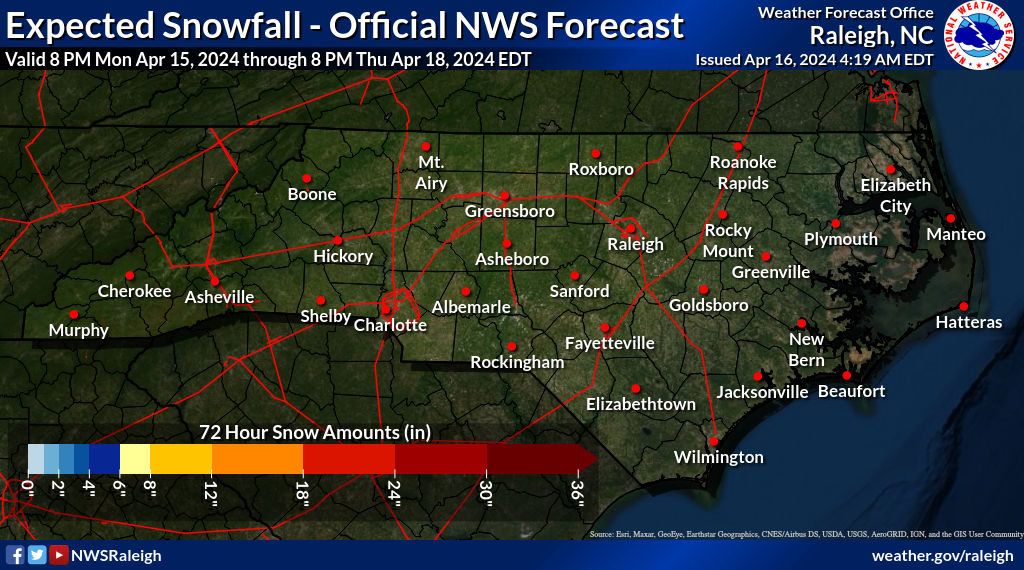
Latest NWS totals. Unfortunately looks to have cut back slightly on amounts from early AM.
Good catch. I had only noticed the lesser overall extent as you mentioned and didn't think to check for higher totals up N and W.Obviously, they brought the souther edge northward and reduced totals slightly from the early morning update. However, the totals for extreme north along the state line went up. Though insignificant, Eden went from 0.6” to 0.9” for example. I’m on the Guilford/Rockingham line. I’m expecting a dusting to 0.5”
Seems reasonable, only caveat I guess could be if the upper wave slows down a tick and snow can fall after sunset, might have a better chance of light accumulations. However, our trends are usually earlier arrival precip so midday snow melts before sunset most likely lolObviously, they brought the souther edge northward and reduced totals slightly from the early morning update. However, the totals for extreme north along the state line went up. Though insignificant, Eden went from 0.6” to 0.9” for example. I’m on the Guilford/Rockingham line. I’m expecting a dusting to 0.5”
honey no offense but do you anything about my wx or the microclimates of the northern foothillsHRRR has close to 2" even in by backyard. Not buying that for a second. Precip will likely arrive before model guidance by a few hours which favors western areas and the upstate but lets be honest about this. Max precip will probably be around 0.25"-0.3" within the band and ratios will be likely be somewhere around 5:1. Couple that with the fact that it will be entirely rate driven as the mid levels and surface are way above freezing and you'll waste a good bit of precip within the dynamic cooling process. Surface temps also don't look to go below freezing outside of the mountains and will likely be in the mid 30's even if you can get it to switch to snow. Nothing about this screams accumulating snow south of the NC/VA line or outside of the mountains and immediate western foothills. And even there a dusting to 1" is likely going to be the max and that maybe generous given nothing really supports accumulating snowfall. Best bet for those east is overperforming with precip and hoping some falls after dark.


