Z
Zander98al
Guest
A big time soaker is on the way for the already saturated south. With possibility of some strong storms.


That escalated quicklySPC already putting out 30% severe weather odds for Wednesday.View attachment 33689

Is this hype again or does it seem to he really bad ?Me. Reed “the mustache” Timmer posted this on FB Today ...next Wednesday
View attachment 33697
Lol everything is hype for reed timmer lol its always "prolific outbreak" from him. I think its just a straight line wind threat with possibility of a tornado or twoIs this hype again or does it seem to he really bad ?
surface winds do appear veering... more uni directional should limit the tornado potential at this time... still like to watch model trendsLol everything is hype for reed timmer lol its always "prolific outbreak" from him. I think its just a straight line wind threat with possibility of a tornado or two


 sounding from the NAM ahead of the low topped line of convection, once again, strong wind energy, it does have little backing in the lower levels but forcing is linear and critical angles aren’t to impressive, altho there not to bad


The 3km NAM meanwhile wants to hold the precipitation farther north. Still though areas where the heavy rain sets up get hit with loads of rain.Take this FWIW but the 18z HRRR is very concerning flooding wise from Louisiana-Alabama, and even places farther east somewhat. A band of heavy rain moves in tomorrow morning to those regions and lasts throughout the day and through the rest of the run. If that’s to verify someone is going to see 6-10 inches of rain maybe even more especially in Mississippi
here are the rain accumulations from the 18 HRRR. Only goes through 06z Tuesday morning.
View attachment 33724
I should also probably note that the end of the run is still loaded with rain.
View attachment 33725


The 3km NAM meanwhile wants to hold the precipitation farther north. Still though areas where the heavy rain sets up get hit with loads of rain.
To show the difference compared to HRRR here is the accumulations at hour 36 for the NAM.
View attachment 33728
Here is also the rain still going at hour 36.
View attachment 33727
So which one typically does better with this set up? A slight difference like this will make a huge difference with who gets more rain given the sharp southern cutoff.
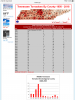
Yeah, that’s sort shocked me also. But last few years seems like mid tennessee has had more severe weather than the western half... been a trendSince we are talking sever weather I came across this page and was very surprised to see that Middle Tennessee has had more tornadoes then west Tennessee over the last 30 years. In fact Middle Tennessee has averaged quite a bit more tornadoes then the rest of the state since 1995.

According to the hydrometer classification that is giant hailSolid looking hailstorm going on in Southern Arkansas.
Edit: Warned for tennis ball sized hail now. Wow.
View attachment 33753


Well if this verifies should basically finish off my roof (the shingles), I lost about 15-20 with the last one and calling insurance today.... seriously doubt they get out there before the next batch of wind/rain. I think we need a break from this messWill be interested to see how high the wind gets with the front this time. Was actually pretty impressive with the last storm.
View attachment 33785


Local offices still taking the HRRR as gospel smhwatch the hrrr slowly fold
View attachment 33794


That's a horrible drive even when dry.Ongoing flooding in BHam. ATL is next. That drive home tonight won’t be fun.

Sent from my iPhone using Tapatalk