We need to hope areas to our north take a direct hit from the 1st storm. A little snow cover wouldn’t hurt our chances with #2GFS is suppressed at 156, not the worst look ive ever seen.
-
Hello, please take a minute to check out our awesome content, contributed by the wonderful members of our community. We hope you'll add your own thoughts and opinions by making a free account!
You are using an out of date browser. It may not display this or other websites correctly.
You should upgrade or use an alternative browser.
You should upgrade or use an alternative browser.
GFS for storm #2 looked nice and suppressed at the surface but I’m really not in love with this MSLP look.. I guess it’s still “close”

NBAcentel
Member
Fv3 has that weak energy aswell at hour 150, folks you better hope that can do something because that is probably our last shot at something this winter for many
Actually the models have been slowly cooling down the medium range area and trying to give us a parade of upper level lows that if they can work together could produce eventually.. also think CAD potential is possible second half of March
NBAcentel
Member
Warmth is coming, MJO is going to be phase 4 in a few weeks which allows for a strong SER is form
Still mjo has way less effect now than it did before
snowlover91
Member
UK continues with the theme of a low moving through NC. We are getting to the point where the UK/Euro combo is tough to beat...

snowlover91
Member
This is the first GEFS run I’ve seen with a solid consensus in one camp... unfortunately it’s in the rain/warm camp similar to the Euro and UK. However the snow mean has increased since there are some bigger members in here skewing the mean.

NBAcentel
Member
Also let’s not forget that flare up of convection due to a downwelling Kelvin wave, that convection is headed towards Indonesia as webb mentioned last night, which argues warmer conditions, (sounds nice) and MJO Still has a effect for warmth into phase 4
 Once that -EPO/North Pacific block breaks down, and with a +AO/+NAO, the SER is gonna have room to flourish while the western US deals with troughiness
Once that -EPO/North Pacific block breaks down, and with a +AO/+NAO, the SER is gonna have room to flourish while the western US deals with troughinessSeems that’s it could trend well for NC but wave 1 looks to be a lost cause for the rest of the southeast .. I’m sure more waves behind thoThis is the first GEFS run I’ve seen with a solid consensus in one camp... unfortunately it’s in the rain/warm camp similar to the Euro and UK. I think wave one is done after seeing the 00z suite.
snowlover91
Member
Here’s the individual members.

NBAcentel
Member
This is the first GEFS run I’ve seen with a solid consensus in one camp... unfortunately it’s in the rain/warm camp similar to the Euro and UK. However the snow mean has increased since there are some bigger members in here skewing the mean.
Western SE actually still looks decent atm, I’m rooting for them
snowlover91
Member
Because of the heavier hitters this is the highest pure snow mean I’ve seen yet for wave 1.

GEFS aren’t backing down so neither will I
NBAcentel
Member
I’m tapping out with the first system but this second one has my attention 
snowlover91
Member
Quite a healthy snow mean through 192.

NBAcentel
Member
This storm could be a big one, many of the ensembles develops band of snow in the foothills/mountains and it would probably be convective in nature, then phase it with the coastal making it a big storm

Wow GEFS really dug there teeth into storm number two ... more support than storm number one Jeez ... getting interesting for sure ... but wanna see the king of course
WOW GEFS even try and bring in a THIRD system right over some of that cold air from those storms and we get another and it’s only 220 hours out (the THIRD system)
NBAcentel
Member
I trust this second storm much more, much better diving trof allowing low pressure development along a stalled boundary around the Gulf Stream off the nc/sc coast and a little western ridge spike 

LovingGulfLows
Member
- Joined
- Jan 5, 2017
- Messages
- 1,499
- Reaction score
- 4,100
Wouldn't mind if the western ridge was placed a little further west and taller on that GEFS mean run. Sharpen the trough more.
NBAcentel
Member
No joke, what do severe parameters look like, lol first wave went from a snow event to now this ?! Lol, anyways a bombing low and warmer temps aloft tell me severe wx or at least hslc 
Brent
Member
Last edited:
NBAcentel
Member
With the second system the euro/gefs looks similar except for that bombing low around Newfoundland, what did the euro show ? 

Snowflowxxl
Member
Larry went to sleep on us tonight lol. Weather.us has Euro maps but they are not very good, and take forever to load.
NBAcentel
Member
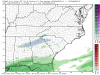
Rather interesting look just off the NC coast:
I like that look for sure considering a MW trend will happen, I said this earlier but this storm is much better in my eyes and could produce big totals if things go right
Snowflowxxl
Member
That is a way better look that’s what some people were getting excited about showing 8 inches of snow the other day. That actually has a chance.Rather interesting look just off the NC coast:
NBAcentel
Member
Pretty good agreement for that range 

NBAcentel
Member
Eps a bit stronger with the coastal tho 

NBAcentel
Member
I don’t know if I want this suppressed or not at this range lol, I can’t help but think of that whiffed coastal we had then also these other storms trended NW, anyways trend has been to get that trof axis more SW oriented/positive tilt, this allows room for the storm to come back west, 850s are really cold over much of the SE, like I said earlier this storm could be something big if things go right


Webberweather53
Meteorologist
Pretty obvious to see why the first storm went to ???
Our big vortex over southern Canada shifted from New England and the Lakes to the upper midwest and Manitoba in just 3-4 cycles of the EPS in the medium range, which essentially means we're trending towards a -PNA (shocker). That's a pretty substantial change in the forecast even for the EPS at this range.
Hopefully the rain we get from this is pretty warm and/or some thunderstorms would be nice.
.gif")
Our big vortex over southern Canada shifted from New England and the Lakes to the upper midwest and Manitoba in just 3-4 cycles of the EPS in the medium range, which essentially means we're trending towards a -PNA (shocker). That's a pretty substantial change in the forecast even for the EPS at this range.
Hopefully the rain we get from this is pretty warm and/or some thunderstorms would be nice.
NBAcentel
Member
Pretty obvious to see why the first storm went to ???
Our big vortex over southern Canada shifted from New England and the Lakes to the upper midwest and Manitoba in just 3-4 cycles of the EPS in the medium range, which essentially means we're trending towards a -PNA (shocker). That's a pretty substantial change in the forecast even for the EPS at this range.
Hopefully the rain we get from this is pretty warm and/or some thunderstorms would be nice.
View attachment 16760
What your opinion on the second one? I think it’s our best and last shot at a winter storm, I like the looks right now
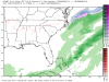
Not buying that euro solution. GFS still holding on to a severe winter storm southern/central Appalachian MTNS that could likely trend better for some on the board.
I expect some wild swings in the modeling this week. For one, I do not want to see the perfect solution and watch it trend worse and worse for 7 days. I would rather see thunderstorms warm and cold snow on both models as this shows a very violent March pattern. One that could easily produce 6-12” in the NC mountains and 3-6” east of the mountains. I wouldn’t write things off unless you lived from Atlanta GA to Charlotte NC to Wilmington NC line. This is a upper south-east pattern for heavy wet snow and rain south (no ice). Favors NC mountains, Hickory north, Piedmont Triad and out to Raleigh.

ATLwxfan
Member
Pretty obvious to see why the first storm went to
Our big vortex over southern Canada shifted from New England and the Lakes to the upper midwest and Manitoba in just 3-4 cycles of the EPS in the medium range, which essentially means we're trending towards a -PNA (shocker). That's a pretty substantial change in the forecast even for the EPS at this range.
Hopefully the rain we get from this is pretty warm and/or some thunderstorms would be nice.
View attachment 16760

I think many of us have had enough rain. Would be nice if this storm can just get shredded.
Sent from my iPhone using Tapatalk
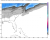
00z Euro: